
FCCInfo.com
A Service of Cavell, Mertz & Associates, Inc.
(855) FCC-INFO
|
|
|
|
|
||||||||||||||||
|
|
K270BZ Channel: 270D 101.9 MHz Phoenix, Arizona Service: FX - A translator or application for a translator. Facility ID: 152717 Fac. Service: FX Programming Delivery Method: Unspecified Status: License Application Accepted: 08/31/2023 Application Granted: 09/08/2023 File Number: -0000220318 License Expires: 10/01/2029 Application Type: License To Cover FCC Website Links: LMS Facility Details This Application Other K270BZ Applications Other K270BZ Applications in CDBS Including Superseded Applications Mailing Address Correspondence for K270BZ Correspondence related to application -0000220318 Service Contour - Open Street Map or USGS Map (60 dBu) Service Contour - KML / Google Earth (60 dBu) Facility Type: FM STATION Class: D, A Noncommercial educational operating with no more than 10W Site Location: 33-20-03.7 N 112-03-41.2 W (NAD 83) Site Location: 33-20-03.5 N 112-03-38.7 W (Converted to NAD 27) Effective Radiated Power: 0.22 kW Transmitter Output Power: 0.674 kW Antenna Center HAAT: 0 m Antenna Center AMSL: 810.2 m (2658 ft.) Antenna Center HAG: 14 m (46 ft.) Site Elevation: 796.2 m. (2612 ft.) Height Overall*: 100.6 m (330 ft.) (* As Filed In This Application, may differ from ASR Data, Below.) Directional Antenna Antenna Make/Model: NICOM BKG77 Antenna ID: 127955 Polarization: H
| ||||||||||||||||||
| Antenna Data for Antenna Id: 127955 K270BZ FX File: -0000220318 NICOM - BKG77 Service: FX | 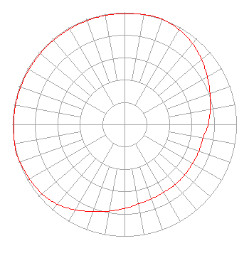 | ||||||||||||||||||
| Azimuth | Ratio | Azimuth | Ratio | Azimuth | Ratio | Azimuth | Ratio | ||||||||||||
| 0 | 0.990 | 10 | 0.996 | 15 | 1.000 | 20 | 0.996 | ||||||||||||
| 30 | 0.977 | 40 | 0.943 | 50 | 0.898 | 60 | 0.853 | ||||||||||||
| 70 | 0.812 | 80 | 0.777 | 90 | 0.747 | 100 | 0.712 | ||||||||||||
| 110 | 0.706 | 120 | 0.702 | 130 | 0.702 | 140 | 0.702 | ||||||||||||
| 150 | 0.702 | 160 | 0.707 | 170 | 0.722 | 180 | 0.752 | ||||||||||||
| 190 | 0.787 | 200 | 0.828 | 210 | 0.881 | 220 | 0.931 | ||||||||||||
| 230 | 0.963 | 240 | 0.978 | 250 | 0.992 | 255 | 1.000 | ||||||||||||
| 260 | 0.996 | 270 | 0.990 | 280 | 0.988 | 290 | 0.986 | ||||||||||||
| 300 | 0.983 | 310 | 0.983 | 320 | 0.983 | 330 | 0.983 | ||||||||||||
| 340 | 0.986 | 350 | 0.988 | ||||||||||||||||
Structure Registration Number 1308803 Structure Type: LTOWER Registered To: Vertical Bridge Development, LLC Structure Address: South Mountain/sec 16, T1s-r3e / Us-az-5065 Phoenix, AZ County Name: Maricopa County ASR Issued: 12/27/2018 Date Built: 11/12/2021 Site Elevation: 796.2 m (2612 ft.) Structure Height: 91.4 m (300 ft.) Height Overall: 100.6 m (330 ft.) Overall Height AMSL: 896.8 m (2942 ft.) FAA Determination: 10/16/2018 FAA Study #: 2018-AWP-13927-OE Paint & Light FAA Chapters: NONE 33-20-03.7 N 112-03-41.2 W (NAD 83) 33-20-03.5 N 112-03-38.7 W (Converted to NAD 27) |
Keene, CA 93531 Phone: 602-269-3121 Corporation | Title: Technical Consultant Date: 08/31/2023 Application Certifier CHAVEZ RADIO GROUP Chavez Radio Group Keene, CA 93531 Applicant Brad Deutsch Foster Garvey P.c. 1000 Potomac St., Nw Suite 200 Washington, DC 20007 Counsel DONALD LYNCH Horizon Broadcast Solutions, Llc 111 Sam Houston Drive Kerrville, TX 78028 TECHNICAL CONSULTANT | |||||||||||||||||