
FCCInfo.com
A Service of Cavell, Mertz & Associates, Inc.
(855) FCC-INFO
|
|
KVLT from 04/17/1997 |
|
|
||||||||||||||||
|
|
KVLT Channel: 203C2 88.5 MHz Temple, Texas Service: FM - A full-service FM station or application. Facility ID: 86326 Fac. Service: FM Status: License Application Accepted: 08/31/2023 Application Granted: 09/19/2023 File Number: -0000220288 License Expires: 08/01/2029 Application Type: License To Cover FCC Website Links: LMS Facility Details This Application Other KVLT Applications Other KVLT Applications in CDBS Including Superseded Applications Mailing Address Correspondence for KVLT Correspondence related to application -0000220288 Service Contour - Open Street Map or USGS Map (60 dBu) Service Contour - KML / Google Earth (60 dBu) Public Inspection Files Facility Type: NON-COMMERCIAL EDUC. FM Class: C2, A Zone II station; with 25kW-50kW ERP and a class contour distance 39km-52km Site Location: 30-59-09.0 N 97-37-57.0 W (NAD 83) Site Location: 30-59-08.3 N 97-37-56.0 W (Converted to NAD 27) Effective Radiated Power: 0 kW Horiz. ; 8.9 kW Vert. Transmitter Output Power: 1.56 kW Antenna Center HAAT: 0 m Horiz.; 183 m Vert. Antenna Center AMSL: 0 m Horiz.; 418 m Vert. Antenna Center HAG: 0 m Horiz.; 138 m Vert. Site Elevation: 279.9 m. (918 ft.) Height Overall*: 152.1 m (499 ft.) (* As Filed In This Application, may differ from ASR Data, Below.) Directional Antenna Antenna Make/Model: Electronics Research Inc. PAN301-1B-DA Antenna ID: 43301 Polarization:
| ||||||||||||||||||
| Antenna Data for Antenna Id: 43301 KVLT FM File: -0000220288 Electronics Research Inc. - PAN301-1B-DA Service: FM | 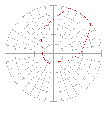 | ||||||||||||||||||
| Azimuth | Ratio | Azimuth | Ratio | Azimuth | Ratio | Azimuth | Ratio | ||||||||||||
| 0 | 0.707 | 10 | 0.837 | 20 | 1.000 | 30 | 1.000 | ||||||||||||
| 40 | 1.000 | 50 | 1.000 | 60 | 0.837 | 70 | 0.707 | ||||||||||||
| 80 | 0.632 | 90 | 0.548 | 100 | 0.447 | 110 | 0.387 | ||||||||||||
| 120 | 0.316 | 130 | 0.251 | 140 | 0.217 | 150 | 0.199 | ||||||||||||
| 160 | 0.199 | 170 | 0.224 | 180 | 0.224 | 190 | 0.224 | ||||||||||||
| 200 | 0.224 | 210 | 0.224 | 220 | 0.224 | 230 | 0.224 | ||||||||||||
| 240 | 0.224 | 250 | 0.224 | 260 | 0.224 | 270 | 0.224 | ||||||||||||
| 280 | 0.224 | 290 | 0.224 | 300 | 0.265 | 310 | 0.316 | ||||||||||||
| 320 | 0.387 | 330 | 0.447 | 340 | 0.548 | 350 | 0.632 | ||||||||||||
Structure Registration Number 1025503 Structure Type: TOWER Registered To: Pinnacle Towers LLC Structure Address: .4 Mi E Of Int Of Fm2482 & Eagle Nest Rd Youngsport, TX County Name: Bell County ASR Issued: 05/06/2016 Date Built: 10/15/1997 Site Elevation: 279.9 m (918 ft.) Structure Height: 146 m (479 ft.) Height Overall: 152.1 m (499 ft.) Overall Height AMSL: 432 m (1417 ft.) FAA Determination: 06/12/1996 FAA Study #: 96-ASW-1262-OE Paint & Light FAA Chapters: NONE 30-59-09.0 N 97-37-57.0 W (NAD 83) 30-59-08.3 N 97-37-56.0 W (Converted to NAD 27) |
5700 West Oaks Blvd. Rocklin, CA 95765 Phone: 916-251-1600 Not-for-Profit | Title: Acting Chief Financial Officer Date: 08/31/2023 Application Certifier EDUCATIONAL MEDIA FOUNDATION Educational Media Foundation 5700 West Oaks Blvd. Rocklin, CA 95765 Applicant LINDA ADAMS Educational Media Foundation 5700 West Oaks Blvd Rocklin, CA 95765 MARY N O'CONNOR Wilkinson Barker Knauer, Llp 1800 M. Street, N.w., Suite 800n Washington, DC 20036 | |||||||||||||||||