
FCCInfo.com
A Service of Cavell, Mertz & Associates, Inc.
(855) FCC-INFO
|
|
|
|
|
||||||||||||||||
|
|
KWLR-FM1 Channel: 245C3 96.9 MHz Little Rock, Arkansas Service: FB - A booster station or application for a booster. Facility ID: 778341 Fac. Service: FB Programming Delivery Method: Unspecified Status: Construction Permit Application Accepted: 10/02/2023 Application Granted: 01/08/2024 File Number: -0000221674 KWLR-FM1 CP Expires: 01/07/2027 Application Type: Construction Permit FCC Website Links: LMS Facility Details This Application Other KWLR-FM1 Applications Other KWLR-FM1 Applications in CDBS Including Superseded Applications Mailing Address Correspondence for KWLR-FM1 Correspondence related to application -0000221674 Service Contour - Open Street Map or USGS Map (60 dBu) Service Contour - KML / Google Earth (60 dBu) Facility Type: NON-COMMERCIAL EDUC. FM Class: C3, A Zone II station; with 6kW-25kW ERP and a class contour distance 28km-39km Site Location: 34-46-20.4 N 92-21-28.0 W (NAD 83) Site Location: 34-46-20.1 N 92-21-27.4 W (Converted to NAD 27) Effective Radiated Power: 1.4 kW Antenna Center HAAT: 0 m Antenna Center AMSL: 244.8 m (803 ft.) Antenna Center HAG: 65 m (213 ft.) Site Elevation: 179.8 m. (590 ft.) Height Overall*: 76.8 m (252 ft.) (* As Filed In This Application, may differ from ASR Data, Below.) Directional Antenna Antenna Make/Model: SHIVELY 6025-1 Antenna ID: 0 Polarization: H
| ||||||||||||||||||
| Antenna Data for Antenna Id: 0 KWLR-FM1 FB File: -0000221674 SHIVELY - 6025-1 Service: FB | 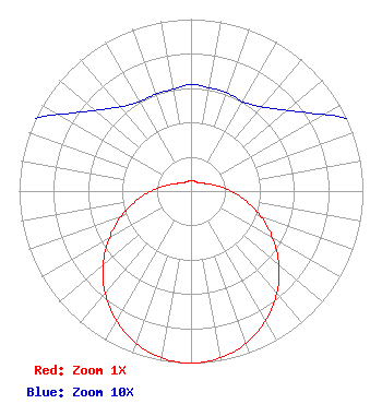 | ||||||||||||||||||
| Azimuth | Ratio | Azimuth | Ratio | Azimuth | Ratio | Azimuth | Ratio | ||||||||||||
| 0 | 0.062 | 10 | 0.061 | 20 | 0.061 | 30 | 0.060 | ||||||||||||
| 40 | 0.064 | 50 | 0.073 | 60 | 0.089 | 70 | 0.116 | ||||||||||||
| 80 | 0.162 | 90 | 0.232 | 100 | 0.323 | 110 | 0.431 | ||||||||||||
| 120 | 0.549 | 130 | 0.667 | 140 | 0.776 | 150 | 0.869 | ||||||||||||
| 160 | 0.941 | 170 | 0.985 | 180 | 1.000 | 190 | 0.985 | ||||||||||||
| 200 | 0.941 | 210 | 0.869 | 220 | 0.776 | 230 | 0.667 | ||||||||||||
| 240 | 0.549 | 250 | 0.431 | 260 | 0.323 | 270 | 0.232 | ||||||||||||
| 280 | 0.162 | 290 | 0.116 | 300 | 0.089 | 310 | 0.073 | ||||||||||||
| 320 | 0.064 | 330 | 0.060 | 340 | 0.060 | 350 | 0.060 | ||||||||||||
Structure Registration Number 1042202 Structure Type: LTOWER Registered To: SBA Towers II LLC Structure Address: 227-d Keightly Drive (ar09991-a) Little Rock, AR County Name: Pulaski County ASR Issued: 10/24/2022 Date Built: 07/07/2004 Site Elevation: 179.8 m (590 ft.) Structure Height: 76.2 m (250 ft.) Height Overall: 76.8 m (252 ft.) Overall Height AMSL: 256.6 m (842 ft.) FAA Determination: 08/11/2022 FAA Study #: 2021-ASW-21884-OE FAA Circular #: 70/7460-1K Paint & Light FAA Chapters: 4, 8, 12 OM&L to remain the same as prior study = A MED-DUAL SYSTEM 34-46-20.4 N 92-21-28.0 W (NAD 83) 34-46-20.1 N 92-21-27.4 W (Converted to NAD 27) |
5700 West Oaks Blvd. Rocklin, CA 95765 Phone: 916-251-1600 Not-for-Profit | Title: Director Of Signal Development Date: 10/02/2023 Application Certifier FLINN BROADCASTING CORPORATION Educational Media Foundation 5700 West Oaks Blvd. Rocklin, CA 95765 Applicant Bert Goldman Goldman Engineering Management 560 Perkins Way Auburn, CA 95603-5756 Technical Consultant Mary N O'Connor Wilkinson Barker Knauer, Llp 1800 M Street, Nw Suite 800n Washington, DC 20036 James L Travis Educational Media Foundation 5700 West Oaks Blvd. Rocklin, CA 95765 FCC COMPLIANCE ENGINEER | |||||||||||||||||