
FCCInfo.com
A Service of Cavell, Mertz & Associates, Inc.
(855) FCC-INFO
|
|
|
|
|
||||||||||||||||
|
|
K286CX Channel: 286D 105.1 MHz Round Rock, Texas Service: FX - A translator or application for a translator. Facility ID: 202815 Fac. Service: FX Programming Delivery Method: Unspecified Status: License Application Accepted: 10/06/2023 Application Granted: 10/13/2023 File Number: -0000222278 License Expires: 08/01/2028 Application Type: License To Cover FCC Website Links: LMS Facility Details This Application Other K286CX Applications Other K286CX Applications in CDBS Including Superseded Applications Mailing Address Correspondence for K286CX Correspondence related to application -0000222278 Service Contour - Open Street Map or USGS Map (60 dBu) Service Contour - KML / Google Earth (60 dBu) Facility Type: FM STATION Class: D, A Noncommercial educational operating with no more than 10W Site Location: 30-34-13.0 N 97-39-25.8 W (NAD 83) Site Location: 30-34-12.3 N 97-39-24.8 W (Converted to NAD 27) Effective Radiated Power: 0.03 kW Antenna Center HAAT: 0 m Antenna Center AMSL: 386.5 m (1268 ft.) Antenna Center HAG: 133.5 m (438 ft.) Site Elevation: 253 m. (830 ft.) Height Overall*: 141.4 m (464 ft.) (* As Filed In This Application, may differ from ASR Data, Below.) Directional Antenna Antenna Make/Model: Nicom BKG77 Antenna ID: 132788 Polarization: H
| ||||||||||||||||||
| Antenna Data for Antenna Id: 132788 K286CX FX File: -0000222278 Nicom - BKG77 Service: FX | 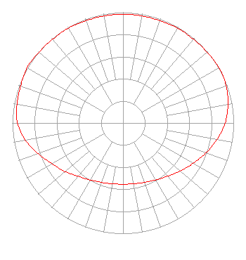 | ||||||||||||||||||
| Azimuth | Ratio | Azimuth | Ratio | Azimuth | Ratio | Azimuth | Ratio | ||||||||||||
| 0 | 0.983 | 10 | 0.983 | 20 | 0.983 | 30 | 0.988 | ||||||||||||
| 40 | 0.988 | 50 | 0.992 | 60 | 1.000 | 70 | 0.991 | ||||||||||||
| 80 | 0.963 | 90 | 0.923 | 100 | 0.862 | 110 | 0.797 | ||||||||||||
| 120 | 0.731 | 130 | 0.676 | 140 | 0.628 | 150 | 0.594 | ||||||||||||
| 160 | 0.571 | 170 | 0.558 | 180 | 0.553 | 190 | 0.558 | ||||||||||||
| 200 | 0.571 | 210 | 0.594 | 220 | 0.628 | 230 | 0.682 | ||||||||||||
| 240 | 0.738 | 250 | 0.815 | 260 | 0.897 | 270 | 0.953 | ||||||||||||
| 280 | 0.973 | 290 | 0.983 | 300 | 1.000 | 310 | 0.992 | ||||||||||||
| 320 | 0.988 | 330 | 0.988 | 340 | 0.983 | 350 | 0.983 | ||||||||||||
Structure Registration Number 1009801 Structure Type: GTOWER Registered To: Pinnacle Towers LLC Structure Address: 1580 University Blvd Round Rock, TX County Name: Williamson County ASR Issued: 05/10/2021 Date Built: 01/10/1997 Site Elevation: 253 m (830 ft.) Structure Height: 134.7 m (442 ft.) Height Overall: 141.4 m (464 ft.) Overall Height AMSL: 394.4 m (1294 ft.) FAA Determination: 05/04/2021 FAA Study #: 2021-ASW-6425-OE FAA Circular #: 70/7460-1M Paint & Light FAA Chapters: 4, 8, 15 PRIOR STUDY 2018-ASW-18434-OE 30-34-13.0 N 97-39-25.8 W (NAD 83) 30-34-12.3 N 97-39-24.8 W (Converted to NAD 27) |
680 Barclay Boulevard Lincolnshire, IL 60069 Phone: 877-291-0123 Not-for-Profit | Title: Director Of Station Engineering Date: 10/06/2023 Application Certifier RELEVANT RADIO, INC. Relevant Radio, Inc. 680 Barclay Boulevard Lincolnshire, IL 60069 Applicant Bruce Bellamy Munn-reese Munn-reese Po Box 220 Coldwater, MI 49036 Consulting Engineer Mark Denbo Smithwick & Belendiuk, P.c. 5028 Wisconsin Avenue, N.w. Suite 301 Washington, DC 20016 Counsel | |||||||||||||||||