
FCCInfo.com
A Service of Cavell, Mertz & Associates, Inc.
(855) FCC-INFO
|
|
K271BP from 02/11/2009 K271BP from 03/12/2008 K271BP from 09/13/2004 |
|
|
||||||||||||||||
|
|
K271BP Channel: 271D 102.1 MHz Carmel, California Service: FX - A translator or application for a translator. Facility ID: 151853 Fac. Service: FX Programming Delivery Method: Unspecified Status: License Application Accepted: 10/06/2023 Application Granted: 10/13/2023 File Number: -0000222277 License Expires: 12/01/2029 Application Type: License To Cover FCC Website Links: LMS Facility Details This Application Other K271BP Applications Other K271BP Applications in CDBS Including Superseded Applications Mailing Address Correspondence for K271BP Correspondence related to application -0000222277 Service Contour - Open Street Map or USGS Map (60 dBu) Service Contour - KML / Google Earth (60 dBu) Facility Type: FM STATION Class: D, A Noncommercial educational operating with no more than 10W Site Location: 36-33-08.4 N 121-47-21.0 W (NAD 83) Site Location: 36-33-08.5 N 121-47-17.2 W (Converted to NAD 27) Effective Radiated Power: 0.099 kW Transmitter Output Power: 0.47 kW Antenna Center HAAT: 214.5 m Horiz.; 0 m Vert. Antenna Center AMSL: 390.2 m (1280 ft.) Antenna Center HAG: 15.8 m (52 ft.) Site Elevation: 374.4 m. (1228 ft.) Height Overall*: 23.8 m (78 ft.) (* As Filed In This Application, may differ from ASR Data, Below.) Directional Antenna Antenna Make/Model: Nicom BKG77 Antenna ID: 107022 Polarization: H
| ||||||||||||||||||
| Antenna Data for Antenna Id: 107022 K271BP FX File: -0000222277 Nicom - BKG77 Service: FX | 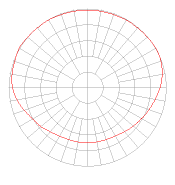 | ||||||||||||||||||
| Azimuth | Ratio | Azimuth | Ratio | Azimuth | Ratio | Azimuth | Ratio | ||||||||||||
| 0 | 0.983 | 10 | 0.983 | 20 | 0.983 | 30 | 0.988 | ||||||||||||
| 40 | 0.988 | 50 | 0.992 | 60 | 1.000 | 70 | 0.991 | ||||||||||||
| 80 | 0.963 | 90 | 0.923 | 100 | 0.873 | 110 | 0.832 | ||||||||||||
| 120 | 0.792 | 130 | 0.762 | 140 | 0.732 | 150 | 0.710 | ||||||||||||
| 160 | 0.702 | 170 | 0.702 | 180 | 0.702 | 190 | 0.702 | ||||||||||||
| 200 | 0.702 | 210 | 0.712 | 220 | 0.732 | 230 | 0.772 | ||||||||||||
| 240 | 0.802 | 250 | 0.853 | 260 | 0.909 | 270 | 0.953 | ||||||||||||
| 280 | 0.973 | 290 | 0.983 | 300 | 1.000 | 310 | 0.992 | ||||||||||||
| 320 | 0.988 | 330 | 0.988 | 340 | 0.983 | 350 | 0.983 | ||||||||||||
Structure Registration Number 1216884 Structure Type: 3GTA3 Registered To: HH TOWER GROUP LLC A CALIFORNIA LIMITED LIABILITY COMPANY Structure Address: 10805 Saddle Road Monterey, CA County Name: Monterey County ASR Issued: 10/31/2018 Date Built: 10/12/2014 Site Elevation: 374.4 m (1228 ft.) Structure Height: 23.1 m (76 ft.) Height Overall: 23.8 m (78 ft.) Overall Height AMSL: 398.2 m (1306 ft.) FAA Determination: 10/08/2014 FAA Study #: 2014-AWP-6398-OE Paint & Light FAA Chapters: NONE 36-33-08.4 N 121-47-21.0 W (NAD 83) 36-33-08.5 N 121-47-17.2 W (Converted to NAD 27) |
680 Barclay Boulevard Lincolnshire, IL 60069 Phone: 877-291-0123 Not-for-Profit | Title: Director Of Station Engineering Date: 10/06/2023 Application Certifier Relevant Radio, Inc. Relevant Radio, Inc. 680 Barclay Boulevard Lincolnshire, IL 60069 Applicant Mark Denbo Smithwick & Belendiuk, P.c. 5028 Wisconsin Avenue, N.w. Suite 301 Washington, DC 20016 Counsel | |||||||||||||||||