
FCCInfo.com
A Service of Cavell, Mertz & Associates, Inc.
(855) FCC-INFO
|
|
|
|
|
||||||||||||||||
|
|
K294AS Channel: 294D 106.7 MHz Ashland, Oregon Service: FX - A translator or application for a translator. Facility ID: 77759 Fac. Service: FX Programming Delivery Method: Unspecified Status: License Application Accepted: 10/12/2023 Application Granted: 10/18/2023 File Number: -0000222852 License Expires: 02/01/2030 Application Type: License To Cover FCC Website Links: LMS Facility Details This Application Other K294AS Applications Other K294AS Applications in CDBS Including Superseded Applications Mailing Address Correspondence for K294AS Correspondence related to application -0000222852 Service Contour - Open Street Map or USGS Map (60 dBu) Service Contour - KML / Google Earth (60 dBu) Facility Type: FM STATION Class: D, A Noncommercial educational operating with no more than 10W Site Location: 42-17-56.0 N 122-45-00.0 W (NAD 83) Site Location: 42-17-56.5 N 122-44-55.9 W (Converted to NAD 27) Effective Radiated Power: 0.07 kW Transmitter Output Power: 0.151 kW Antenna Center HAAT: 0 m Antenna Center AMSL: 1178 m (3865 ft.) Antenna Center HAG: 19.8 m (65 ft.) Site Elevation: 1158.2 m. (3800 ft.) Height Overall*: 35.1 m (115 ft.) (* As Filed In This Application, may differ from ASR Data, Below.) Directional Antenna Antenna Make/Model: Propagation System Inc PSIFMT-1A-6DB AT 300DEG Antenna ID: 118961 Polarization: H
| ||||||||||||||||||
| Antenna Data for Antenna Id: 118961 K294AS FX File: -0000222852 Propagation System Inc - PSIFMT-1A-6DB AT 300DEG Service: FX | 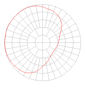 | ||||||||||||||||||
| Azimuth | Ratio | Azimuth | Ratio | Azimuth | Ratio | Azimuth | Ratio | ||||||||||||
| 0 | 0.932 | 10 | 0.889 | 20 | 0.860 | 30 | 0.811 | ||||||||||||
| 40 | 0.744 | 50 | 0.656 | 60 | 0.547 | 70 | 0.472 | ||||||||||||
| 80 | 0.443 | 90 | 0.415 | 100 | 0.395 | 110 | 0.378 | ||||||||||||
| 120 | 0.368 | 130 | 0.369 | 140 | 0.384 | 150 | 0.423 | ||||||||||||
| 160 | 0.475 | 170 | 0.545 | 180 | 0.628 | 190 | 0.745 | ||||||||||||
| 200 | 0.840 | 210 | 0.902 | 220 | 0.929 | 230 | 0.945 | ||||||||||||
| 240 | 0.966 | 250 | 0.981 | 260 | 0.986 | 270 | 0.988 | ||||||||||||
| 280 | 0.982 | 290 | 0.999 | 300 | 0.995 | 310 | 0.990 | ||||||||||||
| 320 | 0.996 | 330 | 1.000 | 340 | 0.994 | 350 | 0.971 | ||||||||||||
Structure Registration Number 1229102 Structure Type: TOWER Registered To: Mount Baldy Communication Site Leasing, LLC Structure Address: Mt. Baldy Medford, OR County Name: Jackson County ASR Issued: 10/12/2015 Date Built: 08/31/1999 Site Elevation: 1158.2 m (3800 ft.) Structure Height: 29.3 m (96 ft.) Height Overall: 35.1 m (115 ft.) Overall Height AMSL: 1193.3 m (3915 ft.) FAA Determination: 08/15/2001 FAA Study #: 01-ANM-2580-OE Paint & Light FAA Chapters: NONE Removed expiration date from determination. Scenario 1./jjs/case#635066 42-17-56.0 N 122-45-00.0 W (NAD 83) 42-17-56.5 N 122-44-55.9 W (Converted to NAD 27) |
1 Blackfield Drive # 333 Tiburon, CA 94920 Phone: 415-789-5035 Limited Liability Company | Title: Vice President And Chief Technology Officer Date: 10/12/2023 Application Certifier BICOASTAL MEDIA LICENSES VI, LLC Bicoastal Media Licenses Vi, Llc 1 Blackfield Drive # 333 Tiburon, CA 94920 Applicant ERIK C SWANSON, PE Hatfield & Dawson Hatfield & Dawson Consulting Engineers, 9500 Greenwood Ave N Seattle, WA 98103 CONSULTING ENGINEER MELODIE VIRTUE, ESQ Foster Garvey Pc 1000 Potomac Street, N.w. Suite 200 Washington, DC 20007 | |||||||||||||||||