
FCCInfo.com
A Service of Cavell, Mertz & Associates, Inc.
(855) FCC-INFO
|
|
WKGW from 11/22/2019 WKGW from 11/11/1992 WKGW from 08/31/1992 WKGW from 07/26/1991 |
|  |
|
|||||||||||||||
|
|
WAIV Channel: 219A 91.7 MHz Kingston, New York Service: FM - A full-service FM station or application. Facility ID: 20688 Fac. Service: FM Status: License Application Accepted: 10/17/2023 Application Granted: 10/18/2023 File Number: -0000223207 License Expires: 00/00/0000 Application Type: Channel Substitution/Community of License Change Call Sign Request FCC Website Links: LMS Facility Details This Application Other WAIV Applications Other WAIV Applications in CDBS Including Superseded Applications Mailing Address Correspondence for WAIV Correspondence related to application -0000223207 Service Contour - Open Street Map or USGS Map (60 dBu) Service Contour - KML / Google Earth (60 dBu) Public Inspection Files Facility Type: NON-COMMERCIAL EDUC. FM Class: A, A Zone I; I-A; or II station; with 0.1kW-6kW ERP and a class contour distance <=28km Site Location: 41-59-14.3 N 74-01-11.5 W (NAD 83) Site Location: 41-59-14.0 N 74-01-13.0 W (Converted to NAD 27) Effective Radiated Power: 0 kW Horiz. ; 1.2 kW Vert. Transmitter Output Power: 0.457 kW Antenna Center HAAT: 0 m Horiz.; 99 m Vert. Antenna Center AMSL: 0 m Horiz.; 219 m Vert. Antenna Center HAG: 0 m Horiz.; 55 m Vert. Calculated Site Elevation: m. Height Overall*: 67.1 m (220 ft.) (* As Filed In This Application, may differ from ASR Data, Below.) Directional Antenna Antenna Make/Model: Electronics Research Inc. P302-1-DA-SP Antenna ID: 14463 Polarization: | ||||||||||||||||||
| Antenna Data for Antenna Id: 14463 WAIV FM File: -0000223207 Electronics Research Inc. - P302-1-DA-SP Service: FM | 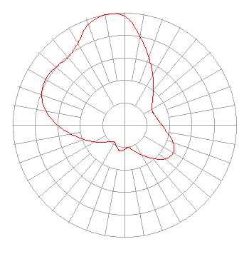 | ||||||||||||||||||
| Azimuth | Ratio | Azimuth | Ratio | Azimuth | Ratio | Azimuth | Ratio | ||||||||||||
| 0 | 0.968 | 10 | 0.797 | 20 | 0.635 | 30 | 0.506 | ||||||||||||
| 40 | 0.403 | 50 | 0.325 | 60 | 0.283 | 70 | 0.279 | ||||||||||||
| 80 | 0.298 | 90 | 0.333 | 100 | 0.384 | 110 | 0.461 | ||||||||||||
| 120 | 0.503 | 130 | 0.471 | 140 | 0.389 | 150 | 0.310 | ||||||||||||
| 160 | 0.247 | 170 | 0.203 | 180 | 0.219 | 190 | 0.235 | ||||||||||||
| 200 | 0.206 | 210 | 0.178 | 220 | 0.192 | 230 | 0.241 | ||||||||||||
| 240 | 0.303 | 250 | 0.381 | 260 | 0.479 | 270 | 0.601 | ||||||||||||
| 280 | 0.715 | 290 | 0.786 | 300 | 0.813 | 310 | 0.798 | ||||||||||||
| 320 | 0.783 | 330 | 0.835 | 340 | 0.948 | 350 | 0.993 | ||||||||||||
Structure Registration Number 1006449 [ASR Heights Differ from WAIV Application] Structure Type: TOWER Registered To: Global Tower, LLC. through American Towers, LLC Structure Address: Halihan Hill 1.1 Km Ne Sawkill, NY County Name: Ulster County ASR Issued: 08/29/2014 Date Built: 04/01/1990 Site Elevation: 164.2 m (539 ft.) Structure Height: 60.9 m (200 ft.) Height Overall: 64.6 m (212 ft.) Overall Height AMSL: 228.8 m (751 ft.) FAA Determination: 05/16/2005 FAA Study #: 2005-AEA-1437-OE FAA Circular #: 70/7460-1K Paint & Light FAA Chapters: 4, 8, 12 PRIOR STUDY 1990-AEA-1789-OE 41-59-14.0 N 74-01-12.0 W (NAD 83) 41-59-13.7 N 74-01-13.5 W (Converted to NAD 27) |
5700 West Oaks Blvd. Rocklin, CA 95765 Phone: 916-251-1600 Not-for-Profit | Title: Vice President/signal Development Date: 10/17/2023 Application Certifier EDUCATIONAL MEDIA FOUNDATION Educational Media Foundation 5700 West Oaks Blvd. Rocklin, CA 95765 Applicant MARY O'CONNOR Wilkinson Barker Knauer, Llp 1800 M Street, N.w., Suite 800n Washington, DC 20036 JAMES TRAVIS Educational Media Foundation 5700 West Oaks Blvd Rocklin, CA 95765 FCC COMPLIANCE ENGINEER | |||||||||||||||||