
FCCInfo.com
A Service of Cavell, Mertz & Associates, Inc.
(855) FCC-INFO
|
|
|
|
|
||||||||||||||||
|
|
WTWH Channel: 202A 88.3 MHz Hazleton, Pennsylvania Service: FM - A full-service FM station or application. Facility ID: 766931 Fac. Service: FM Status: License Application Accepted: 04/19/2024 Application Granted: 04/30/2024 File Number: -0000243702 License Expires: 08/01/2030 Application Type: License To Cover FCC Website Links: LMS Facility Details This Application Other WTWH Applications Other WTWH Applications in CDBS Including Superseded Applications Mailing Address Correspondence for WTWH Correspondence related to application -0000243702 Service Contour - Open Street Map or USGS Map (60 dBu) Service Contour - KML / Google Earth (60 dBu) Public Inspection Files Facility Type: NON-COMMERCIAL EDUC. FM Class: A, A Zone I; I-A; or II station; with 0.1kW-6kW ERP and a class contour distance <=28km Site Location: 40-51-00.0 N 76-06-54.6 W (NAD 83) Site Location: 40-50-59.7 N 76-06-55.8 W (Converted to NAD 27) Effective Radiated Power: 0.4 kW Antenna Center HAAT: 247 m (810 ft.) Antenna Center AMSL: 665 m (2182 ft.) Antenna Center HAG: 73 m (240 ft.) Site Elevation: 592 m. (1942 ft.) Height Overall*: 90 m (295 ft.) (* As Filed In This Application, may differ from ASR Data, Below.) Directional Antenna Antenna Make/Model: Propagation Systems Inc PSIM3Y Custom Antenna ID: 1011639 Polarization: | ||||||||||||||||||
| Antenna Data for Antenna Id: 1011639 WTWH FM File: -0000243702 Propagation Systems Inc - PSIM3Y Custom Service: FM | 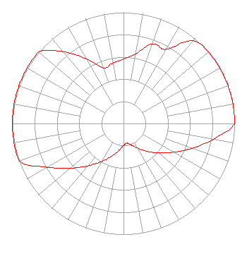 | ||||||||||||||||||
| Azimuth | Ratio | Azimuth | Ratio | Azimuth | Ratio | Azimuth | Ratio | ||||||||||||
| 0 | 0.578 | 10 | 0.637 | 20 | 0.762 | 30 | 0.770 | ||||||||||||
| 40 | 0.970 | 50 | 1.000 | 60 | 1.000 | 70 | 1.000 | ||||||||||||
| 80 | 1.000 | 90 | 1.000 | 100 | 0.822 | 110 | 0.653 | ||||||||||||
| 120 | 0.519 | 130 | 0.412 | 140 | 0.327 | 150 | 0.260 | ||||||||||||
| 160 | 0.207 | 170 | 0.180 | 180 | 0.198 | 190 | 0.250 | ||||||||||||
| 200 | 0.314 | 210 | 0.396 | 220 | 0.498 | 230 | 0.627 | ||||||||||||
| 240 | 0.790 | 250 | 0.994 | 260 | 1.000 | 270 | 1.000 | ||||||||||||
| 280 | 1.000 | 290 | 1.000 | 300 | 1.000 | 310 | 1.000 | ||||||||||||
| 320 | 0.844 | 330 | 0.670 | 340 | 0.532 | 350 | 0.551 | ||||||||||||
Structure Registration Number 1025752 Structure Type: TOWER Registered To: Octagon Towers, LLC Structure Address: Park Place Road Mahanoy City, PA County Name: Schuylkill County ASR Issued: 12/31/2020 Date Built: 09/15/1994 Site Elevation: 591.6 m (1941 ft.) Structure Height: 86.9 m (285 ft.) Height Overall: 89.6 m (294 ft.) Overall Height AMSL: 681.2 m (2235 ft.) FAA Determination: 02/27/2009 FAA Study #: 2009-AEA-431-OE FAA Circular #: 70/7460-1K Paint & Light FAA Chapters: 4, 8, 12 PRIOR STUDY 1996-AEA-1518-OE 40-51-00.0 N 76-06-54.6 W (NAD 83) 40-50-59.7 N 76-06-55.8 W (Converted to NAD 27) |
1815 Colebrook Road Lebanon, PA 17042 Phone: 717-507-5633 Not-for-Profit | Title: President Date: 04/19/2024 Application Certifier Calvary Chapel Bible Broadcasting 1815 Colebrook Road Lebanon, PA 17042 Applicant Robert Moore Rcm Enterprises 1908 Sweetbriar Goshen, IN 46528 Kathleen Victory, FCC Counsel Fletcher, Heald & Hildreth, Plc 1300 North 17th Street Suite 1100 Arlington, VA 22209 | |||||||||||||||||