
FCCInfo.com
A Service of Cavell, Mertz & Associates, Inc.
(855) FCC-INFO
|
|
|
|
|
||||||||||||||||
|
|
K284CY Channel: 284D 104.7 MHz Boise, Idaho Service: FX - A translator or application for a translator. Facility ID: 203207 Fac. Service: FX Programming Delivery Method: Unspecified Status: Construction Permit Application Accepted: 12/26/2023 Application Granted: 01/18/2024 File Number: -0000234027 K284CY CP Expires: 04/21/2025 Application Type: Minor Modification FCC Website Links: LMS Facility Details This Application Other K284CY Applications Other K284CY Applications in CDBS Including Superseded Applications Mailing Address Correspondence for K284CY Correspondence related to application -0000234027 Service Contour - Open Street Map or USGS Map (60 dBu) Service Contour - KML / Google Earth (60 dBu) Facility Type: FM STATION Class: D, A Noncommercial educational operating with no more than 10W Site Location: 43-45-15.6 N 116-05-59.4 W (NAD 83) Site Location: 43-45-16.0 N 116-05-56.0 W (Converted to NAD 27) Effective Radiated Power: 0.099 kW Antenna Center HAAT: 0 m Antenna Center AMSL: 2157.5 m (7078 ft.) Antenna Center HAG: 30 m (98 ft.) Site Elevation: 2127.5 m. (6980 ft.) Height Overall*: 68.9 m (226 ft.) (* As Filed In This Application, may differ from ASR Data, Below.) Directional Antenna Antenna Make/Model: Nicom BKG77 Antenna ID: 0 Polarization: H
| ||||||||||||||||||
| Antenna Data for Antenna Id: 0 K284CY FX File: -0000234027 Nicom - BKG77 Service: FX | 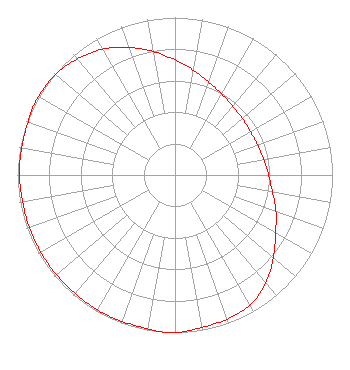 | ||||||||||||||||||
| Azimuth | Ratio | Azimuth | Ratio | Azimuth | Ratio | Azimuth | Ratio | ||||||||||||
| 0 | 0.731 | 10 | 0.676 | 20 | 0.628 | 30 | 0.594 | ||||||||||||
| 40 | 0.571 | 50 | 0.558 | 60 | 0.553 | 70 | 0.558 | ||||||||||||
| 80 | 0.571 | 90 | 0.594 | 100 | 0.628 | 110 | 0.682 | ||||||||||||
| 120 | 0.738 | 130 | 0.815 | 140 | 0.897 | 150 | 0.953 | ||||||||||||
| 160 | 0.973 | 170 | 0.983 | 180 | 1.000 | 185 | 1.000 | ||||||||||||
| 190 | 0.992 | 200 | 0.988 | 210 | 0.988 | 220 | 0.983 | ||||||||||||
| 230 | 0.983 | 240 | 0.983 | 250 | 0.983 | 260 | 0.983 | ||||||||||||
| 270 | 0.988 | 280 | 0.988 | 290 | 0.992 | 295 | 1.000 | ||||||||||||
| 300 | 1.000 | 310 | 0.991 | 320 | 0.963 | 330 | 0.923 | ||||||||||||
| 340 | 0.862 | 350 | 0.797 | ||||||||||||||||
Structure Registration Number 1213659 Structure Type: TOWER Registered To: King Broadcasting Company Structure Address: 10 3/4 Miles Nne Of Boise Boise, ID County Name: Boise County ASR Issued: 02/13/2019 Date Built: 10/10/1956 Site Elevation: 2127.5 m (6980 ft.) Structure Height: 45.7 m (150 ft.) Height Overall: 68.9 m (226 ft.) Overall Height AMSL: 2196.4 m (7206 ft.) FAA Determination: 08/23/1982 FAA Study #: 82-ANM-489-OE Paint & Light FAA Chapters: 1, 3, 11, 21 RED LIGHTS/PAINT. 43-45-15.6 N 116-05-59.4 W (NAD 83) 43-45-16.0 N 116-05-56.0 W (Converted to NAD 27) |
P.o. Box 490 Caldwell, ID 83606 Phone: 208-283-1441 Corporation | Title: President Date: 12/26/2023 Application Certifier IMPACTO NETWORK, INC. Impacto Network, Inc. P.o. Box 490 Caldwell, ID 83606 Applicant Dan J Alpert The Law Office Of Dan J. Alpert 2120 N. 21st Rd. Arlington, VA 22201 Legal Counsel Darryl K DeLawder Delawder Communications, Inc. P.o. Box 1095 Ashburn, VA 20146 President | |||||||||||||||||