
FCCInfo.com
A Service of Cavell, Mertz & Associates, Inc.
(855) FCC-INFO
|
|
KAWF from 06/02/2002 |
|
|
||||||||||||||||
|
|
KAWF Channel: 203B 88.5 MHz Selma, California Service: FM - A full-service FM station or application. Facility ID: 89071 Fac. Service: FM Status: Construction Permit Application Accepted: 02/06/2024 Application Granted: 02/29/2024 File Number: -0000238446 KAWF CP Expires: 02/28/2027 Application Type: Minor Modification FCC Website Links: LMS Facility Details This Application Other KAWF Applications Other KAWF Applications in CDBS Including Superseded Applications Mailing Address Correspondence for KAWF Correspondence related to application -0000238446 Service Contour - Open Street Map or USGS Map (60 dBu) Service Contour - KML / Google Earth (60 dBu) Public Inspection Files Facility Type: NON-COMMERCIAL EDUC. FM Class: B, A Zone I or I-A station; with 25kW-50kW ERP and a class contour distance 39km-52km Site Location: 36-12-16.0 N 119-33-56.0 W (NAD 83) Site Location: 36-12-16.2 N 119-33-52.6 W (Converted to NAD 27) Effective Radiated Power: 40 kW Antenna Center HAAT: 102 m (335 ft.) Antenna Center AMSL: 179 m (587 ft.) Antenna Center HAG: 110 m (361 ft.) Site Elevation: 69.2 m. (227 ft.) Height Overall*: 132.1 m (433 ft.) (* As Filed In This Application, may differ from ASR Data, Below.) Directional Antenna Antenna Make/Model: None Antenna ID: 45945 Polarization:
| ||||||||||||||||||
| Antenna Data for Antenna Id: 45945 KAWF FM File: -0000238446 None - Service: FM | 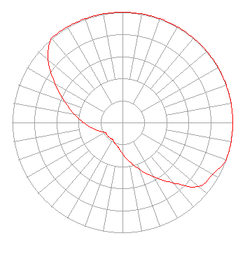 | ||||||||||||||||||
| Azimuth | Ratio | Azimuth | Ratio | Azimuth | Ratio | Azimuth | Ratio | ||||||||||||
| 0 | 1.000 | 10 | 1.000 | 20 | 1.000 | 30 | 1.000 | ||||||||||||
| 40 | 1.000 | 50 | 1.000 | 60 | 1.000 | 70 | 1.000 | ||||||||||||
| 80 | 1.000 | 90 | 1.000 | 100 | 1.000 | 110 | 1.000 | ||||||||||||
| 120 | 0.944 | 130 | 0.902 | 140 | 0.716 | 150 | 0.569 | ||||||||||||
| 160 | 0.452 | 170 | 0.359 | 180 | 0.285 | 190 | 0.227 | ||||||||||||
| 200 | 0.202 | 210 | 0.180 | 220 | 0.180 | 230 | 0.180 | ||||||||||||
| 240 | 0.182 | 250 | 0.224 | 260 | 0.282 | 270 | 0.355 | ||||||||||||
| 280 | 0.447 | 290 | 0.562 | 300 | 0.708 | 310 | 0.879 | ||||||||||||
| 320 | 1.000 | 330 | 1.000 | 340 | 1.000 | 350 | 1.000 | ||||||||||||
Structure Registration Number 1010998 Structure Type: TOWER Registered To: COLLANTES, ROLANDO DBA = KGEN RADIO POPULAR Structure Address: 6th Ave S Of Kansas St Approx 9 Mi Se Hanford, CA County Name: Kings County ASR Issued: 10/03/1997 Date Built: 12/31/1996 Site Elevation: 69.2 m (227 ft.) Structure Height: 131.2 m (430 ft.) Height Overall: 132.1 m (433 ft.) Overall Height AMSL: 201.3 m (660 ft.) FAA Determination: 06/23/1997 FAA Study #: 97-AWP-1040-OE FAA Circular #: 70/7460-1J Paint & Light FAA Chapters: 3, 4, 5, 13 PRIOR STUDY 96-AWP-1272-OE. 36-12-16.0 N 119-33-56.0 W (NAD 83) 36-12-16.2 N 119-33-52.6 W (Converted to NAD 27) |
5700 West Oaks Blvd Rocklin, CA 95765 Phone: 916-251-1600 Not-for-Profit | Title: Chief Financial Officer Date: 02/06/2024 Application Certifier EDUCATIONAL MEDIA FOUNDATION Educational Media Foundation 5700 West Oaks Blvd Rocklin, CA 95765 Applicant MARY O'CONNOR Wilkinson Barker Knauer, Llp 1800 M. Street, N.w., Suite 800n Washington, DC 20036 JAMES L TRAVIS Educational Media Foundation 5700 West Oaks Blvd Rocklin, CA 95765 FCC COMPLIANCE ENGINEER | |||||||||||||||||