
FCCInfo.com
A Service of Cavell, Mertz & Associates, Inc.
(855) FCC-INFO
|
|
|
|
|
||||||||||||||||
|
|
WPBD Channel: 203A 88.5 MHz Bainbridge, Georgia Service: FM - A full-service FM station or application. Facility ID: 765569 Fac. Service: FM Status: Construction Permit Application Accepted: 02/28/2024 Application Granted: 03/11/2024 File Number: -0000239948 WPBD CP Expires: 03/08/2025 Application Type: Minor Modification FCC Website Links: LMS Facility Details This Application Other WPBD Applications Other WPBD Applications in CDBS Including Superseded Applications Mailing Address Correspondence for WPBD Correspondence related to application -0000239948 Service Contour - Open Street Map or USGS Map (60 dBu) Service Contour - KML / Google Earth (60 dBu) Public Inspection Files Facility Type: NON-COMMERCIAL EDUC. FM Class: A, A Zone I; I-A; or II station; with 0.1kW-6kW ERP and a class contour distance <=28km Site Location: 31-02-27.0 N 84-39-19.8 W (NAD 83) Site Location: 31-02-26.3 N 84-39-20.1 W (Converted to NAD 27) Effective Radiated Power: 6 kW Antenna Center HAAT: 78 m (256 ft.) Antenna Center AMSL: 119 m (390 ft.) Antenna Center HAG: 79 m (259 ft.) Site Elevation: 39.3 m. (129 ft.) Height Overall*: 94.5 m (310 ft.) (* As Filed In This Application, may differ from ASR Data, Below.) Directional Antenna Antenna Make/Model: None Antenna ID: 1006063 Polarization: | ||||||||||||||||||
| Antenna Data for Antenna Id: 1006063 WPBD FM File: -0000239948 None - Service: FM | 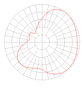 | ||||||||||||||||||
| Azimuth | Ratio | Azimuth | Ratio | Azimuth | Ratio | Azimuth | Ratio | ||||||||||||
| 0 | 0.620 | 10 | 0.780 | 20 | 0.911 | 30 | 0.980 | ||||||||||||
| 40 | 1.000 | 50 | 0.991 | 60 | 0.971 | 70 | 0.950 | ||||||||||||
| 80 | 0.935 | 90 | 0.932 | 100 | 0.945 | 110 | 0.965 | ||||||||||||
| 120 | 0.978 | 130 | 0.987 | 140 | 0.983 | 150 | 0.953 | ||||||||||||
| 160 | 0.896 | 170 | 0.816 | 180 | 0.722 | 190 | 0.700 | ||||||||||||
| 200 | 0.732 | 210 | 0.776 | 220 | 0.808 | 230 | 0.805 | ||||||||||||
| 240 | 0.754 | 250 | 0.658 | 260 | 0.529 | 270 | 0.420 | ||||||||||||
| 280 | 0.334 | 290 | 0.345 | 300 | 0.384 | 310 | 0.378 | ||||||||||||
| 320 | 0.300 | 330 | 0.330 | 340 | 0.396 | 350 | 0.498 | ||||||||||||
Structure Registration Number 1238872 Structure Type: TOWER Registered To: SBA Structures, LLC Structure Address: 1800 Old El Dorendo Rd. (ga21696-a) Colquitt, GA County Name: Decatur County ASR Issued: 04/26/2013 Date Built: 12/12/2003 Site Elevation: 39.3 m (129 ft.) Structure Height: 91.4 m (300 ft.) Height Overall: 94.5 m (310 ft.) Overall Height AMSL: 133.8 m (439 ft.) FAA Determination: 02/14/2004 FAA Study #: 2003-ASO-7195-OE FAA Circular #: 70/7460-1K Paint & Light FAA Chapters: 4, 8, 12 PRIOR STUDY 2003-ASO-1451-OE 31-02-27.0 N 84-39-19.8 W (NAD 83) 31-02-26.3 N 84-39-20.1 W (Converted to NAD 27) |
Gpb 260 14th St. Nw Atlanta, GA 30318 Phone: 404-685-2483 Government Entity | Title: Chief Operating Officer Date: 02/28/2024 Application Certifier Georgia Public Telecommunications Commission Gpb 260 14th St. Nw Atlanta, GA 30318 Applicant Barry S. Persh Gray Miller Persh Llp 2233 Wisconsin Ave., Nw Suite 226 Washington, DC 20007 William T. Godfrey, Jr Kessler And Gehman Associates, Inc. Kessler And Gehman Associates, Inc. 507-d Nw 60th Street Gainesville, FL 32607 Consulting Engineers Joshua Turiel Gray Miller Persh Llp 2233 Wisconsin Ave., Nw Suite 226 Washington, DC 20007 | |||||||||||||||||