
FCCInfo.com
A Service of Cavell, Mertz & Associates, Inc.
(855) FCC-INFO
|
|
|
|
|
||||||||||||||||
|
|
WNJQ Channel: 206A 89.1 MHz Washington, New Jersey Service: FM - A full-service FM station or application. Facility ID: 766775 Fac. Service: FM Status: License Application Accepted: 03/21/2024 Application Granted: 03/29/2024 File Number: -0000241604 License Expires: 06/01/2030 Application Type: License To Cover FCC Website Links: LMS Facility Details This Application Other WNJQ Applications Other WNJQ Applications in CDBS Including Superseded Applications Mailing Address Correspondence for WNJQ Correspondence related to application -0000241604 Service Contour - Open Street Map or USGS Map (60 dBu) Service Contour - KML / Google Earth (60 dBu) Public Inspection Files Facility Type: NON-COMMERCIAL EDUC. FM Class: A, A Zone I; I-A; or II station; with 0.1kW-6kW ERP and a class contour distance <=28km Site Location: 40-46-13.0 N 75-03-37.0 W (NAD 83) Site Location: 40-46-12.6 N 75-03-38.4 W (Converted to NAD 27) Effective Radiated Power: 0.001 kW Horiz. ; 0.15 kW Vert. Antenna Center HAAT: 306 m (1004 ft.) Antenna Center AMSL: 469 m (1539 ft.) Antenna Center HAG: 85 m (279 ft.) Site Elevation: 383.4 m. (1258 ft.) Height Overall*: 118.9 m (390 ft.) (* As Filed In This Application, may differ from ASR Data, Below.) Directional Antenna Antenna Make/Model: Shively 6025-1 Antenna ID: 1011135 Polarization: | ||||||||||||||||||
| Antenna Data for Antenna Id: 1011135 WNJQ FM File: -0000241604 Shively - 6025-1 Service: FM | 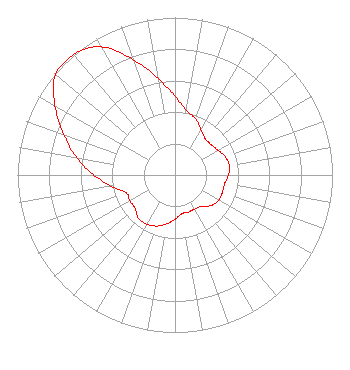 | ||||||||||||||||||
| Azimuth | Ratio | Azimuth | Ratio | Azimuth | Ratio | Azimuth | Ratio | ||||||||||||
| 0 | 0.500 | 10 | 0.415 | 20 | 0.380 | 30 | 0.330 | ||||||||||||
| 40 | 0.300 | 50 | 0.300 | 60 | 0.315 | 70 | 0.340 | ||||||||||||
| 80 | 0.350 | 90 | 0.340 | 100 | 0.320 | 110 | 0.320 | ||||||||||||
| 120 | 0.320 | 130 | 0.300 | 140 | 0.260 | 150 | 0.250 | ||||||||||||
| 160 | 0.250 | 170 | 0.250 | 180 | 0.280 | 190 | 0.315 | ||||||||||||
| 200 | 0.345 | 210 | 0.360 | 220 | 0.360 | 230 | 0.330 | ||||||||||||
| 240 | 0.330 | 250 | 0.330 | 260 | 0.410 | 270 | 0.515 | ||||||||||||
| 280 | 0.635 | 290 | 0.750 | 300 | 0.880 | 310 | 0.990 | ||||||||||||
| 320 | 1.000 | 330 | 0.940 | 340 | 0.780 | 350 | 0.620 | ||||||||||||
Structure Registration Number 1209893 Structure Type: LTOWER Registered To: Industrial Communications Company Structure Address: 977 Harmony Brass Castle Road Washington, NJ County Name: Warren County ASR Issued: 12/27/2017 Date Built: 11/30/1999 Site Elevation: 383.4 m (1258 ft.) Structure Height: 118.9 m (390 ft.) Height Overall: 118.9 m (390 ft.) Overall Height AMSL: 502.3 m (1648 ft.) FAA Determination: 03/13/2009 FAA Study #: 2008-AEA-4946-OE FAA Circular #: 70/7460-1K Paint & Light FAA Chapters: 4, 8, 12 PRIOR STUDY 2008-AEA-4947-OE 40-46-13.0 N 75-03-37.0 W (NAD 83) 40-46-12.6 N 75-03-38.4 W (Converted to NAD 27) |
158 W. Clinton Street Dover, NJ 07801 Phone: 973-659-3380 Not-for-Profit | Title: Sr. Pastor/president Date: 03/21/2024 Application Certifier Calvary Chapel Morris Hills 158 W. Clinton Street Dover, NJ 07801 Applicant Charles M. Anderson Anderson Associates 5900 Lake Cyrus Drive Hoover, AL 35244 BROADCAST ENGINEERING CONSULTANT Kathleen Victory Fletcher, Heald & Hildreth, P.l.c. 1300 North 17th Street Suite 1100 Arlington, VA 22209 Attorney | |||||||||||||||||