
FCCInfo.com
A Service of Cavell, Mertz & Associates, Inc.
(855) FCC-INFO
|
|
WABR from 03/20/1986 |
|
|
||||||||||||||||
|
|
WABR Channel: 216C2 91.1 MHz Tifton, Georgia Service: FM - A full-service FM station or application. Facility ID: 23925 Fac. Service: FM Analog & Digital Status: License Application Accepted: 04/17/2024 Application Granted: 04/24/2024 File Number: -0000243626 License Expires: 04/01/2028 Application Type: License To Cover FCC Website Links: LMS Facility Details This Application Other WABR Applications Other WABR Applications in CDBS Including Superseded Applications Mailing Address Correspondence for WABR Correspondence related to application -0000243626 Service Contour - Open Street Map or USGS Map (60 dBu) Service Contour - KML / Google Earth (60 dBu) Public Inspection Files Facility Type: NON-COMMERCIAL EDUC. FM Class: C2, A Zone II station; with 25kW-50kW ERP and a class contour distance 39km-52km Site Location: 31-29-30.6 N 83-31-48.1 W (NAD 83) Site Location: 31-29-29.9 N 83-31-48.5 W (Converted to NAD 27) Effective Radiated Power: 30 kW Transmitter Output Power: 5 kW Antenna Center HAAT: 76 m (249 ft.) Antenna Center AMSL: 173 m (568 ft.) Antenna Center HAG: 53 m (174 ft.) Site Elevation: 120.4 m. (395 ft.) Height Overall*: 75.9 m (249 ft.) (* As Filed In This Application, may differ from ASR Data, Below.) Directional Antenna Antenna Make/Model: Jampro JSLP-6 (DA) Antenna ID: 1011635 Polarization: | ||||||||||||||||||
| Antenna Data for Antenna Id: 1011635 WABR FM File: -0000243626 Jampro - JSLP-6 (DA) Service: FM | 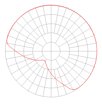 | ||||||||||||||||||
| Azimuth | Ratio | Azimuth | Ratio | Azimuth | Ratio | Azimuth | Ratio | ||||||||||||
| 0 | 1.000 | 10 | 1.000 | 20 | 1.000 | 30 | 1.000 | ||||||||||||
| 40 | 1.000 | 50 | 1.000 | 60 | 1.000 | 70 | 1.000 | ||||||||||||
| 80 | 1.000 | 90 | 1.000 | 100 | 1.000 | 110 | 1.000 | ||||||||||||
| 120 | 1.000 | 130 | 1.000 | 140 | 1.000 | 150 | 0.965 | ||||||||||||
| 160 | 0.770 | 170 | 0.615 | 180 | 0.490 | 190 | 0.390 | ||||||||||||
| 200 | 0.310 | 210 | 0.255 | 220 | 0.255 | 230 | 0.310 | ||||||||||||
| 240 | 0.390 | 250 | 0.490 | 260 | 0.615 | 270 | 0.770 | ||||||||||||
| 280 | 0.965 | 290 | 1.000 | 300 | 1.000 | 310 | 1.000 | ||||||||||||
| 320 | 1.000 | 330 | 1.000 | 340 | 1.000 | 350 | 1.000 | ||||||||||||
Structure Registration Number 1018784 Structure Type: GTOWER Registered To: Georgia Public Telecommunications Commission Structure Address: 2.9 Miles Nnw Of Tifton, On Zion Hope Road. Tifton, GA County Name: Tift County ASR Issued: 01/05/2024 Date Built: 06/01/1988 Site Elevation: 120.4 m (395 ft.) Structure Height: 75.9 m (249 ft.) Height Overall: 75.9 m (249 ft.) Overall Height AMSL: 196.3 m (644 ft.) FAA Determination: 11/08/2023 FAA Study #: 2023-ASO-29598-OE FAA Circular #: 70/7460-1M Paint & Light FAA Chapters: 4, 8, 15 31-29-30.6 N 83-31-48.1 W (NAD 83) 31-29-29.9 N 83-31-48.5 W (Converted to NAD 27) |
260 14th St Nw Atlanta, GA 30318 Phone: 404-685-2619 Government Entity | Title: Chief Operating Officer Date: 04/17/2024 Application Certifier GEORGIA PUBLIC TELECOMMUNICATIONS COMMISSION Georgia Public Telecommunications Commission 260 14th St Nw Atlanta, GA 30318 Applicant Joshua Turiel Gray Miller Persh Llp 2233 Wisconsin Avenue, Nw Suite 226 Washington, DC 20007 Barry S. Persh Gray Miller Persh Llp 2233 Wisconsin Ave., Nw Suite 226 Washington, DC 20007 Ryan C Wilhour Kessler And Gehman Associates, Inc. 14260 W Newberry Road #412 Newberry, FL 32669 Consulting Engineer | |||||||||||||||||