
FCCInfo.com
A Service of Cavell, Mertz & Associates, Inc.
(855) FCC-INFO
|
|
W269DE from 08/23/2012 W269DE from 10/07/2003 |
|
|
||||||||||||||||
|
|
W269DE Channel: 269D 101.7 MHz New Britain, Connecticut Service: FX - A translator or application for a translator. Facility ID: 143539 Fac. Service: FX Programming Delivery Method: Unspecified Status: License Application Accepted: 07/29/2020 Application Granted: 08/21/2020 File Number: -0000118873 License Expires: 04/01/2022 Application Type: License To Cover FCC Website Links: LMS Facility Details This Application Other W269DE Applications Other W269DE Applications in CDBS Including Superseded Applications Mailing Address Correspondence for W269DE Correspondence related to application -0000118873 Service Contour - Open Street Map or USGS Map (60 dBu) Service Contour - KML / Google Earth (60 dBu) Facility Type: FM STATION Class: D, A Noncommercial educational operating with no more than 10W Site Location: 41-42-58.4 N 72-48-35.4 W (NAD 83) Site Location: 41-42-58.0 N 72-48-37.0 W (Converted to NAD 27) Effective Radiated Power: 0.25 kW Antenna Center HAAT: 0 m Antenna Center AMSL: 202 m (663 ft.) Antenna Center HAG: 77 m (253 ft.) Site Elevation: 125 m. (410 ft.) Height Overall*: 85 m (279 ft.) (* As Filed In This Application, may differ from ASR Data, Below.) Directional Antenna Antenna Make/Model: Nicom BKG77/4 Antenna ID: 134268 Polarization: H
| ||||||||||||||||||
| Antenna Data for Antenna Id: 134268 W269DE FX File: -0000118873 Nicom - BKG77/4 Service: FX | 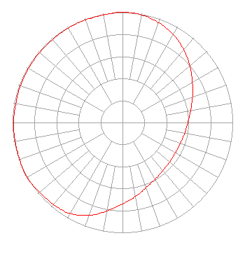 | ||||||||||||||||||
| Azimuth | Ratio | Azimuth | Ratio | Azimuth | Ratio | Azimuth | Ratio | ||||||||||||
| 0 | 1.000 | 10 | 0.991 | 20 | 0.963 | 30 | 0.923 | ||||||||||||
| 40 | 0.862 | 50 | 0.797 | 60 | 0.731 | 70 | 0.676 | ||||||||||||
| 80 | 0.628 | 90 | 0.594 | 100 | 0.571 | 110 | 0.558 | ||||||||||||
| 120 | 0.553 | 130 | 0.558 | 140 | 0.571 | 150 | 0.594 | ||||||||||||
| 160 | 0.628 | 170 | 0.682 | 180 | 0.738 | 190 | 0.815 | ||||||||||||
| 200 | 0.897 | 210 | 0.953 | 220 | 0.973 | 230 | 0.983 | ||||||||||||
| 240 | 1.000 | 250 | 0.992 | 260 | 0.988 | 270 | 0.988 | ||||||||||||
| 280 | 0.983 | 290 | 0.983 | 300 | 0.983 | 310 | 0.983 | ||||||||||||
| 320 | 0.983 | 330 | 0.988 | 340 | 0.988 | 350 | 0.992 | ||||||||||||
Structure Registration Number 1055559 [ASR Heights Differ from W269DE Application] Structure Type: 4GTA2 Registered To: Gois Broadcasting of Connecticut, LLC Structure Address: Twr 2 (night) - 130 Birdseye Rd Farmington, CT County Name: Hartford County ASR Issued: 09/21/2012 Date Built: 01/01/1945 Site Elevation: 125 m (410 ft.) Structure Height: 83.6 m (274 ft.) Height Overall: 84.5 m (277 ft.) Overall Height AMSL: 209.5 m (687 ft.) FAA Determination: 08/22/2012 FAA Study #: 2012-ANE-887-OE FAA Circular #: 70/7460-1K Paint & Light FAA Chapters: 3, 4, 5, 12 PRIOR STUDY 2003-ANE-357-OE 41-42-58.1 N 72-48-35.2 W (NAD 83) 41-42-57.7 N 72-48-36.8 W (Converted to NAD 27) |
135 Burnside Avenue East Hartford, CT 06108 Phone: 508-791-2111 Limited Liability Company | Title: Member Date: 07/29/2020 Application Certifier GOIS BROADCASTING OF CONNECTICUT, LLC Gois Broadcasting Of Connecticut, Llc 135 Burnside Avenue East Hartford, CT 06108 Applicant CHARLES A. Hecht Charles A. Hecht & Associates, Inc. Charles A. Hecht & Associates, Inc. 19 Mackenzie Court Freehold, NJ 07728 TECHNICAL CONSULTANT Allan G Moskowitz, Esq. Allan G. Moskowitz, Esq. 10845 Tuckahoe Way Allan G. Moskowitz, Esq. North Potomac, MD 20878 Attorney | |||||||||||||||||