
FCCInfo.com
A Service of Cavell, Mertz & Associates, Inc.
(855) FCC-INFO
|
|
|
|
|
||||||||||||||||
|
|
W297CG Channel: 297D 107.3 MHz Flint, Michigan Service: FX - A translator or application for a translator. Facility ID: 200852 Fac. Service: FX Programming Delivery Method: Unspecified Status: License Application Accepted: 10/14/2020 Application Granted: 11/09/2020 File Number: -0000124671 License Expires: 10/01/2028 Application Type: License To Cover FCC Website Links: LMS Facility Details This Application Other W297CG Applications Other W297CG Applications in CDBS Including Superseded Applications Mailing Address Correspondence for W297CG Correspondence related to application -0000124671 Service Contour - Open Street Map or USGS Map (60 dBu) Service Contour - KML / Google Earth (60 dBu) Facility Type: FM STATION Class: D, A Noncommercial educational operating with no more than 10W Site Location: 43-00-39.0 N 83-39-04.0 W (NAD 83) Site Location: 43-00-38.9 N 83-39-04.2 W (Converted to NAD 27) Effective Radiated Power: 0.25 kW Antenna Center HAAT: 0 m Antenna Center AMSL: 325.5 m (1068 ft.) Antenna Center HAG: 96 m (315 ft.) Site Elevation: 229.5 m. (753 ft.) Height Overall*: 111.9 m (367 ft.) (* As Filed In This Application, may differ from ASR Data, Below.) Directional Antenna Antenna Make/Model: NiCom BKG77-1 Antenna ID: 130448 Polarization: H
| ||||||||||||||||||
| Antenna Data for Antenna Id: 130448 W297CG FX File: -0000124671 NiCom - BKG77-1 Service: FX | 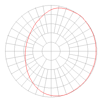 | ||||||||||||||||||
| Azimuth | Ratio | Azimuth | Ratio | Azimuth | Ratio | Azimuth | Ratio | ||||||||||||
| 0 | 0.897 | 10 | 0.953 | 20 | 0.973 | 30 | 0.983 | ||||||||||||
| 40 | 1.000 | 50 | 0.992 | 60 | 0.988 | 70 | 0.988 | ||||||||||||
| 80 | 0.983 | 90 | 0.983 | 100 | 0.983 | 110 | 0.983 | ||||||||||||
| 120 | 0.983 | 130 | 0.988 | 140 | 0.988 | 150 | 0.992 | ||||||||||||
| 160 | 1.000 | 170 | 0.991 | 180 | 0.963 | 190 | 0.923 | ||||||||||||
| 200 | 0.862 | 210 | 0.797 | 220 | 0.731 | 230 | 0.676 | ||||||||||||
| 240 | 0.628 | 250 | 0.594 | 260 | 0.571 | 270 | 0.558 | ||||||||||||
| 280 | 0.553 | 290 | 0.558 | 300 | 0.571 | 310 | 0.594 | ||||||||||||
| 320 | 0.628 | 330 | 0.682 | 340 | 0.738 | 350 | 0.815 | ||||||||||||
Structure Registration Number 1010841 Structure Type: 2TOWER Registered To: VB Nimbus, LLC Structure Address: 3217 Lapeer Rd Flint, MI County Name: Genesee County ASR Issued: 10/13/2020 Date Built: 01/01/1964 Site Elevation: 229.5 m (753 ft.) Structure Height: 110.9 m (364 ft.) Height Overall: 111.9 m (367 ft.) Overall Height AMSL: 341.4 m (1120 ft.) FAA Determination: 12/10/1996 FAA Study #: 96-AGL-3948-OE Paint & Light FAA Chapters: 1, 3, 12, 21 43-00-39.0 N 83-39-04.0 W (NAD 83) 43-00-38.9 N 83-39-04.2 W (Converted to NAD 27) |
3280 Peachtree Road, Nw Suite 2200 Atlanta, GA 30305 Phone: 404-949-0700 Limited Liability Company | Title: Executive Vice President And General Counsel Date: 10/14/2020 Application Certifier CUMULUS LICENSING LLC Cumulus Licensing Llc 3280 Peachtree Road, Nw Suite 2200 Atlanta, GA 30305 Applicant William J. Getz Carl T. Jones Corporation 7901 Yarnwood Ct Springfield, VA 22153 Consulting Engineer Mark Lipp Fletcher Heald & Hildreth Plc 1300 N. 17th Street Suite 1100 Arlington, VA 22209 | |||||||||||||||||