
FCCInfo.com
A Service of Cavell, Mertz & Associates, Inc.
(855) FCC-INFO
|
|
KVCI from 07/23/2008 |
|  |
|
|||||||||||||||
|
|
KVCI Channel: 209C1 89.7 MHz Montezuma, Iowa Service: FM - A full-service FM station or application. Facility ID: 173311 Fac. Service: FM Status: License Application Accepted: 11/03/2020 Application Granted: 12/04/2020 File Number: -0000124438 License Expires: 02/01/2021 Application Type: Amendment FCC Website Links: LMS Facility Details This Application Other KVCI Applications Other KVCI Applications in CDBS Including Superseded Applications Mailing Address Correspondence for KVCI Correspondence related to application -0000124438 Service Contour - Open Street Map or USGS Map (60 dBu) Service Contour - KML / Google Earth (60 dBu) Public Inspection Files Facility Type: NON-COMMERCIAL EDUC. FM Class: C1, A Zone II station; with 50kW-100kW ERP and a class contour distance 52km-72km Site Location: 41-12-14.0 N 92-51-07.7 W (NAD 83) Site Location: 41-12-14.0 N 92-51-07.0 W (Converted to NAD 27) Effective Radiated Power: 100 kW Antenna Center HAAT: 151 m (495 ft.) Antenna Center AMSL: 392 m (1286 ft.) Antenna Center HAG: 140 m (459 ft.) Calculated Site Elevation: 252 m. (827 ft.) Height Overall*: 152 m (499 ft.) (* As Filed In This Application, may differ from ASR Data, Below.) Directional Antenna Antenna Make/Model: Propogation Systems, Inc. PSIFMRH-10C-R-DA Antenna ID: 134910 Polarization: | ||||||||||||||||||
| Antenna Data for Antenna Id: 134910 KVCI FM File: -0000124438 Propogation Systems, Inc. - PSIFMRH-10C-R-DA Service: FM Pattern and Field Values Include a 240° Clockwise Rotation | 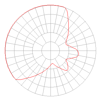 | ||||||||||||||||||
| Azimuth | Ratio | Azimuth | Ratio | Azimuth | Ratio | Azimuth | Ratio | ||||||||||||
| 0 | 1.000 | 10 | 1.000 | 20 | 0.980 | 30 | 0.780 | ||||||||||||
| 40 | 0.620 | 50 | 0.495 | 60 | 0.395 | 70 | 0.375 | ||||||||||||
| 80 | 0.470 | 90 | 0.590 | 100 | 0.620 | 110 | 0.495 | ||||||||||||
| 120 | 0.395 | 130 | 0.495 | 140 | 0.565 | 150 | 0.450 | ||||||||||||
| 160 | 0.360 | 170 | 0.288 | 180 | 0.320 | 190 | 0.400 | ||||||||||||
| 200 | 0.500 | 210 | 0.625 | 220 | 0.785 | 230 | 0.980 | ||||||||||||
| 240 | 1.000 | 250 | 1.000 | 260 | 1.000 | 270 | 1.000 | ||||||||||||
| 280 | 1.000 | 290 | 1.000 | 300 | 1.000 | 310 | 1.000 | ||||||||||||
| 320 | 1.000 | 330 | 1.000 | 340 | 1.000 | 350 | 1.000 | ||||||||||||
Structure Registration Number 1310649 Structure Type: GTOWER Registered To: VCY America Inc. Structure Address: 440' From The Corner Of 310th St And Barrows Ave. At A Heading Of 224 Degrees. Bussey, IA County Name: Mahaska County ASR Issued: 06/04/2019 Date Built: 06/03/2020 Site Elevation: 252 m (827 ft.) Structure Height: 152.1 m (499 ft.) Height Overall: 152.1 m (499 ft.) Overall Height AMSL: 404.1 m (1326 ft.) FAA Determination: 05/28/2019 FAA Study #: 2019-ACE-3154-OE FAA Circular #: 70/7460-1L Paint & Light FAA Chapters: 3, 4, 5, 12 Removed expiration date from determination. Scenario 1./jjs/case#635066 41-12-13.5 N 92-51-07.7 W (NAD 83) 41-12-13.5 N 92-51-07.0 W (Converted to NAD 27) |
3434 West Kilbourn Avenue Milwaukee, WI 53208 Phone: 414-935-3000 Not-for-Profit | Title: Vice President Of Communications Date: 11/03/2020 Application Certifier Vcy America, Inc. 3434 West Kilbourn Avenue Milwaukee, WI 53208 Applicant Kathryne Dickerson, Esq Wiley Rein Llp 1776 K Street, N.w. Washington, DC 20006 CHARLES BURKHART Sterling Communications, Inc. P.o. Box 1877 Lafayette, GA 30728 TECHNICAL CONSULTANT | |||||||||||||||||