
FCCInfo.com
A Service of Cavell, Mertz & Associates, Inc.
(855) FCC-INFO
|
|
KLXD from 03/22/1993 KLXD from 06/28/1991 |
|
|
||||||||||||||||
|
|
KLXD Channel: 208B1 89.5 MHz Victorville, California Service: FM - A full-service FM station or application. Facility ID: 60139 Fac. Service: FM Status: License Application Accepted: 01/04/2021 Application Granted: 01/22/2021 File Number: -0000130434 License Expires: 12/01/2021 Application Type: License To Cover FCC Website Links: LMS Facility Details This Application Other KLXD Applications Other KLXD Applications in CDBS Including Superseded Applications Mailing Address Correspondence for KLXD Correspondence related to application -0000130434 Service Contour - Open Street Map or USGS Map (60 dBu) Service Contour - KML / Google Earth (60 dBu) Public Inspection Files Facility Type: NON-COMMERCIAL EDUC. FM Class: B1, A Zone I or I-A station; with 6kW-25kW ERP and a class contour distance 28km-39km Site Location: 34-36-44.1 N 117-17-32.7 W (NAD 83) Site Location: 34-36-44.1 N 117-17-29.5 W (Converted to NAD 27) Effective Radiated Power: 1.2 kW Transmitter Output Power: 1.297 kW Antenna Center HAAT: 432 m (1417 ft.) Antenna Center AMSL: 1342 m (4403 ft.) Antenna Center HAG: 13 m (43 ft.) Site Elevation: 1329 m. (4360 ft.) Height Overall*: 30 m (98 ft.) (* As Filed In This Application, may differ from ASR Data, Below.) Directional Antenna Antenna Make/Model: Electronics Research Inc. DA-1005-1B-SP,2 sections Antenna ID: 126626 Polarization: H | ||||||||||||||||||
| Antenna Data for Antenna Id: 126626 KLXD FM File: -0000130434 Electronics Research Inc. - DA-1005-1B-SP,2 sections Service: FM | 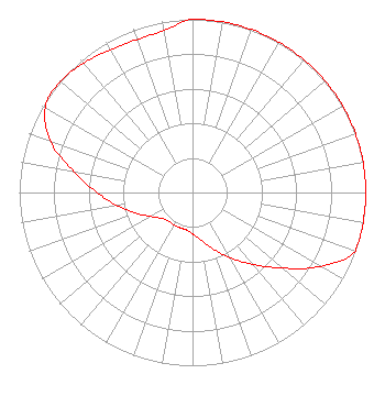 | ||||||||||||||||||
| Azimuth | Ratio | Azimuth | Ratio | Azimuth | Ratio | Azimuth | Ratio | ||||||||||||
| 0 | 1.000 | 10 | 1.000 | 20 | 1.000 | 30 | 1.000 | ||||||||||||
| 40 | 1.000 | 50 | 1.000 | 60 | 1.000 | 70 | 1.000 | ||||||||||||
| 80 | 1.000 | 90 | 1.000 | 100 | 1.000 | 110 | 1.000 | ||||||||||||
| 120 | 0.852 | 130 | 0.680 | 140 | 0.542 | 150 | 0.433 | ||||||||||||
| 160 | 0.346 | 170 | 0.278 | 180 | 0.239 | 190 | 0.219 | ||||||||||||
| 200 | 0.216 | 210 | 0.216 | 220 | 0.216 | 230 | 0.233 | ||||||||||||
| 240 | 0.278 | 250 | 0.349 | 260 | 0.439 | 270 | 0.552 | ||||||||||||
| 280 | 0.694 | 290 | 0.873 | 300 | 0.982 | 310 | 0.997 | ||||||||||||
| 320 | 0.977 | 330 | 0.950 | 340 | 0.939 | 350 | 0.950 | ||||||||||||
Structure Registration Number 1045372 Structure Type: LTOWER Registered To: EDUCATIONAL MEDIA FOUNDATION Structure Address: Quartzite Mountain, 3 Mi E Of Orogrande Victorville, CA County Name: San Bernardino County ASR Issued: 10/20/2020 Date Built: 10/20/2020 Site Elevation: 1329 m (4360 ft.) Structure Height: 30 m (98 ft.) Height Overall: 30 m (98 ft.) Overall Height AMSL: 1359 m (4459 ft.) FAA Determination: 09/28/2020 FAA Study #: 2020-AWP-10751-OE Paint & Light FAA Chapters: NONE PRIOR STUDY 1990-AWP-366-OE 34-36-44.1 N 117-17-32.7 W (NAD 83) 34-36-44.1 N 117-17-29.5 W (Converted to NAD 27) |
5700 West Oaks Blvd Rocklin, CA 95765 Phone: 916-251-1600 Not-for-Profit | Title: Ceo Date: 01/04/2021 Application Certifier EDUCATIONAL MEDIA FOUNDATION Educational Media Foundation 5700 West Oaks Blvd Rocklin, CA 95765 Applicant James L Travis Educational Media Foundation 5700 West Oaks Blvd Rocklin, CA 95765 FCC COMPLIANCE ENGINEER Mary O'Connor Wilkinson Barker Knauer, Llp 1800 M Street, N.w. Washington, CA 20036 Legal Representative | |||||||||||||||||