|
K268DW(FX)
Call Sign History
K268DW from 02/26/2021
K228FT from ???
K268DW from 02/26/2021
K228FT from 01/17/2018
|
101.5 MHz
|
King City, CA
|
|
K268DW Channel: 268D 101.5 MHz
King City, California
Service: FX - A translator or application for a translator.
Facility ID: 200412
FRN: 0024015505
Fac. Service: FX
Programming Delivery Method: Unspecified
Status: LIC
Application Accepted: 02/18/2021
Application Granted: 02/26/2021
File Number: 0000136486
License Expires: 12/01/2029
Application Type: License To Cover
FCC Website Links:
LMS Facility Details
This Application
Other K268DW Applications
Including Superseded Applications
Service Contour - Open Street Map or USGS Map (60 dBu)
Service Contour - KML / Google Earth (60 dBu)
Facility Type: FM STATION
Class: D, A Noncommercial educational operating with no more than 10W
Site Location: 36-22-58.8 N 121-25-43.9 W (NAD 83)
Site Location: 36-22-58.9 N 121-25-40.1 W (Converted to NAD 27)
Effective Radiated Power: 0.25 kW
Transmitter Output Power: 0.108 kW
Antenna Center AMSL: 949.3 m (3115 ft.)
Antenna Center HAG: 9 m (30 ft.)
Site Elevation: 940.3 m. (3085 ft.)
Height Overall*: 33.5 m (110 ft.)
(* As Filed In This Application, may differ from ASR Data, Below.)
Directional Antenna
Antenna Make/Model: SCALA CLFM-V 45 DEG SLANT
Antenna ID: 134481
Polarization: H
| Primary Station |
| KRKC(AM) |
Ch. 0 | King City, California |
|
Antenna Data for Antenna Id: 134481
K268DW FX File: -0000136486
SCALA - CLFM-V 45 DEG SLANT
Service: FX
|
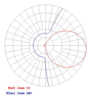 |
| Azimuth | Ratio | Azimuth | Ratio | Azimuth | Ratio | Azimuth | Ratio |
| 0 | 0.030 | 10 | 0.030 | 20 | 0.050 | 30 | 0.190 |
| 40 | 0.390 | 50 | 0.544 | 60 | 0.690 | 70 | 0.817 |
| 80 | 0.916 | 90 | 0.980 | 100 | 1.000 | 110 | 0.980 |
| 120 | 0.916 | 130 | 0.817 | 140 | 0.690 | 150 | 0.544 |
| 160 | 0.390 | 170 | 0.190 | 180 | 0.050 | 190 | 0.030 |
| 200 | 0.030 | 210 | 0.030 | 220 | 0.030 | 230 | 0.030 |
| 240 | 0.030 | 250 | 0.030 | 260 | 0.030 | 270 | 0.030 |
| 280 | 0.030 | 290 | 0.030 | 300 | 0.030 | 310 | 0.030 |
| 320 | 0.030 | 330 | 0.030 | 340 | 0.030 | 350 | 0.030 |
|
Structure Information
Structure Registration Number 1053794
Structure Type: TOWER
Registered To:
American Towers LLC
Structure Address:
37390 River Lane (soledad Peak T1 #8505)
Soledad, CA
County Name: Monterey County
ASR Issued: 01/15/2013
Date Built: 08/06/2001
Site Elevation: 940.3 m (3085 ft.)
Structure Height: 30.5 m (100 ft.)
Height Overall: 33.5 m (110 ft.)
Overall Height AMSL: 973.8 m (3195 ft.)
FAA Determination: 02/09/2005
FAA Study #: 2005-AWP-663-OE
Paint & Light FAA Chapters: NONE
Removed expiration date from determination. Scenario 1./jjs/case#635066
36-22-58.8 N 121-25-43.9 W (NAD 83)
36-22-58.9 N 121-25-40.1 W
(Converted to NAD 27)
|
K268DW(FX) Licensee Information
Dimes Media Corporation
149 Estaban Drive
Camarillo, CA 93010
Phone: 805-786-2570
Corporation | 0000136486 Applicant Information
William Gittler
Title: President
Date: 02/18/2021
Application Certifier
King City Communications Corporation
King City Communications Corporation
1134 San Antonio Drive
King City, CA 93930
Applicant
Charles M. Anderson
Anderson Associates
5900 Lake Cyrus Drive
Hoover, AL 35244
Engineering Consultant
|
Associated Land Mobile Licenses
|
| (No Records Found) |
| Associated Microwave Licenses
|
| (No Records Found) |
|
