
FCCInfo.com
A Service of Cavell, Mertz & Associates, Inc.
(855) FCC-INFO
|
|
W281CM from 10/26/2020 W281CM from 10/23/2013 |
|
|
||||||||||||||||
|
|
W281CM Channel: 281D 104.1 MHz Millville, New Jersey Service: FX - A translator or application for a translator. Facility ID: 138243 Fac. Service: FX Programming Delivery Method: Unspecified Status: License Application Accepted: 04/19/2021 Application Granted: 05/18/2021 File Number: -0000143669 License Expires: 06/01/2030 Application Type: License To Cover FCC Website Links: LMS Facility Details This Application Other W281CM Applications Other W281CM Applications in CDBS Including Superseded Applications Mailing Address Correspondence for W281CM Correspondence related to application -0000143669 Service Contour - Open Street Map or USGS Map (60 dBu) Service Contour - KML / Google Earth (60 dBu) Facility Type: FM STATION Class: D, A Noncommercial educational operating with no more than 10W Site Location: 39-41-43.3 N 75-17-53.5 W (NAD 83) Site Location: 39-41-42.9 N 75-17-54.8 W (Converted to NAD 27) Effective Radiated Power: 0.25 kW Transmitter Output Power: 0.144 kW Antenna Center HAAT: 0 m Antenna Center AMSL: 281.3 m (923 ft.) Antenna Center HAG: 256 m (840 ft.) Site Elevation: 25.3 m. (83 ft.) Height Overall*: 296.5 m (973 ft.) (* As Filed In This Application, may differ from ASR Data, Below.) Directional Antenna Antenna Make/Model: Propagation System Inc FML4A-FW-DA Antenna ID: 0 Polarization: H
| ||||||||||||||||||
| Antenna Data for Antenna Id: 0 W281CM FX File: -0000143669 Propagation System Inc - FML4A-FW-DA Service: FX | 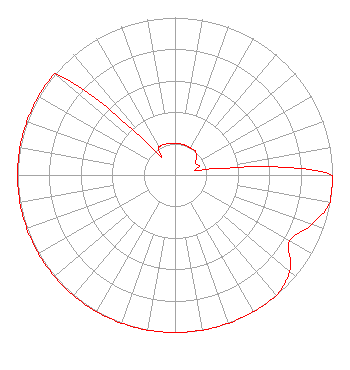 | ||||||||||||||||||
| Azimuth | Ratio | Azimuth | Ratio | Azimuth | Ratio | Azimuth | Ratio | ||||||||||||
| 0 | 0.201 | 10 | 0.200 | 20 | 0.199 | 30 | 0.197 | ||||||||||||
| 40 | 0.199 | 50 | 0.178 | 60 | 0.151 | 70 | 0.166 | ||||||||||||
| 80 | 0.198 | 90 | 1.000 | 100 | 1.000 | 110 | 0.922 | ||||||||||||
| 120 | 0.841 | 130 | 0.951 | 140 | 1.000 | 150 | 1.000 | ||||||||||||
| 160 | 1.000 | 170 | 1.000 | 180 | 1.000 | 190 | 1.000 | ||||||||||||
| 200 | 1.000 | 210 | 1.000 | 220 | 1.000 | 230 | 1.000 | ||||||||||||
| 240 | 1.000 | 250 | 1.000 | 260 | 1.000 | 270 | 1.000 | ||||||||||||
| 280 | 1.000 | 290 | 1.000 | 300 | 1.000 | 310 | 1.000 | ||||||||||||
| 320 | 0.204 | 330 | 0.206 | 340 | 0.207 | 350 | 0.201 | ||||||||||||
Structure Registration Number 1206729 Structure Type: TOWER Registered To: SpectraSite Communications, LLC. through American Towers, LLC. Structure Address: 79 Vestry Rd. ( 306734 ) Swedesboro, NJ County Name: Gloucester County ASR Issued: 01/15/2013 Date Built: 02/11/2008 Site Elevation: 25.3 m (83 ft.) Structure Height: 283.2 m (929 ft.) Height Overall: 296.5 m (973 ft.) Overall Height AMSL: 321.8 m (1056 ft.) FAA Determination: 10/20/2011 FAA Study #: 2011-AEA-3940-OE FAA Circular #: 70/7460-1K Paint & Light FAA Chapters: 4, 7, 12 PRIOR STUDY 2007-AEA-2850-OE 39-41-43.3 N 75-17-53.5 W (NAD 83) 39-41-42.9 N 75-17-54.8 W (Converted to NAD 27) |
1301 N. Harrison Street Wilmington, DE 19806 Phone: 000-000-0000 Limited Liability Company | Title: President Date: 04/19/2021 Application Certifier RITMO BROADCASTING, LLC. Ritmo Broadcasting, Llc. 2224 Federal St. Camden, NJ 08105 Applicant Charles Burkhart Sterling Communications, Inc. Lafayette, GA 30728 Technical Consultant James E. Price, III Sterling Communications, Inc. Lafayette, GA 30728 Legal Representative | |||||||||||||||||