
FCCInfo.com
A Service of Cavell, Mertz & Associates, Inc.
(855) FCC-INFO
|
|
|
|
|
||||||||||||||||
|
|
W295DG Channel: 295D 106.9 MHz Picayune, Mississippi Service: FX - A translator or application for a translator. Facility ID: 202626 Fac. Service: FX Programming Delivery Method: Unspecified Status: License Application Accepted: 05/19/2021 Application Granted: 06/16/2021 File Number: -0000146067 License Expires: 06/01/2028 Application Type: License To Cover FCC Website Links: LMS Facility Details This Application Other W295DG Applications Other W295DG Applications in CDBS Including Superseded Applications Mailing Address Correspondence for W295DG Correspondence related to application -0000146067 Service Contour - Open Street Map or USGS Map (60 dBu) Service Contour - KML / Google Earth (60 dBu) Facility Type: FM STATION Class: D, A Noncommercial educational operating with no more than 10W Site Location: 30-34-22.0 N 89-37-54.0 W (NAD 83) Site Location: 30-34-21.3 N 89-37-53.8 W (Converted to NAD 27) Effective Radiated Power: 0.25 kW Antenna Center HAAT: 0 m Antenna Center AMSL: 127 m (417 ft.) Antenna Center HAG: 95 m (312 ft.) Site Elevation: 32 m. (105 ft.) Height Overall*: 119.5 m (392 ft.) (* As Filed In This Application, may differ from ASR Data, Below.) Directional Antenna Antenna Make/Model: Nicom BKG-2-DA Antenna ID: 132224 Polarization: H
| ||||||||||||||||||
| Antenna Data for Antenna Id: 132224 W295DG FX File: -0000146067 Nicom - BKG-2-DA Service: FX | 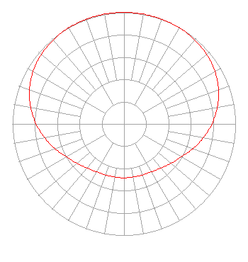 | ||||||||||||||||||
| Azimuth | Ratio | Azimuth | Ratio | Azimuth | Ratio | Azimuth | Ratio | ||||||||||||
| 0 | 1.000 | 10 | 1.000 | 20 | 0.997 | 30 | 0.994 | ||||||||||||
| 40 | 0.985 | 50 | 0.968 | 60 | 0.940 | 70 | 0.901 | ||||||||||||
| 80 | 0.849 | 90 | 0.788 | 100 | 0.722 | 110 | 0.656 | ||||||||||||
| 120 | 0.592 | 130 | 0.550 | 140 | 0.516 | 150 | 0.495 | ||||||||||||
| 160 | 0.487 | 170 | 0.483 | 180 | 0.484 | 190 | 0.483 | ||||||||||||
| 200 | 0.487 | 210 | 0.495 | 220 | 0.516 | 230 | 0.550 | ||||||||||||
| 240 | 0.592 | 250 | 0.656 | 260 | 0.722 | 270 | 0.788 | ||||||||||||
| 280 | 0.849 | 290 | 0.901 | 300 | 0.940 | 310 | 0.968 | ||||||||||||
| 320 | 0.985 | 330 | 0.994 | 340 | 0.997 | 350 | 1.000 | ||||||||||||
Structure Registration Number 1039930 Structure Type: TOWER Registered To: American Towers LLC Structure Address: 5.6 Km North Of I-59 & Sr-203 Picayune, MS County Name: Pearl River County ASR Issued: 12/28/2020 Date Built: 06/30/1994 Site Elevation: 32 m (105 ft.) Structure Height: 115.8 m (380 ft.) Height Overall: 119.5 m (392 ft.) Overall Height AMSL: 151.5 m (497 ft.) FAA Determination: 11/19/1991 FAA Study #: 91-ASO-1291-OE Paint & Light FAA Chapters: A2, H, 3, 4, 13, 21, 23 DUAL MEDIUM INTENSITY 30-34-22.0 N 89-37-54.0 W (NAD 83) 30-34-21.3 N 89-37-53.8 W (Converted to NAD 27) |
533 West Lakeshore Drive Carriere, MS 39426 Phone: 601-590-0179 Corporation | Title: President Date: 05/19/2021 Application Certifier PEARL RIVER COMMUNICATIONS, INC Pearl River Communications, Inc 533 West Lakeshore Drive Carriere, MS 39426 Applicant John Pigott Pearl River Communications, Inc P O Box 907 Picayune, MS 39466 Matthew Wesolowski Ssr Communications, Inc. 740 Hwy 49 Suite R Flora, MS 39071 Technical Consultant | |||||||||||||||||