
FCCInfo.com
A Service of Cavell, Mertz & Associates, Inc.
(855) FCC-INFO
|
|
WKVJ from 09/23/1998 |
|
|
||||||||||||||||
|
|
WKVJ Channel: 209C2 89.7 MHz Dannemora, New York Service: FM - A full-service FM station or application. Facility ID: 91724 Fac. Service: FM Status: License Application Accepted: 07/01/2021 Application Granted: 07/20/2021 File Number: -0000151436 License Expires: 06/01/2022 Application Type: License To Cover FCC Website Links: LMS Facility Details This Application Other WKVJ Applications Other WKVJ Applications in CDBS Including Superseded Applications Mailing Address Correspondence for WKVJ Correspondence related to application -0000151436 Service Contour - Open Street Map or USGS Map (60 dBu) Service Contour - KML / Google Earth (60 dBu) Public Inspection Files Facility Type: NON-COMMERCIAL EDUC. FM Class: C2, A Zone II station; with 25kW-50kW ERP and a class contour distance 39km-52km Site Location: 44-34-24.0 N 73-40-30.0 W (NAD 83) Site Location: 44-34-23.8 N 73-40-31.5 W (Converted to NAD 27) Effective Radiated Power: 5.2 kW Transmitter Output Power: 1.39 kW Antenna Center HAAT: 334 m (1096 ft.) Antenna Center AMSL: 640 m (2100 ft.) Antenna Center HAG: 36 m (118 ft.) Site Elevation: 604 m. (1982 ft.) Height Overall*: 48.7 m (160 ft.) (* As Filed In This Application, may differ from ASR Data, Below.) Directional Antenna Antenna Make/Model: Shively 6810-3R-DA Antenna ID: 69676 Polarization: | ||||||||||||||||||
| Antenna Data for Antenna Id: 69676 WKVJ FM File: -0000151436 Shively - 6810-3R-DA Service: FM | 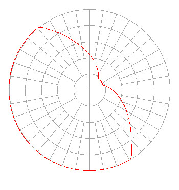 | ||||||||||||||||||
| Azimuth | Ratio | Azimuth | Ratio | Azimuth | Ratio | Azimuth | Ratio | ||||||||||||
| 0 | 0.437 | 10 | 0.351 | 20 | 0.279 | 30 | 0.223 | ||||||||||||
| 40 | 0.178 | 50 | 0.179 | 60 | 0.179 | 70 | 0.179 | ||||||||||||
| 80 | 0.225 | 90 | 0.282 | 100 | 0.354 | 110 | 0.431 | ||||||||||||
| 120 | 0.528 | 130 | 0.653 | 140 | 0.807 | 150 | 1.000 | ||||||||||||
| 160 | 1.000 | 170 | 1.000 | 180 | 1.000 | 190 | 1.000 | ||||||||||||
| 200 | 1.000 | 210 | 1.000 | 220 | 1.000 | 230 | 1.000 | ||||||||||||
| 240 | 1.000 | 250 | 1.000 | 260 | 1.000 | 270 | 1.000 | ||||||||||||
| 280 | 1.000 | 290 | 1.000 | 300 | 1.000 | 310 | 1.000 | ||||||||||||
| 320 | 1.000 | 330 | 0.828 | 340 | 0.664 | 350 | 0.540 | ||||||||||||
Structure Registration Number 1007293 [ASR Heights Differ from WKVJ Application] Structure Type: TOWER Registered To: County of Essex Structure Address: 1.8 Mi S Peasleeville, NY County Name: Clinton County ASR Issued: 02/28/2012 Date Built: 01/01/1978 Site Elevation: 603.5 m (1980 ft.) Structure Height: 48.7 m (160 ft.) Height Overall: 48.7 m (160 ft.) Overall Height AMSL: 652.2 m (2140 ft.) Paint & Light FAA Chapters: None 44-34-24.0 N 73-40-30.0 W (NAD 83) 44-34-23.8 N 73-40-31.5 W (Converted to NAD 27) |
5700 West Oaks Boulevard Rocklin, CA 95765 Phone: 916-251-1600 Not-for-Profit | Title: Ceo Date: 07/01/2021 Application Certifier EDUCATIONAL MEDIA FOUNDATION Educational Media Foundation 5700 West Oaks Boulevard Rocklin, CA 95765 Applicant James L Travis Educational Media Foundation 5700 West Oaks Blvd Rocklin, CA 95765 FCC COMPLIANCE ENGINEER MARY O'CONNOR Wilkinson Barker Knauer, Llp 1800 M Street, N.w. Suite 800n Washington, DC 20036 | |||||||||||||||||