
FCCInfo.com
A Service of Cavell, Mertz & Associates, Inc.
(855) FCC-INFO
|
|
|
|
|
||||||||||||||||
|
|
W285FT Channel: 285D 104.9 MHz Hazleton, Pennsylvania Service: FX - A translator or application for a translator. Facility ID: 201573 Fac. Service: FX Programming Delivery Method: Unspecified Status: License Application Accepted: 07/15/2021 Application Granted: 08/30/2021 File Number: -0000152975 License Expires: 08/01/2022 Application Type: License To Cover FCC Website Links: LMS Facility Details This Application Other W285FT Applications Other W285FT Applications in CDBS Including Superseded Applications Mailing Address Correspondence for W285FT Correspondence related to application -0000152975 Service Contour - Open Street Map or USGS Map (60 dBu) Service Contour - KML / Google Earth (60 dBu) Facility Type: FM STATION Class: D, A Noncommercial educational operating with no more than 10W Site Location: 40-58-08.2 N 75-57-25.1 W (NAD 83) Site Location: 40-58-07.9 N 75-57-26.4 W (Converted to NAD 27) Effective Radiated Power: 0.25 kW Antenna Center HAAT: 0 m Antenna Center AMSL: 606 m (1988 ft.) Antenna Center HAG: 30.5 m (100 ft.) Site Elevation: 575.5 m. (1888 ft.) Height Overall*: 55.2 m (181 ft.) (* As Filed In This Application, may differ from ASR Data, Below.) Directional Antenna Antenna Make/Model: Kathrein Scala CA5-FM/CP/RM Antenna ID: 130243 Polarization: H
| ||||||||||||||||||
| Antenna Data for Antenna Id: 130243 W285FT FX File: -0000152975 Kathrein Scala - CA5-FM/CP/RM Service: FX | 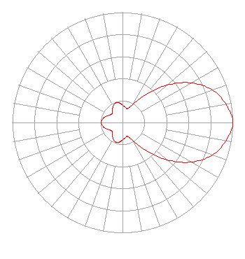 | ||||||||||||||||||
| Azimuth | Ratio | Azimuth | Ratio | Azimuth | Ratio | Azimuth | Ratio | ||||||||||||
| 0 | 0.157 | 10 | 0.142 | 20 | 0.134 | 30 | 0.190 | ||||||||||||
| 40 | 0.329 | 50 | 0.528 | 60 | 0.718 | 70 | 0.866 | ||||||||||||
| 80 | 0.952 | 90 | 1.000 | 100 | 0.952 | 110 | 0.866 | ||||||||||||
| 120 | 0.718 | 130 | 0.528 | 140 | 0.329 | 150 | 0.190 | ||||||||||||
| 160 | 0.134 | 170 | 0.142 | 180 | 0.157 | 190 | 0.181 | ||||||||||||
| 200 | 0.187 | 210 | 0.171 | 220 | 0.140 | 230 | 0.123 | ||||||||||||
| 240 | 0.135 | 250 | 0.160 | 260 | 0.182 | 270 | 0.193 | ||||||||||||
| 280 | 0.182 | 290 | 0.160 | 300 | 0.135 | 310 | 0.123 | ||||||||||||
| 320 | 0.140 | 330 | 0.171 | 340 | 0.187 | 350 | 0.181 | ||||||||||||
Structure Registration Number 1200466 Structure Type: LTOWER Registered To: CCATT LLC Structure Address: 11th And Thompson Hazelton, PA County Name: Luzerne County ASR Issued: 05/09/2016 Date Built: 06/15/2000 Site Elevation: 575.5 m (1888 ft.) Structure Height: 48.8 m (160 ft.) Height Overall: 55.2 m (181 ft.) Overall Height AMSL: 630.7 m (2069 ft.) FAA Determination: 09/14/2015 FAA Study #: 2015-AEA-3413-OE FAA Circular #: 70/7460-1K Paint & Light FAA Chapters: 4, 8, 12 PRIOR STUDY 2012-AEA-314-OE 40-58-08.2 N 75-57-25.1 W (NAD 83) 40-58-07.9 N 75-57-26.4 W (Converted to NAD 27) |
575 Grove Street Honesdale, PA 18431 Phone: 570-253-1616 Limited Partnership | Title: Manager Date: 07/15/2021 Application Certifier BOLD GOLD MEDIA WBS, L.P. Bold Gold Media Wbs, L.p. 575 Grove Street Honesdale, PA 18431 Applicant Mark Denbo Smithwick & Belendiuk, Pc 5028 Wisconsin Ave., Nw Suite 301 Washington, DC 20016 Charles Williamson Digital Radio Engineering, Inc. 135 White Bridge Rd. Middletown, NY 10940 Technical Consultant | |||||||||||||||||