
FCCInfo.com
A Service of Cavell, Mertz & Associates, Inc.
(855) FCC-INFO
|
|
|
|
|
||||||||||||||||
|
|
W223DB Channel: 223D 92.5 MHz Liberty, New York Service: FX - A translator or application for a translator. Facility ID: 200957 Fac. Service: FX Programming Delivery Method: Unspecified Status: License Application Accepted: 07/15/2021 Application Granted: 08/30/2021 File Number: -0000152985 License Expires: 06/01/2022 Application Type: License To Cover FCC Website Links: LMS Facility Details This Application Other W223DB Applications Other W223DB Applications in CDBS Including Superseded Applications Mailing Address Correspondence for W223DB Correspondence related to application -0000152985 Service Contour - Open Street Map or USGS Map (60 dBu) Service Contour - KML / Google Earth (60 dBu) Facility Type: FM STATION Class: D, A Noncommercial educational operating with no more than 10W Site Location: 41-48-04.2 N 74-47-03.5 W (NAD 83) Site Location: 41-48-03.9 N 74-47-04.9 W (Converted to NAD 27) Effective Radiated Power: 0.25 kW Antenna Center HAAT: 0 m Antenna Center AMSL: 719 m (2359 ft.) Antenna Center HAG: 61 m (200 ft.) Site Elevation: 658 m. (2159 ft.) Height Overall*: 96 m (315 ft.) (* As Filed In This Application, may differ from ASR Data, Below.) Directional Antenna Antenna Make/Model: Nicom BKG77 Antenna ID: 130244 Polarization: H
| ||||||||||||||||||
| Antenna Data for Antenna Id: 130244 W223DB FX File: -0000152985 Nicom - BKG77 Service: FX | 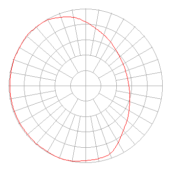 | ||||||||||||||||||
| Azimuth | Ratio | Azimuth | Ratio | Azimuth | Ratio | Azimuth | Ratio | ||||||||||||
| 0 | 0.830 | 10 | 0.756 | 20 | 0.699 | 30 | 0.653 | ||||||||||||
| 40 | 0.610 | 50 | 0.580 | 60 | 0.563 | 70 | 0.554 | ||||||||||||
| 80 | 0.554 | 90 | 0.563 | 100 | 0.583 | 110 | 0.610 | ||||||||||||
| 120 | 0.653 | 130 | 0.706 | 140 | 0.764 | 150 | 0.853 | ||||||||||||
| 160 | 0.939 | 170 | 0.963 | 180 | 0.973 | 190 | 0.993 | ||||||||||||
| 200 | 1.000 | 210 | 0.988 | 220 | 0.988 | 230 | 0.983 | ||||||||||||
| 240 | 0.983 | 250 | 0.983 | 260 | 0.983 | 270 | 0.983 | ||||||||||||
| 280 | 0.983 | 290 | 0.988 | 300 | 0.988 | 310 | 1.000 | ||||||||||||
| 320 | 0.993 | 330 | 0.983 | 340 | 0.943 | 350 | 0.900 | ||||||||||||
Structure Registration Number 1013992 Structure Type: TOWER Registered To: Goosetown Network Services, LLC Structure Address: 3.22 Km W Of Liberty Ny Loomis, NY County Name: Sullivan County ASR Issued: 09/07/2010 Date Built: 01/01/1966 Site Elevation: 658.4 m (2160 ft.) Structure Height: 91.4 m (300 ft.) Height Overall: 96 m (315 ft.) Overall Height AMSL: 754.4 m (2475 ft.) FAA Determination: 08/26/2010 FAA Study #: 2010-AEA-2813-OE Paint & Light FAA Chapters: A1, H, 3, 11, 21, 23 PRIOR STUDY 1996-AEA-2420-OE 41-48-04.2 N 74-47-03.5 W (NAD 83) 41-48-03.9 N 74-47-04.9 W (Converted to NAD 27) |
575 Grove Street Honesdale, PA 18431 Phone: 570-253-1616 Limited Partnership | Title: Manager Date: 07/15/2021 Application Certifier BOLD GOLD MEDIA GROUP, L.P. Bold Gold Media Group, L.p. 575 Grove Street Honesdale, PA 18431 Applicant Mark Denbo Smithwick & Belendiuk, P.c. 5028 Wisconsin Ave., Nw Suite 301 Washington, DC 20016 Charles Williamson Digital Radio Engineering, Inc. 15 Neversink Drive Port Jervis, NY 12771 TECHNICAL CONSULTANT | |||||||||||||||||