
FCCInfo.com
A Service of Cavell, Mertz & Associates, Inc.
(855) FCC-INFO
|
|
KLFK from 10/05/2021 |
|
|
||||||||||||||||
|
|
KLFK Channel: 254A 98.7 MHz Wells, Texas Service: FM - A full-service FM station or application. Facility ID: 762285 Fac. Service: FM Status: Construction Permit 73.215 Station Application Accepted: 08/27/2021 Application Granted: 10/05/2021 File Number: -0000158086 KLFK CP Expires: 10/05/2024 Application Type: Construction Permit FCC Website Links: LMS Facility Details This Application Other KLFK Applications Other KLFK Applications in CDBS Including Superseded Applications Mailing Address Correspondence for KLFK Correspondence related to application -0000158086 Service Contour - Open Street Map or USGS Map (60 dBu) Service Contour - KML / Google Earth (60 dBu) Public Inspection Files Facility Type: FM STATION Class: A, A Zone I; I-A; or II station; with 0.1kW-6kW ERP and a class contour distance <=28km Site Location: 31-27-49.9 N 94-53-22.5 W (NAD 83) Site Location: 31-27-49.2 N 94-53-21.7 W (Converted to NAD 27) Effective Radiated Power: 6 kW Antenna Center HAAT: 100 m (328 ft.) Antenna Center AMSL: 179 m (587 ft.) Antenna Center HAG: 86 m (282 ft.) Site Elevation: 93 m. (305 ft.) Height Overall*: 136.8 m (449 ft.) (* As Filed In This Application, may differ from ASR Data, Below.) Directional Antenna Antenna Make/Model: None Antenna ID: 69-2019-08-06 Polarization: | ||||||||||||||||||
| Antenna Data for Antenna Id: 69-2019-08-06 KLFK FM File: -0000158086 None - Service: FM | 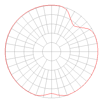 | ||||||||||||||||||
| Azimuth | Ratio | Azimuth | Ratio | Azimuth | Ratio | Azimuth | Ratio | ||||||||||||
| 0 | 1.000 | 10 | 1.000 | 20 | 0.953 | 30 | 0.821 | ||||||||||||
| 40 | 0.738 | 50 | 0.812 | 60 | 0.947 | 70 | 1.000 | ||||||||||||
| 80 | 1.000 | 90 | 1.000 | 100 | 1.000 | 110 | 1.000 | ||||||||||||
| 120 | 1.000 | 130 | 1.000 | 140 | 1.000 | 150 | 1.000 | ||||||||||||
| 160 | 1.000 | 170 | 0.953 | 180 | 0.906 | 190 | 0.955 | ||||||||||||
| 200 | 1.000 | 210 | 1.000 | 220 | 1.000 | 230 | 1.000 | ||||||||||||
| 240 | 1.000 | 250 | 1.000 | 260 | 1.000 | 270 | 1.000 | ||||||||||||
| 280 | 1.000 | 290 | 1.000 | 300 | 1.000 | 310 | 1.000 | ||||||||||||
| 320 | 1.000 | 330 | 1.000 | 340 | 1.000 | 350 | 1.000 | ||||||||||||
Structure Registration Number 1298736 Structure Type: GTOWER Registered To: Vertical Bridge S3 Assets, LLC Structure Address: Us Hwy 69 North ( Us-tx-5148 - Pollok) Pollock, TX County Name: Angelina County ASR Issued: 04/02/2018 Date Built: 06/28/2016 Site Elevation: 93 m (305 ft.) Structure Height: 135.6 m (445 ft.) Height Overall: 136.8 m (449 ft.) Overall Height AMSL: 229.8 m (754 ft.) FAA Determination: 01/28/2016 FAA Study #: 2016-ASW-228-OE FAA Circular #: 70/7460-1L Paint & Light FAA Chapters: 4, 8, 12 Removed expiration date from determination. Scenario 1./jjs/case#635066 31-27-49.9 N 94-53-22.5 W (NAD 83) 31-27-49.2 N 94-53-21.7 W (Converted to NAD 27) |
Phone: 254-757-1010 Individual | Title: Sole Proprietor Date: 08/27/2021 Application Certifier AMERICAN BROADCASTING OF TEXAS 1019 Washington Ave. Waco, TX 76701 Applicant MARK LIPP Fletcher, Heald & Hildreth, P.l.c. 1300 North 17th St 11th Floor Washington, DC 22209 ESQ STEVE WILLIAMS American Broadcasting Of Texas 1019 Washington Ave. Waco, TX 76701 SOLE PROPRIETOR PAUL LIERMAN, Lierman Self P.o. Box 18 Penney Farms, FL 32079 TECHNICAL CONSULTANT STEVE WILLIAMS American Broadcasting Of Texas 1019 Washington Ave. Waco, TX 76701 SOLE PROPRIETOR | |||||||||||||||||