
FCCInfo.com
A Service of Cavell, Mertz & Associates, Inc.
(855) FCC-INFO
|
|
|
|
|
||||||||||||||||
|
|
Channel: 203A 88.5 MHz Bloomington, Indiana Service: FM - A full-service FM station or application. Facility ID: 765034 Fac. Service: FM Status: Construction Permit Application Accepted: 11/03/2021 Application Pending: 11/03/2021 File Number: -0000165984 CP Expires: 00/00/0000 Application Type: Non-Commercial Educational New NCE FM CP FCC Website Links: LMS Facility Details This Application Other Applications Other Applications in CDBS Including Superseded Applications Mailing Address Correspondence for Correspondence related to application -0000165984 Service Contour - Open Street Map or USGS Map (60 dBu) Service Contour - KML / Google Earth (60 dBu) Facility Type: NON-COMMERCIAL EDUC. FM Class: A, A Zone I; I-A; or II station; with 0.1kW-6kW ERP and a class contour distance <=28km Site Location: 39-09-47.5 N 86-41-03.5 W (NAD 83) Site Location: 39-09-47.3 N 86-41-03.5 W (Converted to NAD 27) Effective Radiated Power: 3 kW Antenna Center HAAT: 107 m (351 ft.) Antenna Center AMSL: 333.1 m (1093 ft.) Antenna Center HAG: 120 m (394 ft.) Site Elevation: 213.1 m. (699 ft.) Height Overall*: 104.2 m (342 ft.) (* As Filed In This Application, may differ from ASR Data, Below.) Directional Antenna Antenna Make/Model: None Antenna ID: 69-2019-08-06 Polarization: | ||||||||||||||||||
| Antenna Data for Antenna Id: 69-2019-08-06 FM File: -0000165984 None - Service: FM | 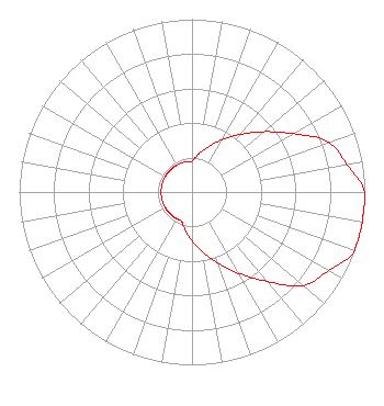 | ||||||||||||||||||
| Azimuth | Ratio | Azimuth | Ratio | Azimuth | Ratio | Azimuth | Ratio | ||||||||||||
| 0 | 0.179 | 10 | 0.224 | 20 | 0.281 | 30 | 0.350 | ||||||||||||
| 40 | 0.436 | 50 | 0.543 | 60 | 0.676 | 70 | 0.841 | ||||||||||||
| 80 | 0.912 | 90 | 1.000 | 100 | 1.000 | 110 | 1.000 | ||||||||||||
| 120 | 0.912 | 130 | 0.841 | 140 | 0.676 | 150 | 0.543 | ||||||||||||
| 160 | 0.436 | 170 | 0.350 | 180 | 0.281 | 190 | 0.224 | ||||||||||||
| 200 | 0.179 | 210 | 0.179 | 220 | 0.179 | 230 | 0.179 | ||||||||||||
| 240 | 0.179 | 250 | 0.179 | 260 | 0.179 | 270 | 0.179 | ||||||||||||
| 280 | 0.179 | 290 | 0.179 | 300 | 0.179 | 310 | 0.179 | ||||||||||||
| 320 | 0.179 | 330 | 0.179 | 340 | 0.179 | 350 | 0.179 | ||||||||||||
Structure Registration Number 1269543 Structure Type: TOWER Registered To: American Towers LLC Structure Address: Rr #1, Box 195-b (273230) Solsberry, IN County Name: Greene County ASR Issued: 01/15/2013 Date Built: 10/16/2009 Site Elevation: 213.1 m (699 ft.) Structure Height: 100.9 m (331 ft.) Height Overall: 104.2 m (342 ft.) Overall Height AMSL: 317.3 m (1041 ft.) FAA Determination: 12/09/2009 FAA Study #: 2009-AGL-5806-OE FAA Circular #: 70/7460-1K Paint & Light FAA Chapters: 4, 8, 12 OM&L to remain the same as prior study = A MED-DUAL SYSTEM 39-09-47.5 N 86-41-03.5 W (NAD 83) 39-09-47.3 N 86-41-03.5 W (Converted to NAD 27) |
Title: Executive Vice President Date: 11/03/2021 Application Certifier Olivet Nazarene University One University Avenue Bourbonnais, IL 60914 Applicant Jim Turvaville Turbo Tech Services 360 Patton Street - Po Box 144 Mobeetie, TX 79061 Cary S. Tepper Tepper Law Firm, Llc 4900 Auburn Avenue Suite 100 Bethesda, MD 20814-2632 Communications Counsel | ||||||||||||||||||