
FCCInfo.com
A Service of Cavell, Mertz & Associates, Inc.
(855) FCC-INFO
|
|
|
|
|
||||||||||||||||
|
|
W247AT Channel: 247D 97.3 MHz Huntsville, Alabama Service: FX - A translator or application for a translator. Facility ID: 157017 Fac. Service: FX Programming Delivery Method: Unspecified Status: Construction Permit (Licensed And Silent) Application Accepted: 10/25/2021 Application Granted: 10/26/2021 File Number: -0000157981 W247AT CP Expires: 10/26/2024 Application Type: Minor Amendment FCC Website Links: LMS Facility Details This Application Other W247AT Applications Other W247AT Applications in CDBS Including Superseded Applications Mailing Address Correspondence for W247AT Correspondence related to application -0000157981 Service Contour - Open Street Map or USGS Map (60 dBu) Service Contour - KML / Google Earth (60 dBu) Facility Type: FM STATION Class: D, A Noncommercial educational operating with no more than 10W Site Location: 34-44-12.8 N 86-31-58.9 W (NAD 83) Site Location: 34-44-12.5 N 86-31-58.9 W (Converted to NAD 27) Effective Radiated Power: 0.25 kW Antenna Center HAAT: 162.4 m Horiz.; 0 m Vert. Antenna Center AMSL: 680.1 m (2231 ft.) Antenna Center HAG: 207 m (679 ft.) Site Elevation: 473.1 m. (1552 ft.) Height Overall*: 305.4 m (1002 ft.) (* As Filed In This Application, may differ from ASR Data, Below.) Directional Antenna Antenna Make/Model: Nicom BLK5 Antenna ID: 0 Polarization: H
| ||||||||||||||||||
| Antenna Data for Antenna Id: 0 W247AT FX File: -0000157981 Nicom - BLK5 Service: FX | 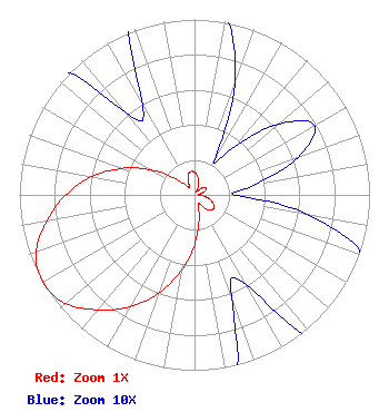 | ||||||||||||||||||
| Azimuth | Ratio | Azimuth | Ratio | Azimuth | Ratio | Azimuth | Ratio | ||||||||||||
| 0 | 0.128 | 10 | 0.105 | 20 | 0.067 | 30 | 0.023 | ||||||||||||
| 40 | 0.036 | 50 | 0.063 | 60 | 0.079 | 70 | 0.063 | ||||||||||||
| 80 | 0.036 | 90 | 0.023 | 100 | 0.067 | 110 | 0.105 | ||||||||||||
| 120 | 0.128 | 130 | 0.134 | 140 | 0.109 | 150 | 0.059 | ||||||||||||
| 160 | 0.062 | 170 | 0.150 | 180 | 0.285 | 190 | 0.441 | ||||||||||||
| 200 | 0.596 | 210 | 0.737 | 220 | 0.856 | 230 | 0.964 | ||||||||||||
| 240 | 1.000 | 250 | 0.964 | 260 | 0.856 | 270 | 0.737 | ||||||||||||
| 280 | 0.596 | 290 | 0.441 | 300 | 0.285 | 310 | 0.150 | ||||||||||||
| 320 | 0.062 | 330 | 0.059 | 340 | 0.109 | 350 | 0.134 | ||||||||||||
Structure Registration Number 1041008 Structure Type: GTOWER Registered To: American Towers, LLC Structure Address: 1000 Monte Sano Boulevard (#300152) Huntsville, AL County Name: Madison County ASR Issued: 02/07/2020 Date Built: 12/01/1977 Site Elevation: 473.1 m (1552 ft.) Structure Height: 274.3 m (900 ft.) Height Overall: 305.4 m (1002 ft.) Overall Height AMSL: 778.5 m (2554 ft.) FAA Determination: 04/24/2015 FAA Study #: 2015-ASO-2844-OE FAA Circular #: 70/7460-1K Paint & Light FAA Chapters: 4, 9, 12 PRIOR STUDY 2013-ASO-769-OE 34-44-12.8 N 86-31-58.9 W (NAD 83) 34-44-12.5 N 86-31-58.9 W (Converted to NAD 27)  American Tower Corporation 300152 - Huntsville 1008 |
Hoover, AL 35216 Phone: 205-612-8064 Individual | Title: Sole Proprietor Date: 10/25/2021 Application Certifier CAMERON P. REYNOLDS 4429 Cahaba River Boulevard Hoover, AL 35216 Applicant Cameron P Reynolds Cameron P. Reynolds, Individually 4429 Cahaba River Boulevard Hoover, AL 35216 | |||||||||||||||||