
FCCInfo.com
A Service of Cavell, Mertz & Associates, Inc.
(855) FCC-INFO
|
|
|
|
|
||||||||||||||||
|
|
Channel: 204C1 88.7 MHz Mankato, Minnesota Service: FM - A full-service FM station or application. Facility ID: 767545 Fac. Service: FM Status: Construction Permit Application Accepted: 11/09/2021 Application Granted: 02/24/2023 File Number: -0000167673 CP Expires: 02/24/2026 Application Type: Non-Commercial Educational New NCE FM CP FCC Website Links: LMS Facility Details This Application Other Applications Other Applications in CDBS Including Superseded Applications Mailing Address Correspondence for Correspondence related to application -0000167673 Service Contour - Open Street Map or USGS Map (60 dBu) Service Contour - KML / Google Earth (60 dBu) Facility Type: NON-COMMERCIAL EDUC. FM Class: C1, A Zone II station; with 50kW-100kW ERP and a class contour distance 52km-72km Site Location: 44-18-30.6 N 93-55-52.4 W (NAD 83) Site Location: 44-18-30.7 N 93-55-51.6 W (Converted to NAD 27) Effective Radiated Power: 54 kW Antenna Center HAAT: 83 m (272 ft.) Antenna Center AMSL: 374 m (1227 ft.) Antenna Center HAG: 70 m (230 ft.) Site Elevation: 304.5 m. (999 ft.) Height Overall*: 93.9 m (308 ft.) (* As Filed In This Application, may differ from ASR Data, Below.) Directional Antenna Antenna Make/Model: None Antenna ID: 69-2019-08-06 Polarization: | ||||||||||||||||||
| Antenna Data for Antenna Id: 69-2019-08-06 FM File: -0000167673 None - Service: FM | 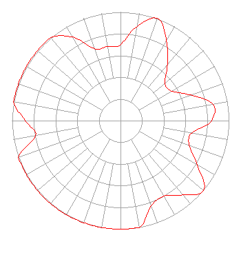 | ||||||||||||||||||
| Azimuth | Ratio | Azimuth | Ratio | Azimuth | Ratio | Azimuth | Ratio | ||||||||||||
| 0 | 0.700 | 10 | 0.881 | 20 | 1.000 | 30 | 0.848 | ||||||||||||
| 40 | 0.673 | 50 | 0.535 | 60 | 0.546 | 70 | 0.687 | ||||||||||||
| 80 | 0.865 | 90 | 0.839 | 100 | 0.667 | 110 | 0.674 | ||||||||||||
| 120 | 0.817 | 130 | 1.000 | 140 | 0.893 | 150 | 0.802 | ||||||||||||
| 160 | 0.835 | 170 | 1.000 | 180 | 1.000 | 190 | 1.000 | ||||||||||||
| 200 | 1.000 | 210 | 1.000 | 220 | 1.000 | 230 | 1.000 | ||||||||||||
| 240 | 1.000 | 250 | 1.000 | 260 | 0.794 | 270 | 0.877 | ||||||||||||
| 280 | 1.000 | 290 | 1.000 | 300 | 1.000 | 310 | 1.000 | ||||||||||||
| 320 | 1.000 | 330 | 0.888 | 340 | 0.705 | 350 | 0.692 | ||||||||||||
Structure Registration Number 1210658 Structure Type: TOWER Registered To: American Towers LLC Structure Address: 33169 County Rd. 107 (st. Peter #9295) Kasota, MN County Name: Le Sueur County ASR Issued: 01/15/2013 Date Built: 06/30/2000 Site Elevation: 304.5 m (999 ft.) Structure Height: 91.7 m (301 ft.) Height Overall: 93.9 m (308 ft.) Overall Height AMSL: 398.4 m (1307 ft.) FAA Determination: 10/02/2007 FAA Study #: 2007-AGL-6979-OE FAA Circular #: 70/7460-1J Paint & Light FAA Chapters: 4, 8, 13 OM&L to remain the same as prior study = A MED-DUAL SYSTEM 44-18-30.6 N 93-55-52.4 W (NAD 83) 44-18-30.7 N 93-55-51.6 W (Converted to NAD 27) |
65742 Highway 56 Dodge Center, MN 55927 Phone: 507-374-6761 Not-for-Profit | Title: President Date: 11/09/2021 Application Certifier One Day Church Project, Inc. 65742 Highway 56 Dodge Center, MN 55927 Applicant LUKE ROGERS Luke Rogers Consulting 1435 Woodland Ridge Road Odenville, AL 35120 DONALD MARTIN Law Office Of Donald E. Martin Falls Church, VA 22041 Attorney | |||||||||||||||||