
FCCInfo.com
A Service of Cavell, Mertz & Associates, Inc.
(855) FCC-INFO
|
|
|
|
|
||||||||||||||||
|
|
Channel: 216B1 91.1 MHz Chesterton, Indiana Service: FM - A full-service FM station or application. Facility ID: 767692 Fac. Service: FM Status: Construction Permit Application Accepted: 11/09/2021 Application Granted: 06/02/2022 File Number: -0000167842 CP Expires: 06/02/2025 Application Type: Non-Commercial Educational New NCE FM CP FCC Website Links: LMS Facility Details This Application Other Applications Other Applications in CDBS Including Superseded Applications Mailing Address Correspondence for Correspondence related to application -0000167842 Service Contour - Open Street Map or USGS Map (60 dBu) Service Contour - KML / Google Earth (60 dBu) Facility Type: NON-COMMERCIAL EDUC. FM Class: B1, A Zone I or I-A station; with 6kW-25kW ERP and a class contour distance 28km-39km Site Location: 41-36-22.0 N 87-02-36.0 W (NAD 83) Site Location: 41-36-21.9 N 87-02-35.9 W (Converted to NAD 27) Effective Radiated Power: 23.5 kW Antenna Center HAAT: 27 m (89 ft.) Antenna Center AMSL: 231 m (758 ft.) Antenna Center HAG: 34 m (112 ft.) Site Elevation: 197 m. (646 ft.) Height Overall*: 40 m (131 ft.) (* As Filed In This Application, may differ from ASR Data, Below.) Directional Antenna Antenna Make/Model: None Antenna ID: 69-2019-08-06 Polarization: | ||||||||||||||||||
| Antenna Data for Antenna Id: 69-2019-08-06 FM File: -0000167842 None - Service: FM | 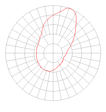 | ||||||||||||||||||
| Azimuth | Ratio | Azimuth | Ratio | Azimuth | Ratio | Azimuth | Ratio | ||||||||||||
| 0 | 0.789 | 10 | 0.880 | 20 | 1.000 | 30 | 0.941 | ||||||||||||
| 40 | 0.748 | 50 | 0.594 | 60 | 0.478 | 70 | 0.380 | ||||||||||||
| 80 | 0.314 | 90 | 0.285 | 100 | 0.270 | 110 | 0.245 | ||||||||||||
| 120 | 0.250 | 130 | 0.265 | 140 | 0.275 | 150 | 0.285 | ||||||||||||
| 160 | 0.300 | 170 | 0.335 | 180 | 0.360 | 190 | 0.390 | ||||||||||||
| 200 | 0.390 | 210 | 0.400 | 220 | 0.390 | 230 | 0.370 | ||||||||||||
| 240 | 0.370 | 250 | 0.360 | 260 | 0.355 | 270 | 0.345 | ||||||||||||
| 280 | 0.350 | 290 | 0.355 | 300 | 0.360 | 310 | 0.380 | ||||||||||||
| 320 | 0.425 | 330 | 0.475 | 340 | 0.600 | 350 | 0.700 | ||||||||||||
Structure Registration Number 1271716 Structure Type: MTOWER Registered To: SBA 2012 TC Assets, LLC Structure Address: 600 Porter Avenue (in 46586-a) Chesterton, IN County Name: Porter County ASR Issued: 11/22/2023 Date Built: 10/15/2001 Site Elevation: 197.2 m (647 ft.) Structure Height: 37.5 m (123 ft.) Height Overall: 39.6 m (130 ft.) Overall Height AMSL: 236.8 m (777 ft.) FAA Determination: 08/23/2023 FAA Study #: 2023-AGL-14355-OE Paint & Light FAA Chapters: NONE PRIOR STUDY 2014-AGL-9094-OE 41-36-22.1 N 87-02-35.6 W (NAD 83) 41-36-22.0 N 87-02-35.5 W (Converted to NAD 27) |
1207 Pine St Michigan City, IN 46360 Phone: 219-898-5743 Not-for-Profit | Title: Director Date: 11/09/2021 Application Certifier A Hand Up Inc 1207 Pine St Michigan City, IN 46360 Applicant John Parle John Parle Consulting Mountain View, AR 72560 | |||||||||||||||||