
FCCInfo.com
A Service of Cavell, Mertz & Associates, Inc.
(855) FCC-INFO
|
|
KCGO from 12/08/2022 |
|
|
||||||||||||||||
|
|
KCGO Channel: 210A 89.9 MHz Cabot, Arkansas Service: FM - A full-service FM station or application. Facility ID: 766333 Fac. Service: FM Status: Construction Permit Application Accepted: 11/08/2021 Application Granted: 11/28/2022 File Number: -0000165587 KCGO CP Expires: 11/28/2025 Application Type: Non-Commercial Educational Amendment FCC Website Links: LMS Facility Details This Application Other KCGO Applications Other KCGO Applications in CDBS Including Superseded Applications Mailing Address Correspondence for KCGO Correspondence related to application -0000165587 Service Contour - Open Street Map or USGS Map (60 dBu) Service Contour - KML / Google Earth (60 dBu) Public Inspection Files Facility Type: NON-COMMERCIAL EDUC. FM Class: A, A Zone I; I-A; or II station; with 0.1kW-6kW ERP and a class contour distance <=28km Site Location: 35-00-42.2 N 92-09-40.4 W (NAD 83) Site Location: 35-00-41.9 N 92-09-39.9 W (Converted to NAD 27) Effective Radiated Power: 1.7 kW Antenna Center HAAT: 128 m (420 ft.) Antenna Center AMSL: 235 m (771 ft.) Antenna Center HAG: 84 m (276 ft.) Site Elevation: 151.2 m. (496 ft.) Height Overall*: 104.8 m (344 ft.) (* As Filed In This Application, may differ from ASR Data, Below.) Directional Antenna Antenna Make/Model: None Antenna ID: 69-2019-08-06 Polarization: | ||||||||||||||||||
| Antenna Data for Antenna Id: 69-2019-08-06 KCGO FM File: -0000165587 None - Service: FM | 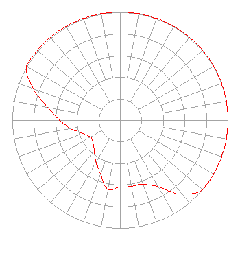 | ||||||||||||||||||
| Azimuth | Ratio | Azimuth | Ratio | Azimuth | Ratio | Azimuth | Ratio | ||||||||||||
| 0 | 1.000 | 10 | 1.000 | 20 | 1.000 | 30 | 1.000 | ||||||||||||
| 40 | 1.000 | 50 | 1.000 | 60 | 1.000 | 70 | 1.000 | ||||||||||||
| 80 | 1.000 | 90 | 1.000 | 100 | 1.000 | 110 | 1.000 | ||||||||||||
| 120 | 1.000 | 130 | 1.000 | 140 | 0.894 | 150 | 0.714 | ||||||||||||
| 160 | 0.630 | 170 | 0.622 | 180 | 0.620 | 190 | 0.646 | ||||||||||||
| 200 | 0.530 | 210 | 0.445 | 220 | 0.371 | 230 | 0.326 | ||||||||||||
| 240 | 0.313 | 250 | 0.364 | 260 | 0.458 | 270 | 0.560 | ||||||||||||
| 280 | 0.680 | 290 | 0.856 | 300 | 1.000 | 310 | 1.000 | ||||||||||||
| 320 | 1.000 | 330 | 1.000 | 340 | 1.000 | 350 | 1.000 | ||||||||||||
Structure Registration Number 1232807 Structure Type: TOWER Registered To: Pinnacle Towers Acquisition LLC Structure Address: 35715 Hwy 107 Cabot, AR County Name: Pulaski County ASR Issued: 05/06/2016 Date Built: 08/01/2002 Site Elevation: 151.2 m (496 ft.) Structure Height: 100 m (328 ft.) Height Overall: 104.8 m (344 ft.) Overall Height AMSL: 256 m (840 ft.) FAA Determination: 07/13/2011 FAA Study #: 2011-ASW-3161-OE FAA Circular #: 70/7460-1K Paint & Light FAA Chapters: 4, 8, 12 PRIOR STUDY 2009-ASW-3920-OE 35-00-42.2 N 92-09-40.4 W (NAD 83) 35-00-41.9 N 92-09-39.9 W (Converted to NAD 27) |
2207 Concord Pike Box 269 Wilmington, DE 19803 Phone: 302-540-5690 Not-for-Profit | Title: President Date: 11/08/2021 Application Certifier Priority Radio, Inc. 2207 Concord Pike Box 269 Wilmington, DE 19803 Applicant Cary S. Tepper Tepper L:aw Firm, Llc 4900 Auburn Avenue Suite 100 Bethesda, MD 20814 Communications Counsel | |||||||||||||||||