
FCCInfo.com
A Service of Cavell, Mertz & Associates, Inc.
(855) FCC-INFO
|
|
|
|
|
||||||||||||||||
|
|
Channel: 217A 91.3 MHz Seelyville, Indiana Service: FM - A full-service FM station or application. Facility ID: 768391 Fac. Service: FM Status: Construction Permit Application Accepted: 11/09/2021 Application Granted: 12/20/2021 File Number: -0000167446 CP Expires: 12/20/2024 Application Type: Non-Commercial Educational New NCE FM CP FCC Website Links: LMS Facility Details This Application Other Applications Other Applications in CDBS Including Superseded Applications Mailing Address Correspondence for Correspondence related to application -0000167446 Service Contour - Open Street Map or USGS Map (60 dBu) Service Contour - KML / Google Earth (60 dBu) Facility Type: NON-COMMERCIAL EDUC. FM Class: A, A Zone I; I-A; or II station; with 0.1kW-6kW ERP and a class contour distance <=28km Site Location: 39-26-47.7 N 87-13-29.2 W (NAD 83) Site Location: 39-26-47.6 N 87-13-29.1 W (Converted to NAD 27) Effective Radiated Power: 0.4 kW Antenna Center HAAT: 69 m (226 ft.) Antenna Center AMSL: 246.3 m (808 ft.) Antenna Center HAG: 57 m (187 ft.) Site Elevation: 189.3 m. (621 ft.) Height Overall*: 71.6 m (235 ft.) (* As Filed In This Application, may differ from ASR Data, Below.) Directional Antenna Antenna Make/Model: None Antenna ID: 69-2019-08-06 Polarization: | ||||||||||||||||||
| Antenna Data for Antenna Id: 69-2019-08-06 FM File: -0000167446 None - Service: FM | 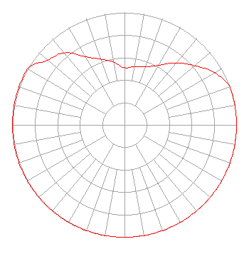 | ||||||||||||||||||
| Azimuth | Ratio | Azimuth | Ratio | Azimuth | Ratio | Azimuth | Ratio | ||||||||||||
| 0 | 0.508 | 10 | 0.527 | 20 | 0.549 | 30 | 0.613 | ||||||||||||
| 40 | 0.721 | 50 | 0.819 | 60 | 0.928 | 70 | 1.000 | ||||||||||||
| 80 | 1.000 | 90 | 1.000 | 100 | 1.000 | 110 | 1.000 | ||||||||||||
| 120 | 1.000 | 130 | 1.000 | 140 | 1.000 | 150 | 1.000 | ||||||||||||
| 160 | 1.000 | 170 | 1.000 | 180 | 1.000 | 190 | 1.000 | ||||||||||||
| 200 | 1.000 | 210 | 1.000 | 220 | 1.000 | 230 | 1.000 | ||||||||||||
| 240 | 1.000 | 250 | 1.000 | 260 | 1.000 | 270 | 1.000 | ||||||||||||
| 280 | 1.000 | 290 | 1.000 | 300 | 1.000 | 310 | 0.898 | ||||||||||||
| 320 | 0.837 | 330 | 0.700 | 340 | 0.623 | 350 | 0.568 | ||||||||||||
Structure Registration Number 1223241 Structure Type: LTOWER Registered To: American Towers LLC Structure Address: 6265 W Sr 42 (cherryvale - 091675) Brazil, IN County Name: Clay County ASR Issued: 01/29/2016 Date Built: 03/13/2000 Site Elevation: 189.3 m (621 ft.) Structure Height: 70.1 m (230 ft.) Height Overall: 71.6 m (235 ft.) Overall Height AMSL: 260.9 m (856 ft.) FAA Determination: 01/27/2016 FAA Study #: 2015-AGL-17596-OE FAA Circular #: 70/7460-1J Paint & Light FAA Chapters: 4, 8, 13 OM&L to remain the same as prior study = A MED-DUAL SYSTEM 39-26-47.7 N 87-13-29.2 W (NAD 83) 39-26-47.6 N 87-13-29.1 W (Converted to NAD 27) |
2175 Highway 75 Suite 6 Blountville, TN 37617 Phone: 423-878-6279 Not-for-Profit | Title: Director And President Date: 11/09/2021 Application Certifier Appalachian Educational Communication Corporation 2175 Highway 75 Suite 6 Blountville, TN 37617 Applicant Appalachian Educational Communication Corporation 2175 Highway 75 Suite 6 Blountville, TN 37617 Applicant John Jason Bennett Fm Expansion Group, Llc 7107 South Yale #444 Tulsa, OK 74136 | |||||||||||||||||