
FCCInfo.com
A Service of Cavell, Mertz & Associates, Inc.
(855) FCC-INFO
|
|
W281CL from 11/06/2013 |
|
|
||||||||||||||||
|
|
W281CL Channel: 281D 104.1 MHz Cherry Hill, New Jersey Service: FX - A translator or application for a translator. Facility ID: 141368 Fac. Service: FX Programming Delivery Method: Unspecified Status: Construction Permit Application Accepted: 01/07/2022 Application Granted: 01/25/2022 File Number: -0000179263 W281CL CP Expires: 01/24/2025 Application Type: Minor Modification FCC Website Links: LMS Facility Details This Application Other W281CL Applications Other W281CL Applications in CDBS Including Superseded Applications Mailing Address Correspondence for W281CL Correspondence related to application -0000179263 Service Contour - Open Street Map or USGS Map (60 dBu) Service Contour - KML / Google Earth (60 dBu) Facility Type: FM STATION Class: D, A Noncommercial educational operating with no more than 10W Site Location: 39-56-03.4 N 74-53-37.9 W (NAD 83) Site Location: 39-56-03.0 N 74-53-39.3 W (Converted to NAD 27) Effective Radiated Power: 0.13 kW Antenna Center HAAT: 0 m Antenna Center AMSL: 89.5 m (294 ft.) Antenna Center HAG: 38 m (125 ft.) Site Elevation: 51.5 m. (169 ft.) Height Overall*: 54.5 m (179 ft.) (* As Filed In This Application, may differ from ASR Data, Below.) Directional Antenna Antenna Make/Model: BEXT LOG R Antenna ID: 115935 Polarization: H
| ||||||||||||||||||
| Antenna Data for Antenna Id: 115935 W281CL FX File: -0000179263 BEXT - LOG R Service: FX | 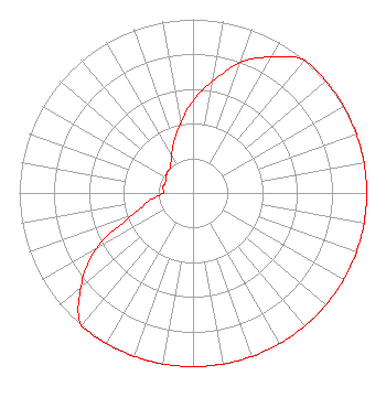 | ||||||||||||||||||
| Azimuth | Ratio | Azimuth | Ratio | Azimuth | Ratio | Azimuth | Ratio | ||||||||||||
| 0 | 0.531 | 10 | 0.654 | 20 | 0.800 | 30 | 0.905 | ||||||||||||
| 40 | 1.000 | 50 | 1.000 | 60 | 1.000 | 70 | 1.000 | ||||||||||||
| 80 | 1.000 | 90 | 1.000 | 100 | 1.000 | 110 | 1.000 | ||||||||||||
| 120 | 1.000 | 130 | 1.000 | 140 | 1.000 | 150 | 1.000 | ||||||||||||
| 160 | 1.000 | 170 | 1.000 | 180 | 1.000 | 190 | 1.000 | ||||||||||||
| 200 | 1.000 | 210 | 1.000 | 220 | 1.000 | 230 | 0.843 | ||||||||||||
| 240 | 0.644 | 250 | 0.369 | 260 | 0.252 | 270 | 0.170 | ||||||||||||
| 280 | 0.178 | 290 | 0.170 | 300 | 0.180 | 310 | 0.191 | ||||||||||||
| 320 | 0.201 | 330 | 0.249 | 340 | 0.320 | 350 | 0.407 | ||||||||||||
Structure Registration Number 1045856 Structure Type: TOWER Registered To: American Towers LLC Structure Address: 443 Mt Laurel Road (000061) Mount Laurel, NJ County Name: Burlington County ASR Issued: 01/15/2013 Date Built: 05/17/2002 Site Elevation: 51.5 m (169 ft.) Structure Height: 48.2 m (158 ft.) Height Overall: 54.5 m (179 ft.) Overall Height AMSL: 106 m (348 ft.) FAA Determination: 10/28/2009 FAA Study #: 2009-AEA-3259-OE FAA Circular #: 70/7460-1K Paint & Light FAA Chapters: 4, 8, 12 PRIOR STUDY 2006-AEA-4249-OE 39-56-03.4 N 74-53-37.9 W (NAD 83) 39-56-03.0 N 74-53-39.3 W (Converted to NAD 27) |
2224 Federal Street Camden, NJ 08107 Phone: 401-340-9332 Limited Liability Company | Title: President Date: 01/07/2022 Application Certifier Ritmo Broadcasting, Llc 2224 Federal Street Camden, NJ 08107 Applicant QUILVIO N PERDOMO, PERDOMO Perdomo Media Group 25 Woodman St. Providence, RI 02907 TECHNICAL CONSULTANT Miguel Amador Ritmo Broadcasting, Llc 2224 Federal Street Camden, NJ 08107 President | |||||||||||||||||