
FCCInfo.com
A Service of Cavell, Mertz & Associates, Inc.
(855) FCC-INFO
|
|
WZBH from 06/28/2007 WZBH from 07/01/1988 WZBH from 09/03/1987 |
|  |
|
|||||||||||||||
|
|
WZBH Channel: 228B 93.5 MHz Millsboro, Delaware Service: FM - A full-service FM station or application. Facility ID: 25003 Fac. Service: FM Status: License 73.215 Station Application Accepted: 12/17/2021 Application Granted: 12/20/2021 File Number: -0000177437 License Expires: 08/01/2022 Application Type: License To Cover FCC Website Links: LMS Facility Details This Application Other WZBH Applications Other WZBH Applications in CDBS Including Superseded Applications Mailing Address Correspondence for WZBH Correspondence related to application -0000177437 Service Contour - Open Street Map or USGS Map (54 dBu) Service Contour - KML / Google Earth (54 dBu) Public Inspection Files History Cards for WZBH Facility Type: FM STATION Class: B, A Zone I or I-A station; with 25kW-50kW ERP and a class contour distance 39km-52km Site Location: 38-31-28.8 N 75-17-52.6 W (NAD 83) Site Location: 38-31-28.4 N 75-17-53.9 W (Converted to NAD 27) Effective Radiated Power: 50 kW Transmitter Output Power: 20.07 kW Antenna Center HAAT: 150 m (492 ft.) Antenna Center AMSL: 160 m (525 ft.) Antenna Center HAG: 148 m (486 ft.) Site Elevation: 12.2 m. (40 ft.) Height Overall*: 158.5 m (520 ft.) (* As Filed In This Application, may differ from ASR Data, Below.) Directional Antenna Antenna Make/Model: Electronics Research Inc. SHP-3AE-DA Antenna ID: 118143 Polarization: | ||||||||||||||||||
| Antenna Data for Antenna Id: 118143 WZBH FM File: -0000177437 Electronics Research Inc. - SHP-3AE-DA Service: FM | 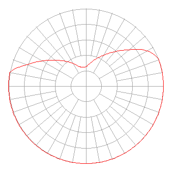 | ||||||||||||||||||
| Azimuth | Ratio | Azimuth | Ratio | Azimuth | Ratio | Azimuth | Ratio | ||||||||||||
| 0 | 0.250 | 10 | 0.300 | 20 | 0.370 | 30 | 0.460 | ||||||||||||
| 40 | 0.580 | 50 | 0.730 | 60 | 0.910 | 70 | 1.000 | ||||||||||||
| 80 | 1.000 | 90 | 1.000 | 100 | 1.000 | 110 | 1.000 | ||||||||||||
| 120 | 1.000 | 130 | 1.000 | 140 | 1.000 | 150 | 1.000 | ||||||||||||
| 160 | 1.000 | 170 | 1.000 | 180 | 1.000 | 190 | 1.000 | ||||||||||||
| 200 | 1.000 | 210 | 1.000 | 220 | 1.000 | 230 | 1.000 | ||||||||||||
| 240 | 1.000 | 250 | 1.000 | 260 | 1.000 | 270 | 1.000 | ||||||||||||
| 280 | 1.000 | 290 | 0.810 | 300 | 0.650 | 310 | 0.520 | ||||||||||||
| 320 | 0.420 | 330 | 0.340 | 340 | 0.270 | 350 | 0.250 | ||||||||||||
Structure Registration Number 1034804 Structure Type: GTOWER Registered To: Clearview Tower Company II, LLC Structure Address: Rt 26 & Rt 82 Dagsboro, DE County Name: Sussex County ASR Issued: 12/30/2019 Date Built: 05/15/2015 Site Elevation: 12.2 m (40 ft.) Structure Height: 156.5 m (513 ft.) Height Overall: 158.5 m (520 ft.) Overall Height AMSL: 170.7 m (560 ft.) FAA Determination: 05/10/2017 FAA Study #: 2017-AEA-4741-OE FAA Circular #: 70/7460-1L Paint & Light FAA Chapters: 3, 4, 5, 12 38-31-28.8 N 75-17-52.6 W (NAD 83) 38-31-28.4 N 75-17-53.9 W (Converted to NAD 27) |
1729 North Salisbury Blvd. Salisbury, MD 21801 Phone: 443-880-9090 Corporation | Title: President And General Manager Date: 12/17/2021 Application Certifier Wboc, Inc. 1729 North Salisbury Blvd. Salisbury, MD 21801 Applicant Josh Lynch Wboc Inc. 1729 North Salisbury Blvd. Salisbury, MD 21801 Chief Engineer Justin W Asher Asher Broadcast Consulting, Llc 579 Babcock Road Bronson, MI 49028 Technical Consultant Jason Rademacher Cooley Llp 1299 Pennsylvania Ave., Nw Suite 700 Washington, DC 20004 Legal Representative | |||||||||||||||||
|
| ||||||||||||||||||