
FCCInfo.com
A Service of Cavell, Mertz & Associates, Inc.
(855) FCC-INFO
|
|
|
|
|
||||||||||||||||
|
|
WGMH Channel: 215B1 90.9 MHz Portsmouth, Ohio Service: FM - A full-service FM station or application. Facility ID: 768679 Fac. Service: FM Status: Construction Permit Application Accepted: 02/01/2022 Application Granted: 03/08/2022 File Number: -0000167396 WGMH CP Expires: 03/08/2025 Application Type: Non-Commercial Educational Amendment FCC Website Links: LMS Facility Details This Application Other WGMH Applications Other WGMH Applications in CDBS Including Superseded Applications Mailing Address Correspondence for WGMH Correspondence related to application -0000167396 Service Contour - Open Street Map or USGS Map (60 dBu) Service Contour - KML / Google Earth (60 dBu) Public Inspection Files Facility Type: NON-COMMERCIAL EDUC. FM Class: B1, A Zone I or I-A station; with 6kW-25kW ERP and a class contour distance 28km-39km Site Location: 38-51-18.5 N 82-48-43.9 W (NAD 83) Site Location: 38-51-18.2 N 82-48-44.3 W (Converted to NAD 27) Effective Radiated Power: 7.5 kW Antenna Center HAAT: 122 m (400 ft.) Antenna Center AMSL: 347 m (1138 ft.) Antenna Center HAG: 77 m (253 ft.) Site Elevation: 270.1 m. (886 ft.) Height Overall*: 77.7 m (255 ft.) (* As Filed In This Application, may differ from ASR Data, Below.) Directional Antenna Antenna Make/Model: None Antenna ID: 69-2019-08-06 Polarization: | ||||||||||||||||||
| Antenna Data for Antenna Id: 69-2019-08-06 WGMH FM File: -0000167396 None - Service: FM | 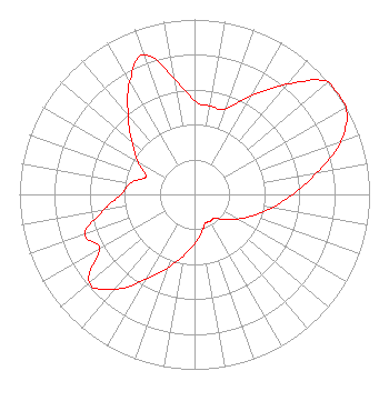 | ||||||||||||||||||
| Azimuth | Ratio | Azimuth | Ratio | Azimuth | Ratio | Azimuth | Ratio | ||||||||||||
| 0 | 0.535 | 10 | 0.512 | 20 | 0.519 | 30 | 0.653 | ||||||||||||
| 40 | 0.822 | 50 | 1.000 | 60 | 1.000 | 70 | 0.891 | ||||||||||||
| 80 | 0.708 | 90 | 0.562 | 100 | 0.447 | 110 | 0.355 | ||||||||||||
| 120 | 0.282 | 130 | 0.224 | 140 | 0.178 | 150 | 0.178 | ||||||||||||
| 160 | 0.178 | 170 | 0.224 | 180 | 0.282 | 190 | 0.355 | ||||||||||||
| 200 | 0.447 | 210 | 0.562 | 220 | 0.708 | 230 | 0.786 | ||||||||||||
| 240 | 0.625 | 250 | 0.665 | 260 | 0.529 | 270 | 0.420 | ||||||||||||
| 280 | 0.372 | 290 | 0.295 | 300 | 0.372 | 310 | 0.468 | ||||||||||||
| 320 | 0.589 | 330 | 0.741 | 340 | 0.849 | 350 | 0.674 | ||||||||||||
Structure Registration Number 1014270 Structure Type: TOWER Registered To: Alltel Corporation Structure Address: 335 S To Barnet School R On Glades Ran Rd (minford - 140000088) Minford, OH County Name: Scioto County ASR Issued: 02/05/2019 Date Built: 05/17/2006 Site Elevation: 270.1 m (886 ft.) Structure Height: 73.2 m (240 ft.) Height Overall: 77.7 m (255 ft.) Overall Height AMSL: 347.8 m (1141 ft.) FAA Determination: 12/15/2004 FAA Study #: 2004-AGL-6972-OE FAA Circular #: 70/7460-1H Paint & Light FAA Chapters: 4, 8, 13 PRIOR STUDY 1994-AGL-2060-OE 38-51-18.5 N 82-48-43.9 W (NAD 83) 38-51-18.2 N 82-48-44.3 W (Converted to NAD 27) |
1205 Whitefield Circle Xenia, OH 45385 Phone: 937-424-1640 Not-for-Profit | Title: Member Date: 02/01/2022 Application Certifier New Beginnings Movement Inc 900 W Powers St Muncie, IN 47305 Applicant Robert J Robbins Radio Data Services 20808 Sw 83 Ave Cutler Bay, FL 33189 Technical Consultant MARTIN Lynn HENSLEY New Beginnings Movement Inc 900 W Powers St Muncie, IN 47305 Member | |||||||||||||||||