
FCCInfo.com
A Service of Cavell, Mertz & Associates, Inc.
(855) FCC-INFO
|
|
|
|
|
||||||||||||||||
|
|
W224CO Channel: 224D 92.7 MHz Greensboro, North Carolina Service: FX - A translator or application for a translator. Facility ID: 148537 Fac. Service: FX Programming Delivery Method: Unspecified Status: License Application Accepted: 02/15/2022 Application Granted: 03/31/2022 File Number: -0000184889 License Expires: 12/01/2027 Application Type: License To Cover FCC Website Links: LMS Facility Details This Application Other W224CO Applications Other W224CO Applications in CDBS Including Superseded Applications Mailing Address Correspondence for W224CO Correspondence related to application -0000184889 Service Contour - Open Street Map or USGS Map (60 dBu) Service Contour - KML / Google Earth (60 dBu) Facility Type: FM STATION Class: D, A Noncommercial educational operating with no more than 10W Site Location: 36-03-42.0 N 79-47-34.0 W (NAD 83) Site Location: 36-03-41.5 N 79-47-34.9 W (Converted to NAD 27) Effective Radiated Power: 0 kW Horiz. ; 0.25 kW Vert. Transmitter Output Power: 0.085 kW Antenna Center HAAT: 0 m Antenna Center AMSL: 0 m Horiz.; 321.6 m Vert. Antenna Center HAG: 0 m Horiz.; 71.6 m Vert. Site Elevation: 250 m. (820 ft.) Height Overall*: 81.4 m (267 ft.) (* As Filed In This Application, may differ from ASR Data, Below.) Directional Antenna Antenna Make/Model: Jampro J3YF/1 Antenna ID: 120665 Polarization: H
| ||||||||||||||||||
| Antenna Data for Antenna Id: 120665 W224CO FX File: -0000184889 Jampro - J3YF/1 Service: FX | 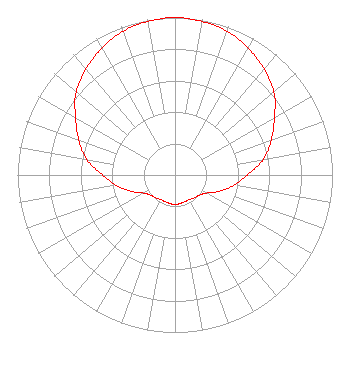 | ||||||||||||||||||
| Azimuth | Ratio | Azimuth | Ratio | Azimuth | Ratio | Azimuth | Ratio | ||||||||||||
| 0 | 1.000 | 10 | 0.990 | 20 | 0.970 | 30 | 0.930 | ||||||||||||
| 40 | 0.880 | 50 | 0.820 | 60 | 0.730 | 70 | 0.650 | ||||||||||||
| 80 | 0.570 | 90 | 0.460 | 100 | 0.380 | 110 | 0.300 | ||||||||||||
| 120 | 0.230 | 130 | 0.200 | 140 | 0.190 | 150 | 0.180 | ||||||||||||
| 160 | 0.180 | 170 | 0.185 | 180 | 0.185 | 190 | 0.185 | ||||||||||||
| 200 | 0.180 | 210 | 0.180 | 220 | 0.190 | 230 | 0.200 | ||||||||||||
| 240 | 0.230 | 250 | 0.300 | 260 | 0.380 | 270 | 0.460 | ||||||||||||
| 280 | 0.570 | 290 | 0.650 | 300 | 0.730 | 310 | 0.820 | ||||||||||||
| 320 | 0.880 | 330 | 0.930 | 340 | 0.970 | 350 | 0.990 | ||||||||||||
Structure Registration Number 1235239 Structure Type: TOWER Registered To: Truth Broadcasting Corporation Structure Address: South Eugene Street Greensboro, NC County Name: Guilford County ASR Issued: 05/16/2023 Date Built: 05/29/2003 Site Elevation: 250 m (820 ft.) Structure Height: 81.4 m (267 ft.) Height Overall: 81.4 m (267 ft.) Overall Height AMSL: 331.4 m (1087 ft.) FAA Determination: 07/29/2002 FAA Study #: 02-ASO-3885-OE FAA Circular #: 70/7460-1K Paint & Light FAA Chapters: 4, 8, 12 SUPPLEMENTAL NOTICE STATES STRUCTURE REACHED GREATEST HEIGHT ON 05/29/2003 36-03-42.0 N 79-47-34.0 W (NAD 83) 36-03-41.5 N 79-47-34.9 W (Converted to NAD 27) |
5700 West Oaks Blvd Rocklin, CA 95765 Phone: 916-251-1600 Not-for-Profit | Title: Ceo Date: 02/15/2022 Application Certifier EDUCATIONAL MEDIA FOUNDATION Educational Media Foundation 5700 West Oaks Blvd Rocklin, CA 95765 Applicant James L Travis Educational Media Foundation 5700 West Oaks Blvd Rocklin, CA 95765 FCC COMPLIANCE ENGINEER MARY N O'CONNOR Wilkinson Barker Knauer, Llp 1800 M Street, N.w. Suite 800n Washington, DC 20036 | |||||||||||||||||