
FCCInfo.com
A Service of Cavell, Mertz & Associates, Inc.
(855) FCC-INFO
|
|
WAWE-FM1 from 06/22/2018 |
|
|
||||||||||||||||
|
|
WAWE-FM1 Channel: 232D 94.3 MHz Elmwood Park, Illinois Service: FB - A booster station or application for a booster. Facility ID: 203413 Fac. Service: FB Programming Delivery Method: Unspecified Status: License Application Accepted: 02/22/2022 Application Granted: 03/07/2022 File Number: -0000185178 License Expires: 12/01/2028 Application Type: License To Cover FCC Website Links: LMS Facility Details This Application Other WAWE-FM1 Applications Other WAWE-FM1 Applications in CDBS Including Superseded Applications Mailing Address Correspondence for WAWE-FM1 Correspondence related to application -0000185178 Service Contour - Open Street Map or USGS Map (60 dBu) Service Contour - KML / Google Earth (60 dBu) Facility Type: NON-COMMERCIAL EDUC. FM Class: D, A Noncommercial educational operating with no more than 10W Site Location: 41-55-36.0 N 87-48-24.0 W (NAD 83) Site Location: 41-55-35.9 N 87-48-23.8 W (Converted to NAD 27) Effective Radiated Power: 0.9 kW Antenna Center HAAT: 0 m Antenna Center AMSL: 246.1 m (807 ft.) Antenna Center HAG: 48 m (157 ft.) Site Elevation: 198.1 m. (650 ft.) Height Overall*: 78.9 m (259 ft.) (* As Filed In This Application, may differ from ASR Data, Below.) Directional Antenna Antenna Make/Model: None Antenna ID: 134689 Polarization: H
| ||||||||||||||||||
| Antenna Data for Antenna Id: 134689 WAWE-FM1 FB File: -0000185178 None - Service: FB | 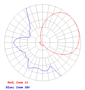 | ||||||||||||||||||
| Azimuth | Ratio | Azimuth | Ratio | Azimuth | Ratio | Azimuth | Ratio | ||||||||||||
| 0 | 0.429 | 10 | 0.616 | 20 | 0.780 | 30 | 0.905 | ||||||||||||
| 40 | 0.975 | 50 | 0.995 | 60 | 1.000 | 70 | 0.995 | ||||||||||||
| 80 | 0.975 | 90 | 0.942 | 100 | 0.895 | 110 | 0.797 | ||||||||||||
| 120 | 0.628 | 130 | 0.424 | 140 | 0.241 | 150 | 0.112 | ||||||||||||
| 160 | 0.067 | 170 | 0.074 | 180 | 0.073 | 190 | 0.068 | ||||||||||||
| 200 | 0.070 | 210 | 0.075 | 220 | 0.057 | 230 | 0.057 | ||||||||||||
| 240 | 0.053 | 250 | 0.061 | 260 | 0.068 | 270 | 0.075 | ||||||||||||
| 280 | 0.065 | 290 | 0.040 | 300 | 0.037 | 310 | 0.046 | ||||||||||||
| 320 | 0.050 | 330 | 0.075 | 340 | 0.141 | 350 | 0.258 | ||||||||||||
Structure Registration Number 1029448 Structure Type: TOWER Registered To: MARTIC, DRAGUTIN Structure Address: 2526 N Harlem Elmwood Park, IL County Name: Cook County ASR Issued: 11/03/1997 Date Built: 01/01/1947 Site Elevation: 198.1 m (650 ft.) Structure Height: 78.9 m (259 ft.) Height Overall: 78.9 m (259 ft.) Overall Height AMSL: 277.1 m (909 ft.) Paint & Light FAA Chapters: 1, 3, 11, 21 41-55-36.0 N 87-48-24.0 W (NAD 83) 41-55-35.9 N 87-48-23.8 W (Converted to NAD 27) |
5700 West Oaks Blvd. Rocklin, CA 95765 Phone: 916-251-1600 Not-for-Profit | Title: Ceo Date: 02/22/2022 Application Certifier EDUCATIONAL MEDIA FOUNDATION Educational Media Foundation 5700 West Oaks Blvd. Rocklin, CA 95765 Applicant Mary N O'Connor, ESQ Wilkinson Barker Knauer, Llp 1800 M. Street, N.w. Suite 800n Washington, DC 20036 Legal Representative James L Travis Educational Media Foundation 5700 West Oaks Blvd. Rocklin, CA 95765 FCC COMPLIANCE ENGINEER | |||||||||||||||||