
FCCInfo.com
A Service of Cavell, Mertz & Associates, Inc.
(855) FCC-INFO
|
|
|
|  |
|
|||||||||||||||
|
|
WYFL Channel: 223C0 92.5 MHz Henderson, North Carolina Service: FM - A full-service FM station or application. Facility ID: 5100 Fac. Service: FM Status: License Application Accepted: 05/05/2022 Application Granted: 05/24/2022 File Number: -0000190115 License Expires: 12/01/2027 Application Type: License To Cover FCC Website Links: LMS Facility Details This Application Other WYFL Applications Other WYFL Applications in CDBS Including Superseded Applications Mailing Address Correspondence for WYFL Correspondence related to application -0000190115 Service Contour - Open Street Map or USGS Map (60 dBu) Service Contour - KML / Google Earth (60 dBu) Public Inspection Files History Cards for WYFL Facility Type: NON-COMMERCIAL EDUC. FM Class: C0, C0 Site Location: 36-13-30.4 N 78-12-08.8 W (NAD 83) Site Location: 36-13-29.9 N 78-12-09.8 W (Converted to NAD 27) Effective Radiated Power: 100 kW Transmitter Output Power: 17.65 kW Antenna Center HAAT: 304 m (997 ft.) Antenna Center AMSL: 407 m (1335 ft.) Antenna Center HAG: 285 m (935 ft.) Site Elevation: 122.2 m. (401 ft.) Height Overall*: 304.2 m (998 ft.) (* As Filed In This Application, may differ from ASR Data, Below.) Directional Antenna Antenna Make/Model: Systems With Reliability FM10R/8-DA Antenna ID: 118738 Polarization:
| ||||||||||||||||||
| Antenna Data for Antenna Id: 118738 WYFL FM File: -0000190115 Systems With Reliability - FM10R/8-DA Service: FM | 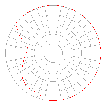 | ||||||||||||||||||
| Azimuth | Ratio | Azimuth | Ratio | Azimuth | Ratio | Azimuth | Ratio | ||||||||||||
| 0 | 1.000 | 10 | 1.000 | 20 | 1.000 | 30 | 1.000 | ||||||||||||
| 40 | 1.000 | 50 | 1.000 | 60 | 1.000 | 70 | 1.000 | ||||||||||||
| 80 | 1.000 | 90 | 1.000 | 100 | 1.000 | 110 | 1.000 | ||||||||||||
| 120 | 1.000 | 130 | 1.000 | 140 | 1.000 | 150 | 1.000 | ||||||||||||
| 160 | 1.000 | 170 | 1.000 | 180 | 1.000 | 190 | 1.000 | ||||||||||||
| 200 | 0.900 | 210 | 0.900 | 220 | 0.880 | 230 | 0.830 | ||||||||||||
| 240 | 0.750 | 250 | 0.670 | 260 | 0.615 | 270 | 0.560 | ||||||||||||
| 280 | 0.530 | 290 | 0.660 | 300 | 0.830 | 310 | 1.000 | ||||||||||||
| 320 | 1.000 | 330 | 1.000 | 340 | 1.000 | 350 | 1.000 | ||||||||||||
Structure Registration Number 1002317 Structure Type: GTOWER Registered To: Bible Broadcasting Network, Inc. Structure Address: On State Route 1407; 2.1 Kilometers East Of Alert, Nc. Alert, NC County Name: Franklin County ASR Issued: 02/18/2022 Date Built: 01/01/1984 Site Elevation: 122.2 m (401 ft.) Structure Height: 303.1 m (994 ft.) Height Overall: 304.2 m (998 ft.) Overall Height AMSL: 426.4 m (1399 ft.) FAA Determination: 02/17/2022 FAA Study #: 2021-ASO-38313-OE FAA Circular #: 70/7460-1L Paint & Light FAA Chapters: 3, 4, 5, 12 PRIOR STUDY 2017-ASO-11387-OE 36-13-30.4 N 78-12-08.8 W (NAD 83) 36-13-29.9 N 78-12-09.8 W (Converted to NAD 27) |
11530 Carmel Commons Boulevard Charlotte, NC 28226 Phone: 704-523-5555 Not-for-Profit | Title: Secretary-treasurer Date: 05/05/2022 Application Certifier BIBLE BROADCASTING NETWORK, INC. Bible Broadcasting Network, Inc. 11530 Carmel Commons Boulevard Charlotte, NC 28226 Applicant Justin Asher Asher Broadcast Consulting, Llc 579 Babcock Road Bronson, MI 49028-9347 Technical Consultant Gary S. Smithwick, Esq Smithwick & Belendiuk, P.c. 5028 Wisconsin Avenue, N.w. Suite 301 Washington, DC 20016 Legal Counsel | |||||||||||||||||