
FCCInfo.com
A Service of Cavell, Mertz & Associates, Inc.
(855) FCC-INFO
|
|
WLAI from 02/26/2010 WLAI from 03/01/2006 WLAI from 07/31/1995 |
|
|
||||||||||||||||
|
|
WLAI Channel: 296A 107.1 MHz Wilmore, Kentucky Service: FM - A full-service FM station or application. Facility ID: 52309 Fac. Service: FM Analog & Digital Status: License 73.215 Station Application Accepted: 03/11/2022 Application Granted: 06/24/2022 File Number: -0000186535 License Expires: 08/01/2028 Application Type: Minor Modification FCC Website Links: LMS Facility Details This Application Other WLAI Applications Other WLAI Applications in CDBS Including Superseded Applications Mailing Address Correspondence for WLAI Correspondence related to application -0000186535 Service Contour - Open Street Map or USGS Map (60 dBu) Service Contour - KML / Google Earth (60 dBu) Public Inspection Files History Cards for WLAI Facility Type: NON-COMMERCIAL EDUC. FM Class: A, A Zone I; I-A; or II station; with 0.1kW-6kW ERP and a class contour distance <=28km Site Location: 37-57-37.0 N 84-32-42.0 W (NAD 83) Site Location: 37-57-36.7 N 84-32-42.2 W (Converted to NAD 27) Effective Radiated Power: 3.6 kW Transmitter Output Power: 5.386 kW Antenna Center HAAT: 128 m (420 ft.) Antenna Center AMSL: 412 m (1352 ft.) Antenna Center HAG: 98 m (322 ft.) Calculated Site Elevation: 314 m. (1030 ft.) Height Overall*: 101 m (331 ft.) (* As Filed In This Application, may differ from ASR Data, Below.) Directional Antenna Antenna Make/Model: Electronics Research Inc. LP-2E-DA-HW Antenna ID: 95962 Polarization:
| ||||||||||||||||||
| Antenna Data for Antenna Id: 95962 WLAI FM File: -0000186535 Electronics Research Inc. - LP-2E-DA-HW Service: FM | 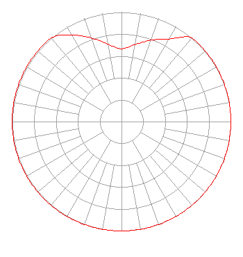 | ||||||||||||||||||
| Azimuth | Ratio | Azimuth | Ratio | Azimuth | Ratio | Azimuth | Ratio | ||||||||||||
| 0 | 0.665 | 10 | 0.714 | 20 | 0.792 | 30 | 0.871 | ||||||||||||
| 40 | 1.000 | 50 | 1.000 | 60 | 1.000 | 70 | 1.000 | ||||||||||||
| 80 | 1.000 | 90 | 1.000 | 100 | 1.000 | 110 | 1.000 | ||||||||||||
| 120 | 1.000 | 130 | 1.000 | 140 | 1.000 | 150 | 1.000 | ||||||||||||
| 160 | 1.000 | 170 | 1.000 | 180 | 1.000 | 190 | 1.000 | ||||||||||||
| 200 | 1.000 | 210 | 1.000 | 220 | 1.000 | 230 | 1.000 | ||||||||||||
| 240 | 1.000 | 250 | 1.000 | 260 | 1.000 | 270 | 1.000 | ||||||||||||
| 280 | 1.000 | 290 | 1.000 | 300 | 1.000 | 310 | 1.000 | ||||||||||||
| 320 | 1.000 | 330 | 0.915 | 340 | 0.814 | 350 | 0.719 | ||||||||||||
Structure Registration Number 1217449 Structure Type: TOWER Registered To: Clearview Tower Company III, LLC Structure Address: On Brannon Rd. 0.2 Miles West Of Us 27 Lexington, KY County Name: Jessamine County ASR Issued: 09/19/2023 Date Built: 02/17/2010 Site Elevation: 314 m (1030 ft.) Structure Height: 100.6 m (330 ft.) Height Overall: 100.6 m (330 ft.) Overall Height AMSL: 414.6 m (1360 ft.) FAA Determination: 09/01/2009 FAA Study #: 2009-ASO-4075-OE Paint & Light FAA Chapters: A1, H, 3, 11, 21, 23 PRIOR STUDY 2008-ASO-2221-OE 37-57-37.0 N 84-32-42.0 W (NAD 83) 37-57-36.7 N 84-32-42.2 W (Converted to NAD 27) |
5700 West Oaks Boulevard Rocklin, CA 95765 Phone: 916-251-1600 Not-for-Profit | Title: Ceo Date: 03/11/2022 Application Certifier EDUCATIONAL MEDIA FOUNDATION Educational Media Foundation 5700 West Oaks Boulevard Rocklin, CA 95765 Applicant MARY O'CONNOR Wilkinson Barker Knauer, Llp 1800 M. Street, N.w., Suite 800n Washington, DC 20036 JAMES L TRAVIS Educational Media Foundation 5700 West Oaks Blvd Rocklin, CA 95765 FCC COMPLIANCE ENGINEER | |||||||||||||||||