
FCCInfo.com
A Service of Cavell, Mertz & Associates, Inc.
(855) FCC-INFO
|
|
|
|
|
||||||||||||||||
|
|
Channel: 218A 91.5 MHz Starke, Florida Service: FM - A full-service FM station or application. Facility ID: 768068 Fac. Service: FM Status: Construction Permit Application Accepted: 04/06/2022 Application Granted: 02/24/2023 File Number: -0000167485 CP Expires: 02/24/2026 Application Type: Non-Commercial Educational Amendment FCC Website Links: LMS Facility Details This Application Other Applications Other Applications in CDBS Including Superseded Applications Mailing Address Correspondence for Correspondence related to application -0000167485 Service Contour - Open Street Map or USGS Map (60 dBu) Service Contour - KML / Google Earth (60 dBu) Facility Type: NON-COMMERCIAL EDUC. FM Class: A, A Zone I; I-A; or II station; with 0.1kW-6kW ERP and a class contour distance <=28km Site Location: 29-50-03.0 N 81-58-40.5 W (NAD 83) Site Location: 29-50-02.1 N 81-58-41.1 W (Converted to NAD 27) Effective Radiated Power: 3.3 kW Antenna Center HAAT: 103 m (338 ft.) Antenna Center AMSL: 152 m (499 ft.) Antenna Center HAG: 97 m (318 ft.) Site Elevation: 54.6 m. (179 ft.) Height Overall*: 101.8 m (334 ft.) (* As Filed In This Application, may differ from ASR Data, Below.) Directional Antenna Antenna Make/Model: None Antenna ID: 69-2019-08-06 Polarization: | ||||||||||||||||||
| Antenna Data for Antenna Id: 69-2019-08-06 FM File: -0000167485 None - Service: FM | 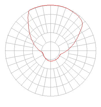 | ||||||||||||||||||
| Azimuth | Ratio | Azimuth | Ratio | Azimuth | Ratio | Azimuth | Ratio | ||||||||||||
| 0 | 1.000 | 10 | 1.000 | 20 | 1.000 | 30 | 0.981 | ||||||||||||
| 40 | 0.970 | 50 | 0.914 | 60 | 0.726 | 70 | 0.577 | ||||||||||||
| 80 | 0.458 | 90 | 0.364 | 100 | 0.289 | 110 | 0.234 | ||||||||||||
| 120 | 0.231 | 130 | 0.231 | 140 | 0.231 | 150 | 0.231 | ||||||||||||
| 160 | 0.231 | 170 | 0.231 | 180 | 0.231 | 190 | 0.226 | ||||||||||||
| 200 | 0.216 | 210 | 0.206 | 220 | 0.197 | 230 | 0.188 | ||||||||||||
| 240 | 0.178 | 250 | 0.178 | 260 | 0.190 | 270 | 0.240 | ||||||||||||
| 280 | 0.302 | 290 | 0.380 | 300 | 0.479 | 310 | 0.603 | ||||||||||||
| 320 | 0.759 | 330 | 0.956 | 332 | 1.000 | 340 | 1.000 | ||||||||||||
| 350 | 1.000 | ||||||||||||||||||
Structure Registration Number 1036079 Structure Type: LTOWER Registered To: American Towers LLC Structure Address: 6523-1 S.r. 21 (#88433) Goldhead, FL County Name: Clay County ASR Issued: 03/07/2018 Date Built: 10/18/1960 Site Elevation: 54.6 m (179 ft.) Structure Height: 97.5 m (320 ft.) Height Overall: 101.8 m (334 ft.) Overall Height AMSL: 156.4 m (513 ft.) FAA Determination: 03/06/2018 FAA Study #: 2018-ASO-869-OE FAA Circular #: 70/7460-1K Paint & Light FAA Chapters: 4, 8, 12 OM&L to remain the same as prior study = A MED-DUAL SYSTEM 29-50-03.0 N 81-58-40.5 W (NAD 83) 29-50-02.1 N 81-58-41.1 W (Converted to NAD 27) |
7886 Dry Creek Rd. Summerville, GA 30747 Phone: 678-826-7554 Not-for-Profit | Title: President Date: 04/06/2022 Application Certifier Inverse Focus Ministry, Inc. 7886 Dry Creek Rd. Summerville, GA 30747 Applicant Luke Rogers Luke Rogers Consulting 1435 Woodland Ridge Rd Odenville, AL 35120 | |||||||||||||||||