
FCCInfo.com
A Service of Cavell, Mertz & Associates, Inc.
(855) FCC-INFO
|
|
|
|
|
||||||||||||||||
|
|
K235CD Channel: 235D 94.9 MHz Omaha, Nebraska Service: FX - A translator or application for a translator. Facility ID: 138619 Fac. Service: FX Programming Delivery Method: Unspecified Status: License Application Accepted: 07/13/2022 Application Granted: 07/20/2022 File Number: -0000194942 License Expires: 06/01/2029 Application Type: License To Cover FCC Website Links: LMS Facility Details This Application Other K235CD Applications Other K235CD Applications in CDBS Including Superseded Applications Mailing Address Correspondence for K235CD Correspondence related to application -0000194942 Service Contour - Open Street Map or USGS Map (60 dBu) Service Contour - KML / Google Earth (60 dBu) Facility Type: FM STATION Class: D, A Noncommercial educational operating with no more than 10W Site Location: 41-15-25.4 N 95-57-03.8 W (NAD 83) Site Location: 41-15-25.4 N 95-57-02.7 W (Converted to NAD 27) Effective Radiated Power: 0 kW Horiz. ; 0.25 kW Vert. Transmitter Output Power: 0.065 kW Antenna Center HAAT: 0 m Antenna Center AMSL: 0 m Horiz.; 437.9 m Vert. Antenna Center HAG: 0 m Horiz.; 78.5 m Vert. Site Elevation: 359.4 m. (1179 ft.) Height Overall*: 120.4 m (395 ft.) (* As Filed In This Application, may differ from ASR Data, Below.) Directional Antenna Antenna Make/Model: Scala FMVMP-4 Antenna ID: 119627 Polarization: H
| ||||||||||||||||||
| Antenna Data for Antenna Id: 119627 K235CD FX File: -0000194942 Scala - FMVMP-4 Service: FX | 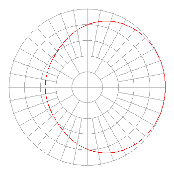 | ||||||||||||||||||
| Azimuth | Ratio | Azimuth | Ratio | Azimuth | Ratio | Azimuth | Ratio | ||||||||||||
| 0 | 0.792 | 10 | 0.845 | 20 | 0.892 | 30 | 0.929 | ||||||||||||
| 40 | 0.956 | 50 | 0.975 | 60 | 0.987 | 70 | 0.995 | ||||||||||||
| 80 | 0.999 | 90 | 1.000 | 100 | 0.999 | 110 | 0.995 | ||||||||||||
| 120 | 0.987 | 130 | 0.975 | 140 | 0.956 | 150 | 0.929 | ||||||||||||
| 160 | 0.892 | 170 | 0.845 | 180 | 0.792 | 190 | 0.734 | ||||||||||||
| 200 | 0.679 | 210 | 0.630 | 220 | 0.592 | 230 | 0.566 | ||||||||||||
| 240 | 0.549 | 250 | 0.539 | 260 | 0.535 | 270 | 0.534 | ||||||||||||
| 280 | 0.535 | 290 | 0.539 | 300 | 0.549 | 310 | 0.566 | ||||||||||||
| 320 | 0.592 | 330 | 0.630 | 340 | 0.679 | 350 | 0.734 | ||||||||||||
Structure Registration Number 1025132 Structure Type: TOWER Registered To: Scripps Broadcasting Holdings LLC Structure Address: 2614 Harney Street Omaha, NE County Name: Douglas County ASR Issued: 02/11/2016 Date Built: 10/18/2011 Site Elevation: 359.4 m (1179 ft.) Structure Height: 120.4 m (395 ft.) Height Overall: 120.4 m (395 ft.) Overall Height AMSL: 479.8 m (1574 ft.) FAA Determination: 07/05/2011 FAA Study #: 2011-ACE-1506-OE FAA Circular #: 70/7460-1K Paint & Light FAA Chapters: 4, 8, 12 Removed final date from determination. Scenario 3./jjs/case#635066 41-15-25.4 N 95-57-03.8 W (NAD 83) 41-15-25.4 N 95-57-02.7 W (Converted to NAD 27) |
7136 S. Yale Avenue Suite 501 Tulsa, OK 74136 Phone: 918-664-4581 Limited Liability Company | Title: Vp, Technical Regulatory Affairs Date: 07/13/2022 Application Certifier IHM LICENSES, LLC Ihm Licenses, Llc 7136 S. Yale Avenue Suite 501 Tulsa, OK 74136 Applicant Troy G Langham Ihm Licenses, Llc 7136 S. Yale Avenue Suite 501 Tulsa, OK 74136 VP, Technical Regulatory Affairs | |||||||||||||||||