
FCCInfo.com
A Service of Cavell, Mertz & Associates, Inc.
(855) FCC-INFO
|
|
W240CA from 08/21/2007 W240CA from 08/30/2004 |
|
|
||||||||||||||||
|
|
W240CA Channel: 240D 95.9 MHz Brentwood, Tennessee Service: FX - A translator or application for a translator. Facility ID: 140709 Fac. Service: FX Programming Delivery Method: Unspecified Status: Construction Permit Application Accepted: 11/17/2022 Application Granted: 12/02/2022 File Number: -0000203705 W240CA CP Expires: 12/02/2025 Application Type: Minor Modification FCC Website Links: LMS Facility Details This Application Other W240CA Applications Other W240CA Applications in CDBS Including Superseded Applications Mailing Address Correspondence for W240CA Correspondence related to application -0000203705 Service Contour - Open Street Map or USGS Map (60 dBu) Service Contour - KML / Google Earth (60 dBu) Facility Type: FM STATION Class: D, A Noncommercial educational operating with no more than 10W Site Location: 36-16-04.9 N 86-47-44.7 W (NAD 83) Site Location: 36-16-04.7 N 86-47-44.7 W (Converted to NAD 27) Effective Radiated Power: 0.25 kW Antenna Center HAAT: 0 m Antenna Center AMSL: 475.7 m (1561 ft.) Antenna Center HAG: 244 m (801 ft.) Site Elevation: 231.7 m. (760 ft.) Height Overall*: 392.9 m (1289 ft.) (* As Filed In This Application, may differ from ASR Data, Below.) Directional Antenna Antenna Make/Model: NICOM BKY-3P-2 Antenna ID: 0 Polarization: H
| ||||||||||||||||||
| Antenna Data for Antenna Id: 0 W240CA FX File: -0000203705 NICOM - BKY-3P-2 Service: FX | 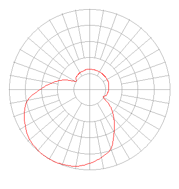 | ||||||||||||||||||
| Azimuth | Ratio | Azimuth | Ratio | Azimuth | Ratio | Azimuth | Ratio | ||||||||||||
| 0 | 0.250 | 10 | 0.250 | 20 | 0.250 | 30 | 0.250 | ||||||||||||
| 40 | 0.250 | 50 | 0.250 | 60 | 0.250 | 70 | 0.250 | ||||||||||||
| 80 | 0.240 | 90 | 0.240 | 100 | 0.230 | 110 | 0.220 | ||||||||||||
| 120 | 0.200 | 130 | 0.340 | 140 | 0.470 | 150 | 0.610 | ||||||||||||
| 160 | 0.780 | 170 | 0.860 | 180 | 0.920 | 190 | 0.970 | ||||||||||||
| 200 | 0.990 | 210 | 1.000 | 220 | 0.990 | 230 | 0.970 | ||||||||||||
| 240 | 0.920 | 250 | 0.860 | 260 | 0.780 | 270 | 0.610 | ||||||||||||
| 280 | 0.470 | 290 | 0.340 | 300 | 0.200 | 310 | 0.220 | ||||||||||||
| 320 | 0.230 | 330 | 0.240 | 340 | 0.240 | 350 | 0.250 | ||||||||||||
Structure Registration Number 1233975 Structure Type: GTOWER Registered To: American Towers LLC Structure Address: Nashville, Tn Nashville, TN County Name: Davidson County ASR Issued: 05/16/2017 Date Built: 03/15/2002 Site Elevation: 231.7 m (760 ft.) Structure Height: 352.9 m (1158 ft.) Height Overall: 392.9 m (1289 ft.) Overall Height AMSL: 624.6 m (2049 ft.) FAA Study #: 02-ASO-2205-OE FAA Circular #: Paint & Light FAA Chapters: A1, B, E, H, 3, 8, 17, 21, 23 FAA Study 2002-ASO-2205-OE requires Dual-red and high intensity white. 36-16-04.9 N 86-47-44.7 W (NAD 83) 36-16-04.7 N 86-47-44.7 W (Converted to NAD 27) |
810 Dominican Drive Nashville, TN 37228 Phone: 615-844-1039 Not-for-Profit | Title: Ceo Date: 11/17/2022 Application Certifier SOUTHERN WABASH COMMUNICATIONS OF MIDDLE TENNESSEE, INC. Southern Wabash Communications Of Middle Tennessee, Inc. 810 Dominican Drive Nashville, TN 37228 Applicant JIM TURVAVILLE Turbo Tech Services 360 Patton Street - Po Box 144 Mobeetie, TX 79061 CONSULTING ENGINEER | |||||||||||||||||