
FCCInfo.com
A Service of Cavell, Mertz & Associates, Inc.
(855) FCC-INFO
|
|
K224FF from 04/28/2016 K224FF from 12/13/2013 K224FF from 10/08/1998 |
|
|
||||||||||||||||
|
|
K224FF Channel: 224D 92.7 MHz Kansas City, Kansas Service: FX - A translator or application for a translator. Facility ID: 21063 Fac. Service: FX Programming Delivery Method: Unspecified Status: Construction Permit Application Accepted: 03/15/2023 Application Granted: 04/04/2023 File Number: -0000212564 K224FF CP Expires: 04/14/2025 Application Type: Minor Modification FCC Website Links: LMS Facility Details This Application Other K224FF Applications Other K224FF Applications in CDBS Including Superseded Applications Mailing Address Correspondence for K224FF Correspondence related to application -0000212564 Service Contour - Open Street Map or USGS Map (60 dBu) Service Contour - KML / Google Earth (60 dBu) Facility Type: FM STATION Class: D, A Noncommercial educational operating with no more than 10W Site Location: 39-00-57.8 N 94-41-24.2 W (NAD 83) Site Location: 39-00-57.8 N 94-41-23.3 W (Converted to NAD 27) Effective Radiated Power: 0.099 kW Antenna Center HAAT: 0 m Antenna Center AMSL: 399.8 m (1312 ft.) Antenna Center HAG: 88 m (289 ft.) Site Elevation: 311.8 m. (1023 ft.) Height Overall*: 106.7 m (350 ft.) (* As Filed In This Application, may differ from ASR Data, Below.) Directional Antenna Antenna Make/Model: Jampro JCPB-FM Antenna ID: 0 Polarization: H
| ||||||||||||||||||
| Antenna Data for Antenna Id: 0 K224FF FX File: -0000212564 Jampro - JCPB-FM Service: FX | 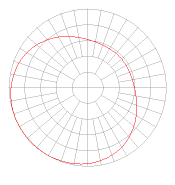 | ||||||||||||||||||
| Azimuth | Ratio | Azimuth | Ratio | Azimuth | Ratio | Azimuth | Ratio | ||||||||||||
| 0 | 0.611 | 10 | 0.587 | 20 | 0.574 | 30 | 0.567 | ||||||||||||
| 40 | 0.565 | 50 | 0.564 | 60 | 0.565 | 70 | 0.568 | ||||||||||||
| 80 | 0.577 | 90 | 0.595 | 100 | 0.624 | 110 | 0.665 | ||||||||||||
| 120 | 0.715 | 130 | 0.769 | 140 | 0.823 | 150 | 0.873 | ||||||||||||
| 160 | 0.913 | 170 | 0.945 | 180 | 0.967 | 190 | 0.982 | ||||||||||||
| 200 | 0.991 | 210 | 0.997 | 220 | 0.999 | 230 | 1.000 | ||||||||||||
| 240 | 0.998 | 250 | 0.993 | 260 | 0.984 | 270 | 0.970 | ||||||||||||
| 280 | 0.950 | 290 | 0.922 | 300 | 0.886 | 310 | 0.842 | ||||||||||||
| 320 | 0.791 | 330 | 0.739 | 340 | 0.688 | 350 | 0.645 | ||||||||||||
Structure Registration Number 1030961 Structure Type: LTOWER Registered To: American Towers LLC Structure Address: 6230 Ikea Way (90332) Shawnee Mission, KS County Name: Johnson County ASR Issued: 10/03/2022 Date Built: 04/09/2013 Site Elevation: 311.8 m (1023 ft.) Structure Height: 105.2 m (345 ft.) Height Overall: 106.7 m (350 ft.) Overall Height AMSL: 418.5 m (1373 ft.) FAA Determination: 09/29/2022 FAA Study #: 2021-ACE-10067-OE FAA Circular #: 70/7460-1K Paint & Light FAA Chapters: 4, 8, 12 PRIOR STUDY 2014-ACE-1392-OE 39-00-57.8 N 94-41-24.2 W (NAD 83) 39-00-57.8 N 94-41-23.3 W (Converted to NAD 27) |
636 Minnesota Avenue Kansas City, KS 66101 Phone: 913-563-0148 Not-for-Profit | Title: President Date: 03/15/2023 Application Certifier Radio Vida Kansas, Inc. 636 Minnesota Avenue Kansas City, KS 66101 Applicant Dan J Alpert The Law Office Of Dan J. Alpert 2120 21st Rd. N Arlington, VA 22201 Legal Counsel Darryl K DeLawder Delawder Communications, Inc. P.o. Box 1095 Ashburn, VA 20146 President | |||||||||||||||||