
FCCInfo.com
A Service of Cavell, Mertz & Associates, Inc.
(855) FCC-INFO
|
|
|
|
|
||||||||||||||||
|
|
W292FT Channel: 292D 106.3 MHz Terre Haute, Indiana Service: FX - A translator or application for a translator. Facility ID: 202979 Fac. Service: FX Programming Delivery Method: Unspecified Status: Construction Permit Application Accepted: 04/26/2023 Application Granted: 05/25/2023 File Number: -0000214244 W292FT CP Expires: 05/24/2026 Application Type: Minor Modification FCC Website Links: LMS Facility Details This Application Other W292FT Applications Other W292FT Applications in CDBS Including Superseded Applications Mailing Address Correspondence for W292FT Correspondence related to application -0000214244 Service Contour - Open Street Map or USGS Map (60 dBu) Service Contour - KML / Google Earth (60 dBu) Facility Type: FM STATION Class: D, A Noncommercial educational operating with no more than 10W Site Location: 39-30-14.0 N 87-26-37.0 W (NAD 83) Site Location: 39-30-13.9 N 87-26-36.9 W (Converted to NAD 27) Effective Radiated Power: 0.25 kW Antenna Center HAAT: 0 m Antenna Center AMSL: 323.1 m (1060 ft.) Antenna Center HAG: 152.4 m (500 ft.) Site Elevation: 170.7 m. (560 ft.) Height Overall*: 210 m (689 ft.) (* As Filed In This Application, may differ from ASR Data, Below.) Directional Antenna Antenna Make/Model: Nicom BKG77-2-0.85 Antenna ID: 132584 Polarization: H
| ||||||||||||||||||
| Antenna Data for Antenna Id: 132584 W292FT FX File: -0000214244 Nicom - BKG77-2-0.85 Service: FX | 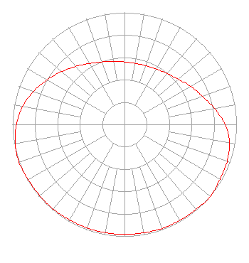 | ||||||||||||||||||
| Azimuth | Ratio | Azimuth | Ratio | Azimuth | Ratio | Azimuth | Ratio | ||||||||||||
| 0 | 0.558 | 10 | 0.553 | 20 | 0.558 | 30 | 0.571 | ||||||||||||
| 40 | 0.594 | 50 | 0.628 | 60 | 0.682 | 70 | 0.738 | ||||||||||||
| 80 | 0.815 | 90 | 0.897 | 100 | 0.953 | 110 | 0.973 | ||||||||||||
| 120 | 0.983 | 130 | 1.000 | 140 | 0.992 | 150 | 0.988 | ||||||||||||
| 160 | 0.988 | 170 | 0.983 | 180 | 0.983 | 190 | 0.983 | ||||||||||||
| 200 | 0.983 | 210 | 0.983 | 220 | 0.988 | 230 | 0.988 | ||||||||||||
| 240 | 0.992 | 250 | 1.000 | 260 | 0.991 | 270 | 0.963 | ||||||||||||
| 280 | 0.923 | 290 | 0.862 | 300 | 0.797 | 310 | 0.731 | ||||||||||||
| 320 | 0.676 | 330 | 0.628 | 340 | 0.594 | 350 | 0.571 | ||||||||||||
Structure Registration Number 1029491 Structure Type: TOWER Structure Address: 1647 W Mulberry Ave Terre Haute, IN County Name: Vigo County ASR Issued: 09/28/2004 Date Built: 05/01/1997 Site Elevation: 170.7 m (560 ft.) Structure Height: 210 m (689 ft.) Height Overall: 210 m (689 ft.) Overall Height AMSL: 380.7 m (1249 ft.) FAA Determination: 06/03/1997 FAA Study #: 97-AGL-2450-OE FAA Circular #: 70/7460-1J Paint & Light FAA Chapters: 3, 4, 5, 13 39-30-14.0 N 87-26-37.0 W (NAD 83) 39-30-13.9 N 87-26-36.9 W (Converted to NAD 27) |
8651 E 700 S Upland, IN 46989 Phone: 618-423-2082 Not-for-Profit | Title: President Date: 04/26/2023 Application Certifier American Hope Communications, Inc. American Hope Communications, Inc. 8651 E 700 S Upland, IN 46989 Applicant Thomas Henry DUKE Duke Southmayd & Miller Po Box 2360 Flagler Beach, FL 32136 ATTORNEY CHARLES M ANDERSON Anderson Associates 5900 Lake Cyrus Drive Hoover, AL 35244 Broadcast Consultant | |||||||||||||||||