
FCCInfo.com
A Service of Cavell, Mertz & Associates, Inc.
(855) FCC-INFO
|
|
K229DB from 04/08/2014 |
|
|
||||||||||||||||
|
|
K229DB Channel: 229D 93.7 MHz Phoenix, Arizona Service: FX - A translator or application for a translator. Facility ID: 151323 Fac. Service: FX Programming Delivery Method: Unspecified Status: License Application Accepted: 06/02/2023 Application Granted: 06/13/2023 File Number: -0000216175 License Expires: 10/01/2029 Application Type: License To Cover FCC Website Links: LMS Facility Details This Application Other K229DB Applications Other K229DB Applications in CDBS Including Superseded Applications Mailing Address Correspondence for K229DB Correspondence related to application -0000216175 Service Contour - Open Street Map or USGS Map (60 dBu) Service Contour - KML / Google Earth (60 dBu) Facility Type: FM STATION Class: D, A Noncommercial educational operating with no more than 10W Site Location: 33-20-03.7 N 112-03-41.2 W (NAD 83) Site Location: 33-20-03.5 N 112-03-38.7 W (Converted to NAD 27) Effective Radiated Power: 0.25 kW Transmitter Output Power: 0.185 kW Antenna Center HAAT: 0 m Antenna Center AMSL: 826.7 m (2712 ft.) Antenna Center HAG: 30.5 m (100 ft.) Site Elevation: 796.2 m. (2612 ft.) Height Overall*: 100.6 m (330 ft.) (* As Filed In This Application, may differ from ASR Data, Below.) Directional Antenna Antenna Make/Model: Scala Two CA5-FM/CP/RM/50N Antenna ID: 124869 Polarization: H
| ||||||||||||||||||
| Antenna Data for Antenna Id: 124869 K229DB FX File: -0000216175 Scala - Two CA5-FM/CP/RM/50N Service: FX | 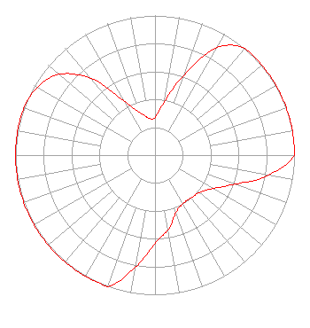 | ||||||||||||||||||
| Azimuth | Ratio | Azimuth | Ratio | Azimuth | Ratio | Azimuth | Ratio | ||||||||||||
| 0 | 0.270 | 10 | 0.388 | 20 | 0.614 | 30 | 0.888 | ||||||||||||
| 40 | 1.000 | 50 | 1.000 | 60 | 1.000 | 70 | 1.000 | ||||||||||||
| 80 | 1.000 | 90 | 1.000 | 100 | 0.827 | 110 | 0.609 | ||||||||||||
| 120 | 0.479 | 130 | 0.416 | 140 | 0.400 | 150 | 0.400 | ||||||||||||
| 160 | 0.438 | 170 | 0.543 | 180 | 0.632 | 190 | 0.818 | ||||||||||||
| 200 | 1.000 | 210 | 1.000 | 220 | 1.000 | 230 | 1.000 | ||||||||||||
| 240 | 1.000 | 250 | 1.000 | 260 | 1.000 | 270 | 1.000 | ||||||||||||
| 280 | 1.000 | 290 | 1.000 | 300 | 0.973 | 310 | 0.900 | ||||||||||||
| 320 | 0.719 | 330 | 0.450 | 340 | 0.330 | 350 | 0.270 | ||||||||||||
Structure Registration Number 1308803 Structure Type: LTOWER Registered To: Vertical Bridge Development, LLC Structure Address: South Mountain/sec 16, T1s-r3e / Us-az-5065 Phoenix, AZ County Name: Maricopa County ASR Issued: 12/27/2018 Date Built: 11/12/2021 Site Elevation: 796.2 m (2612 ft.) Structure Height: 91.4 m (300 ft.) Height Overall: 100.6 m (330 ft.) Overall Height AMSL: 896.8 m (2942 ft.) FAA Determination: 10/16/2018 FAA Study #: 2018-AWP-13927-OE Paint & Light FAA Chapters: NONE 33-20-03.7 N 112-03-41.2 W (NAD 83) 33-20-03.5 N 112-03-38.7 W (Converted to NAD 27) |
7136 S. Yale Avenue Suite 501 Tulsa, OK 74136 Phone: 918-664-4581 Limited Liability Company | Title: Vp, Technical Regulatory Affairs Date: 06/02/2023 Application Certifier IHM LICENSES, LLC Ihm Licenses, Llc 7136 S. Yale Avenue Suite 501 Tulsa, OK 74136 Applicant Troy G Langham Ihm Licenses, Llc 7136 S. Yale Avenue Suite 501 Tulsa, OK 74136 VP, Technical Regulatory Affairs | |||||||||||||||||