
FCCInfo.com
A Service of Cavell, Mertz & Associates, Inc.
(855) FCC-INFO
|
|
KYFS from 06/30/1982 |
|  |
|
|||||||||||||||
|
|
KYFS Channel: 215C1 90.9 MHz San Antonio, Texas Service: FM - A full-service FM station or application. Facility ID: 5115 Fac. Service: FM Status: License Application Accepted: 07/17/2023 Application Granted: 08/16/2023 File Number: -0000218010 License Expires: 08/01/2029 Application Type: License To Cover FCC Website Links: LMS Facility Details This Application Other KYFS Applications Other KYFS Applications in CDBS Including Superseded Applications Mailing Address Correspondence for KYFS Correspondence related to application -0000218010 Service Contour - Open Street Map or USGS Map (60 dBu) Service Contour - KML / Google Earth (60 dBu) Public Inspection Files Facility Type: NON-COMMERCIAL EDUC. FM Class: C1, A Zone II station; with 50kW-100kW ERP and a class contour distance 52km-72km Site Location: 29-40-22.1 N 98-14-49.8 W (NAD 83) Site Location: 29-40-21.3 N 98-14-48.8 W (Converted to NAD 27) Effective Radiated Power: 100 kW Transmitter Output Power: 23.5 kW Antenna Center HAAT: 136 m (446 ft.) Antenna Center AMSL: 400 m (1312 ft.) Antenna Center HAG: 134 m (440 ft.) Site Elevation: 266.1 m. (873 ft.) Height Overall*: 143.9 m (472 ft.) (* As Filed In This Application, may differ from ASR Data, Below.) Directional Antenna Antenna Make/Model: Jampro Antennas, Inc. JHPC-6DA, six sections Antenna ID: 118742 Polarization: H
| ||||||||||||||||||
| Antenna Data for Antenna Id: 118742 KYFS FM File: -0000218010 Jampro Antennas, Inc. - JHPC-6DA, six sections Service: FM | 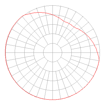 | ||||||||||||||||||
| Azimuth | Ratio | Azimuth | Ratio | Azimuth | Ratio | Azimuth | Ratio | ||||||||||||
| 0 | 0.800 | 10 | 0.750 | 20 | 0.707 | 30 | 0.707 | ||||||||||||
| 40 | 0.707 | 50 | 0.750 | 60 | 0.800 | 70 | 0.850 | ||||||||||||
| 80 | 0.900 | 90 | 0.950 | 100 | 1.000 | 110 | 1.000 | ||||||||||||
| 120 | 1.000 | 130 | 1.000 | 140 | 1.000 | 150 | 1.000 | ||||||||||||
| 160 | 1.000 | 170 | 1.000 | 180 | 1.000 | 190 | 1.000 | ||||||||||||
| 200 | 1.000 | 210 | 1.000 | 220 | 1.000 | 230 | 1.000 | ||||||||||||
| 240 | 1.000 | 250 | 1.000 | 260 | 1.000 | 270 | 1.000 | ||||||||||||
| 280 | 1.000 | 290 | 1.000 | 300 | 1.000 | 310 | 1.000 | ||||||||||||
| 320 | 1.000 | 330 | 0.950 | 340 | 0.900 | 350 | 0.850 | ||||||||||||
Structure Registration Number 1002316 Structure Type: GTOWER Registered To: Bible Broadcasting Network, Inc. Structure Address: 0.35 Km Northwest Of The Intersection Of Schuetz Dr And Coyote Run (rd) New Braunfels, TX County Name: Comal County ASR Issued: 01/27/2023 Date Built: 01/01/1993 Site Elevation: 266.1 m (873 ft.) Structure Height: 143 m (469 ft.) Height Overall: 143.9 m (472 ft.) Overall Height AMSL: 410 m (1345 ft.) FAA Determination: 01/25/2023 FAA Study #: 2022-ASW-19362-OE FAA Circular #: 70/7460-1H Paint & Light FAA Chapters: 4, 6, 13 PRIOR STUDY 2014-ASW-1952-OE 29-40-22.1 N 98-14-49.8 W (NAD 83) 29-40-21.3 N 98-14-48.8 W (Converted to NAD 27) |
11530 Carmel Commons Blvd Charlotte, NC 28226 Phone: 704-523-5555 Not-for-Profit | Title: Secretary-treasurer Date: 07/17/2023 Application Certifier BIBLE BROADCASTING NETWORK, INC. Bible Broadcasting Network, Inc. 11530 Carmel Commons Blvd Charlotte, NC 28226 Applicant Justin Asher Asher Broadcast Consulting, Llc 579 Babcock Road Bronson, MI 49028 Technical Consultant GARY S. SMITHWICK, Esq Smithwick & Belendiuk, P.c. 5028 Wisconsin Avenue, Nw Suite 301 Washington, DC 20016 Legal Counsel | |||||||||||||||||