
FCCInfo.com
A Service of Cavell, Mertz & Associates, Inc.
(855) FCC-INFO
|
|
K276CO from 02/08/2017 K276CO from 06/08/1999 K276CO from 03/09/1999 K276CO from 08/04/1987 K276CO from 06/10/1987 K276CO from 04/11/1985 |
|
|
||||||||||||||||
|
|
K276CO Channel: 276D 103.1 MHz Fayetteville, Arkansas Service: FX - A translator or application for a translator. Facility ID: 22406 Fac. Service: FX Programming Delivery Method: Unspecified Status: License Application Accepted: 08/24/2023 Application Granted: 08/25/2023 File Number: -0000219813 License Expires: 06/01/2028 Application Type: License To Cover FCC Website Links: LMS Facility Details This Application Other K276CO Applications Other K276CO Applications in CDBS Including Superseded Applications Mailing Address Correspondence for K276CO Correspondence related to application -0000219813 Service Contour - Open Street Map or USGS Map (60 dBu) Service Contour - KML / Google Earth (60 dBu) Facility Type: FM STATION Class: D, A Noncommercial educational operating with no more than 10W Site Location: 36-08-50.0 N 94-11-14.0 W (NAD 83) Site Location: 36-08-49.7 N 94-11-13.3 W (Converted to NAD 27) Effective Radiated Power: 0.14 kW Transmitter Output Power: 0.097 kW Antenna Center HAAT: 0 m Antenna Center AMSL: 560.9 m (1840 ft.) Antenna Center HAG: 147 m (482 ft.) Site Elevation: 413.9 m. (1358 ft.) Height Overall*: 151.5 m (497 ft.) (* As Filed In This Application, may differ from ASR Data, Below.) Directional Antenna Antenna Make/Model: NICOM BKG77 Antenna ID: 127185 Polarization: H
| ||||||||||||||||||
| Antenna Data for Antenna Id: 127185 K276CO FX File: -0000219813 NICOM - BKG77 Service: FX | 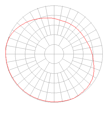 | ||||||||||||||||||
| Azimuth | Ratio | Azimuth | Ratio | Azimuth | Ratio | Azimuth | Ratio | ||||||||||||
| 0 | 0.732 | 10 | 0.707 | 20 | 0.702 | 30 | 0.702 | ||||||||||||
| 40 | 0.702 | 50 | 0.702 | 60 | 0.706 | 70 | 0.720 | ||||||||||||
| 80 | 0.748 | 90 | 0.784 | 100 | 0.822 | 110 | 0.875 | ||||||||||||
| 120 | 0.927 | 130 | 0.961 | 140 | 0.977 | 150 | 0.990 | ||||||||||||
| 156 | 1.000 | 160 | 0.997 | 170 | 0.990 | 180 | 0.988 | ||||||||||||
| 190 | 0.986 | 200 | 0.983 | 210 | 0.983 | 220 | 0.983 | ||||||||||||
| 230 | 0.983 | 240 | 0.985 | 250 | 0.988 | 260 | 0.990 | ||||||||||||
| 270 | 0.995 | 276 | 1.000 | 280 | 0.996 | 290 | 0.980 | ||||||||||||
| 300 | 0.947 | 310 | 0.903 | 320 | 0.857 | 330 | 0.816 | ||||||||||||
| 340 | 0.780 | 350 | 0.750 | ||||||||||||||||
Structure Registration Number 1038000 Structure Type: GTOWER Registered To: K2 Towers III, LLC Structure Address: 4201 S. 56th (johnson 1) Springdale, AR County Name: Washington County ASR Issued: 03/04/2024 Date Built: 04/01/1988 Site Elevation: 413.9 m (1358 ft.) Structure Height: 146.3 m (480 ft.) Height Overall: 151.5 m (497 ft.) Overall Height AMSL: 565.4 m (1855 ft.) FAA Determination: 09/05/1997 FAA Study #: 97-ASW-2394-OE FAA Circular #: Paint & Light FAA Chapters: 1, 3, 4, 13, 21 RED LIGHTS/PAINT 36-08-50.0 N 94-11-14.0 W (NAD 83) 36-08-49.7 N 94-11-13.3 W (Converted to NAD 27) |
117 Belle Avenue Fort Smith, AR 72901 Phone: 479-785-2526 Trust | Title: Technical Consultant Date: 08/24/2023 Application Certifier THE BAKER FAMILY TRUST The Baker Family Trust 117 Belle Avenue Fort Smith, AR 72901 Applicant Donald Lynch Horizon Broadcast Solutions, Llc 111 Sam Houston Drive Kerrville, TX 78028 KATHLEEN VICTORY Fletcher, Heald & Hildreth, P.l.c. 1300 North 17th Street 11th Floor Arlington, VA 22209 MEMBER | |||||||||||||||||