
FCCInfo.com
A Service of Cavell, Mertz & Associates, Inc.
(855) FCC-INFO
|
|
WEHN from 07/21/2003 WEHN from 09/01/1992 WEHN from 05/01/1991 WEHN from 03/23/1990 |
|
|
||||||||||||||||
|
|
WEHN Channel: 245A 96.9 MHz East Hampton, New York Service: FM - A full-service FM station or application. Facility ID: 18218 Fac. Service: FM Status: Construction Permit 73.215 Station Application Accepted: 09/01/2023 Application Granted: 10/13/2023 File Number: -0000220375 WEHN CP Expires: 10/13/2026 Application Type: Minor Modification FCC Website Links: LMS Facility Details This Application Other WEHN Applications Other WEHN Applications in CDBS Including Superseded Applications Mailing Address Correspondence for WEHN Correspondence related to application -0000220375 Service Contour - Open Street Map or USGS Map (60 dBu) Service Contour - KML / Google Earth (60 dBu) Public Inspection Files Facility Type: FM STATION Class: A, A Zone I; I-A; or II station; with 0.1kW-6kW ERP and a class contour distance <=28km Site Location: 41-01-53.4 N 71-58-32.7 W (NAD 83) Site Location: 41-01-53.0 N 71-58-34.4 W (Converted to NAD 27) Effective Radiated Power: 6 kW Antenna Center HAAT: 96 m (315 ft.) Antenna Center AMSL: 98 m (322 ft.) Antenna Center HAG: 43 m (141 ft.) Site Elevation: 54.3 m. (178 ft.) Height Overall*: 59.1 m (194 ft.) (* As Filed In This Application, may differ from ASR Data, Below.) Directional Antenna Antenna Make/Model: None Antenna ID: 1006063 Polarization: | ||||||||||||||||||
| Antenna Data for Antenna Id: 1006063 WEHN FM File: -0000220375 None - Service: FM | 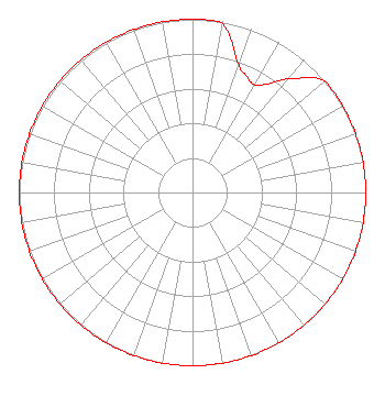 | ||||||||||||||||||
| Azimuth | Ratio | Azimuth | Ratio | Azimuth | Ratio | Azimuth | Ratio | ||||||||||||
| 0 | 1.000 | 10 | 0.988 | 20 | 0.785 | 25 | 0.741 | ||||||||||||
| 30 | 0.716 | 35 | 0.767 | 40 | 0.861 | 50 | 1.000 | ||||||||||||
| 60 | 1.000 | 70 | 1.000 | 80 | 1.000 | 90 | 1.000 | ||||||||||||
| 100 | 1.000 | 110 | 1.000 | 120 | 1.000 | 130 | 1.000 | ||||||||||||
| 140 | 1.000 | 150 | 1.000 | 160 | 1.000 | 170 | 1.000 | ||||||||||||
| 180 | 1.000 | 190 | 1.000 | 200 | 1.000 | 210 | 1.000 | ||||||||||||
| 220 | 1.000 | 230 | 1.000 | 240 | 1.000 | 250 | 1.000 | ||||||||||||
| 260 | 1.000 | 270 | 1.000 | 280 | 1.000 | 290 | 1.000 | ||||||||||||
| 300 | 1.000 | 310 | 1.000 | 320 | 1.000 | 330 | 1.000 | ||||||||||||
| 340 | 1.000 | 350 | 1.000 | ||||||||||||||||
Structure Registration Number 1316738 Structure Type: LTOWER Registered To: East Hampton, Town Of Structure Address: 365 Montauk Hwy Montauk, NY County Name: Suffolk County ASR Issued: 10/26/2020 Date Built: 05/20/2021 Site Elevation: 54.3 m (178 ft.) Structure Height: 54.9 m (180 ft.) Height Overall: 59.1 m (194 ft.) Overall Height AMSL: 113.4 m (372 ft.) FAA Determination: 05/29/2020 FAA Study #: 2020-AEA-5424-OE Paint & Light FAA Chapters: NONE PRIOR STUDY 2020-AEA-2887-OE 41-01-53.4 N 71-58-32.7 W (NAD 83) 41-01-53.0 N 71-58-34.4 W (Converted to NAD 27) |
P.o. Box 157 Water Mill, NY 11976 Phone: 631-267-7800 Limited Liability Company | Title: Member Date: 09/01/2023 Application Certifier LRS RADIO, LLC Lrs Radio, Llc P.o. Box 157 Water Mill, NY 11976 Applicant Lauren Stone Lrs Radio, Llc 760 Montauk Highway Suite 1c Water Mill, NY 11976 Joseph M. Davis, P.E. Chesapeake Rf Consultants, Llc 207 Old Dominion Road Yorktown, VA 23692 Consulting Engineer Dennis P. Corbett Telecommunications Law Professionals Pllc 1025 Connecticut Ave, Nw Suite 1011 Washington, DC 20036 Stefan Rybak Lrs Radio, Llc 760 Montauk Highway Suite 1c Water Mill, NY 11976 Harry Wareing Lrs Radio, Llc 760 Montauk Highway Suite 1c Water Mill, NY 11976 | |||||||||||||||||