
FCCInfo.com
A Service of Cavell, Mertz & Associates, Inc.
(855) FCC-INFO
|
|
WLKP from 07/06/1990 WLKP from 04/19/1990 |
|
|
||||||||||||||||
|
|
WLKP Channel: 220A 91.9 MHz Belpre, Ohio Service: FM - A full-service FM station or application. Facility ID: 38912 Fac. Service: FM Status: Construction Permit 73.215 Station Application Accepted: 09/15/2023 Application Granted: 10/12/2023 File Number: -0000221049 WLKP CP Expires: 10/12/2026 Application Type: Minor Modification FCC Website Links: LMS Facility Details This Application Other WLKP Applications Other WLKP Applications in CDBS Including Superseded Applications Mailing Address Correspondence for WLKP Correspondence related to application -0000221049 Service Contour - Open Street Map or USGS Map (60 dBu) Service Contour - KML / Google Earth (60 dBu) Public Inspection Files Facility Type: NON-COMMERCIAL EDUC. FM Class: A, A Zone I; I-A; or II station; with 0.1kW-6kW ERP and a class contour distance <=28km Site Location: 39-20-35.0 N 81-29-52.0 W (NAD 83) Site Location: 39-20-34.7 N 81-29-52.6 W (Converted to NAD 27) Effective Radiated Power: 2.9 kW Antenna Center HAAT: 108 m (354 ft.) Antenna Center AMSL: 338 m (1109 ft.) Antenna Center HAG: 40 m (131 ft.) Site Elevation: 298.7 m. (980 ft.) Height Overall*: 57.9 m (190 ft.) (* As Filed In This Application, may differ from ASR Data, Below.) Directional Antenna Antenna Make/Model: None Antenna ID: 71581 Polarization:
| ||||||||||||||||||
| Antenna Data for Antenna Id: 71581 WLKP FM File: -0000221049 None - Service: FM | 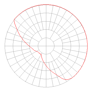 | ||||||||||||||||||
| Azimuth | Ratio | Azimuth | Ratio | Azimuth | Ratio | Azimuth | Ratio | ||||||||||||
| 0 | 1.000 | 10 | 1.000 | 20 | 1.000 | 30 | 1.000 | ||||||||||||
| 40 | 1.000 | 50 | 1.000 | 60 | 1.000 | 70 | 1.000 | ||||||||||||
| 80 | 1.000 | 90 | 1.000 | 100 | 1.000 | 110 | 1.000 | ||||||||||||
| 120 | 1.000 | 130 | 1.000 | 140 | 1.000 | 150 | 0.941 | ||||||||||||
| 160 | 0.747 | 170 | 0.602 | 180 | 0.478 | 190 | 0.380 | ||||||||||||
| 200 | 0.302 | 210 | 0.240 | 220 | 0.240 | 230 | 0.240 | ||||||||||||
| 240 | 0.265 | 250 | 0.306 | 260 | 0.343 | 270 | 0.408 | ||||||||||||
| 280 | 0.514 | 290 | 0.647 | 300 | 0.815 | 310 | 1.000 | ||||||||||||
| 320 | 1.000 | 330 | 1.000 | 340 | 1.000 | 350 | 1.000 | ||||||||||||
Structure Registration Number 1033639 Structure Type: Registered To: LLoyd Hoff Holding Corp. Structure Address: Hill Top Located On Wood Cty Rd 8 Nr Vienna, WV County Name: Wood County ASR Issued: 03/31/2022 Date Built: 09/30/1986 Site Elevation: 298.7 m (980 ft.) Structure Height: 57.9 m (190 ft.) Height Overall: 57.9 m (190 ft.) Overall Height AMSL: 356.6 m (1170 ft.) FAA Determination: 08/11/1986 FAA Study #: 86-AEA-0816-OE Paint & Light FAA Chapters: NONE 39-20-35.0 N 81-29-52.0 W (NAD 83) 39-20-34.7 N 81-29-52.6 W (Converted to NAD 27) |
5700 West Oaks Blvd. Rocklin, CA 95765 Phone: 916-251-1600 Not-for-Profit | Title: Chief Financial Officer Date: 09/15/2023 Application Certifier EDUCATIONAL MEDIA FOUNDATION Educational Media Foundation 5700 West Oaks Blvd. Rocklin, CA 95765 Applicant MARY O'CONNOR Wilkinson Barker Knauer, Llp 1800 M. Street, N.w., Suite 800n Washington, DC 20036 JAMES L TRAVIS Educational Media Foundation 5700 West Oaks Blvd Rocklin, CA 95765 FCC COMPLIANCE ENGINEER | |||||||||||||||||