
FCCInfo.com
A Service of Cavell, Mertz & Associates, Inc.
(855) FCC-INFO
|
|
WPTI from 03/12/2003 WPTI from 01/23/2001 WPTI from 07/27/1992 WPTI from 11/01/1991 |
|
|
|||||||||||||||||||||||||
|
|
WPTI Channel: 233C1 94.5 MHz Eden, North Carolina Service: FM - A full-service FM station or application. Facility ID: 55754 Fac. Service: FM Analog & Digital Status: Construction Permit 73.215 Station Application Accepted: 10/11/2023 Application Granted: 11/15/2023 File Number: -0000222535 WPTI CP Expires: 11/15/2026 Application Type: Minor Modification FCC Website Links: LMS Facility Details This Application Other WPTI Applications Other WPTI Applications in CDBS Including Superseded Applications Mailing Address Correspondence for WPTI Correspondence related to application -0000222535 Service Contour - Open Street Map or USGS Map (60 dBu) Service Contour - KML / Google Earth (60 dBu) Public Inspection Files History Cards for WPTI Facility Type: FM STATION Class: C1, A Zone II station; with 50kW-100kW ERP and a class contour distance 52km-72km Site Location: 36-16-33.0 N 79-56-25.0 W (NAD 83) Site Location: 36-16-32.5 N 79-56-25.9 W (Converted to NAD 27) Effective Radiated Power: 100 kW Antenna Center HAAT: 268 m (879 ft.) Antenna Center AMSL: 515 m (1690 ft.) Antenna Center HAG: 238 m (781 ft.) Site Elevation: 277.4 m. (910 ft.) Height Overall*: 335.6 m (1101 ft.) (* As Filed In This Application, may differ from ASR Data, Below.) Directional Antenna Antenna Make/Model: None Antenna ID: 1006063 Polarization: | |||||||||||||||||||||||||||
| Antenna Data for Antenna Id: 1006063 WPTI FM File: -0000222535 None - Service: FM | 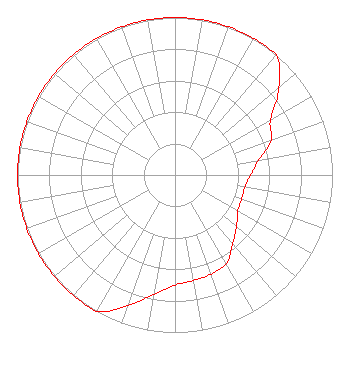 | |||||||||||||||||||||||||||
| Azimuth | Ratio | Azimuth | Ratio | Azimuth | Ratio | Azimuth | Ratio | |||||||||||||||||||||
| 0 | 1.000 | 10 | 1.000 | 20 | 1.000 | 30 | 1.000 | |||||||||||||||||||||
| 40 | 1.000 | 50 | 0.860 | 60 | 0.700 | 70 | 0.650 | |||||||||||||||||||||
| 80 | 0.540 | 90 | 0.480 | 100 | 0.450 | 110 | 0.450 | |||||||||||||||||||||
| 120 | 0.460 | 130 | 0.510 | 140 | 0.570 | 150 | 0.650 | |||||||||||||||||||||
| 160 | 0.670 | 170 | 0.680 | 180 | 0.700 | 190 | 0.770 | |||||||||||||||||||||
| 200 | 0.880 | 210 | 1.000 | 220 | 1.000 | 230 | 1.000 | |||||||||||||||||||||
| 240 | 1.000 | 250 | 1.000 | 260 | 1.000 | 270 | 1.000 | |||||||||||||||||||||
| 280 | 1.000 | 290 | 1.000 | 300 | 1.000 | 310 | 1.000 | |||||||||||||||||||||
| 320 | 1.000 | 330 | 1.000 | 340 | 1.000 | 350 | 1.000 | |||||||||||||||||||||
Structure Registration Number 1005090 Structure Type: TOWER Registered To: GTC Uno, LLC Structure Address: 1.2 Km S Jct Us-220 And Rt 68 Summerfield, NC County Name: Rockingham County ASR Issued: 12/27/2023 Date Built: 04/16/1991 Site Elevation: 277.4 m (910 ft.) Structure Height: 304.9 m (1000 ft.) Height Overall: 335.6 m (1101 ft.) Overall Height AMSL: 613 m (2011 ft.) Paint & Light FAA Chapters: A1, B, E, H 36-16-33.0 N 79-56-25.0 W (NAD 83) 36-16-32.5 N 79-56-25.9 W (Converted to NAD 27) |
7136 S. Yale Avenue Suite Tulsa, OK 74136 Phone: 918-664-4581 Corporation | Title: Vp, Technical Regulatory Affairs Date: 10/11/2023 Application Certifier IHM LICENSES, LLC Ihm Licenses, Llc 7136 S. Yale Avenue Suite Tulsa, OK 74136 Applicant Troy G Langham Ihm Licenses, Llc 7136 S. Yale Avenue Suite 501 Tulsa, OK 74136 VP, Technical Regulatory Affairs | ||||||||||||||||||||||||||
|
| |||||||||||||||||||||||||||