
FCCInfo.com
A Service of Cavell, Mertz & Associates, Inc.
(855) FCC-INFO
|
|
|
|  |
|
||||||||||||||||||
|
|
KBSX Channel: 218C 91.5 MHz Boise, Idaho Service: FM - A full-service FM station or application. Facility ID: 28243 Fac. Service: FM Analog & Digital Status: Construction Permit Application Accepted: 12/15/2023 Application Granted: 01/11/2024 File Number: -0000233188 KBSX CP Expires: 12/06/2026 Application Type: Minor Modification FCC Website Links: LMS Facility Details This Application Other KBSX Applications Other KBSX Applications in CDBS Including Superseded Applications Mailing Address Correspondence for KBSX Correspondence related to application -0000233188 Service Contour - Open Street Map or USGS Map (60 dBu) Service Contour - KML / Google Earth (60 dBu) Public Inspection Files Facility Type: NON-COMMERCIAL EDUC. FM Class: C, A Zone II station; with exactly 100kW ERP and a class contour distance 72km-92km Site Location: 43-45-20.8 N 116-05-57.0 W (NAD 83) Site Location: 43-45-21.2 N 116-05-53.6 W (Converted to NAD 27) Effective Radiated Power: 27 kW Antenna Center HAAT: 853 m (2799 ft.) Antenna Center AMSL: 2241 m (7352 ft.) Antenna Center HAG: 90 m (295 ft.) Site Elevation: 2151 m. (7057 ft.) Height Overall*: 102.4 m (336 ft.) (* As Filed In This Application, may differ from ASR Data, Below.) Directional Antenna Antenna Make/Model: None Antenna ID: 1006063 Polarization:
| |||||||||||||||||||||
| Antenna Data for Antenna Id: 1006063 KBSX FM File: -0000233188 None - Service: FM | 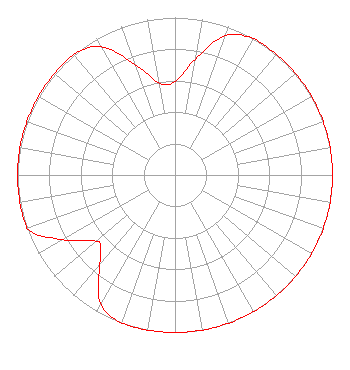 | |||||||||||||||||||||
| Azimuth | Ratio | Azimuth | Ratio | Azimuth | Ratio | Azimuth | Ratio | |||||||||||||||
| 0 | 0.594 | 10 | 0.747 | 20 | 0.941 | 30 | 1.000 | |||||||||||||||
| 40 | 1.000 | 50 | 1.000 | 60 | 1.000 | 70 | 1.000 | |||||||||||||||
| 80 | 1.000 | 90 | 1.000 | 100 | 1.000 | 110 | 1.000 | |||||||||||||||
| 120 | 1.000 | 130 | 1.000 | 140 | 1.000 | 150 | 1.000 | |||||||||||||||
| 160 | 1.000 | 170 | 1.000 | 180 | 1.000 | 190 | 1.000 | |||||||||||||||
| 200 | 1.000 | 210 | 0.944 | 220 | 0.750 | 225 | 0.668 | |||||||||||||||
| 230 | 0.653 | 240 | 0.822 | 250 | 1.000 | 260 | 1.000 | |||||||||||||||
| 270 | 1.000 | 280 | 1.000 | 290 | 1.000 | 300 | 1.000 | |||||||||||||||
| 310 | 1.000 | 320 | 1.000 | 330 | 0.941 | 340 | 0.747 | |||||||||||||||
| 350 | 0.594 | |||||||||||||||||||||
Structure Registration Number 1209884 Structure Type: TOWER Registered To: The Deer Point Tower Venture, LLC Structure Address: 11miles North-northwest Of Boise, Id Atop Deer Point/schafer Butte Boise, ID County Name: Boise County ASR Issued: 08/22/2007 Date Built: 09/15/2001 Site Elevation: 2151 m (7057 ft.) Structure Height: 102.4 m (336 ft.) Height Overall: 102.4 m (336 ft.) Overall Height AMSL: 2253.4 m (7393 ft.) FAA Determination: 12/07/1999 FAA Study #: 99-ANM-1320-OE FAA Circular #: 70/7460-1J Paint & Light FAA Chapters: 4, 8, 13 Removed expiration date from determination. Scenario 1./jjs/case#635066 43-45-20.8 N 116-05-57.0 W (NAD 83) 43-45-21.2 N 116-05-53.6 W (Converted to NAD 27) |
1910 University Drive Boise, ID 83725 Phone: 208-426-3322 Government Entity | Title: General Manger And Executive Director Date: 12/15/2023 Application Certifier IDAHO STATE BOARD OF EDUCATION Idaho State Board Of Education 1910 University Drive Boise, ID 83725 Applicant TOM MICHAEL Boise State Radio 1910 University Dr Boise, ID 83725 GENERAL MANAGER ERIK C SWANSON, PE Hatfield & Dawson 9500 Greenwood Ave N Seattle, WA 98103 CONSULTING ENGINEER | ||||||||||||||||||||
| ||||||||||||||||||||||