
FCCInfo.com
A Service of Cavell, Mertz & Associates, Inc.
(855) FCC-INFO
|
|
KUBT from 09/14/2010 KUBT from 01/09/1989 KUBT from 10/01/1980 KUBT from 11/02/1978 |
|
|
||||||||||||||||
|
|
KUBT Channel: 230C 93.9 MHz Honolulu, Hawaii Service: FM - A full-service FM station or application. Facility ID: 34592 Fac. Service: FM Status: License Application Accepted: 01/03/2024 Application Granted: 01/19/2024 File Number: -0000234696 License Expires: 02/01/2030 Application Type: License To Cover FCC Website Links: LMS Facility Details This Application Other KUBT Applications Other KUBT Applications in CDBS Including Superseded Applications Mailing Address Correspondence for KUBT Correspondence related to application -0000234696 Service Contour - Open Street Map or USGS Map (60 dBu) Service Contour - KML / Google Earth (60 dBu) Public Inspection Files History Cards for KUBT Facility Type: FM STATION Class: C, A Zone II station; with exactly 100kW ERP and a class contour distance 72km-92km Site Location: 21-23-33.6 N 158-05-48.1 W (NAD 83) Site Location: 21-23-45.0 N 158-05-58.0 W (Converted to NAD 27) Effective Radiated Power: 100 kW Horiz. ; 81 kW Vert. Transmitter Output Power: 29 kW Antenna Center HAAT: 565 m (1854 ft.) Antenna Center AMSL: 734 m (2408 ft.) Antenna Center HAG: 39 m (128 ft.) Site Elevation: 695.1 m. (2281 ft.) Height Overall*: 60.6 m (199 ft.) (* As Filed In This Application, may differ from ASR Data, Below.) Directional Antenna Antenna Make/Model: Shively 6014-14/1-DA, 14 sections Antenna ID: 0 Polarization: H | ||||||||||||||||||
| Antenna Data for Antenna Id: 0 KUBT FM File: -0000234696 Shively - 6014-14/1-DA, 14 sections Service: FM | 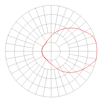 | ||||||||||||||||||
| Azimuth | Ratio | Azimuth | Ratio | Azimuth | Ratio | Azimuth | Ratio | ||||||||||||
| 0 | 0.325 | 10 | 0.390 | 20 | 0.470 | 30 | 0.560 | ||||||||||||
| 40 | 0.655 | 50 | 0.755 | 60 | 0.850 | 70 | 0.955 | ||||||||||||
| 80 | 1.000 | 90 | 1.000 | 100 | 1.000 | 110 | 0.900 | ||||||||||||
| 120 | 0.800 | 130 | 0.705 | 140 | 0.605 | 150 | 0.510 | ||||||||||||
| 160 | 0.410 | 170 | 0.330 | 180 | 0.275 | 190 | 0.245 | ||||||||||||
| 200 | 0.220 | 210 | 0.205 | 220 | 0.200 | 230 | 0.200 | ||||||||||||
| 240 | 0.200 | 250 | 0.200 | 260 | 0.200 | 270 | 0.200 | ||||||||||||
| 280 | 0.200 | 290 | 0.200 | 300 | 0.200 | 310 | 0.200 | ||||||||||||
| 320 | 0.200 | 330 | 0.215 | 340 | 0.235 | 350 | 0.270 | ||||||||||||
Structure Registration Number 1218023 Structure Type: TOWER Registered To: Salem Media of Hawaii Structure Address: Palikea Ridge, 26.9 Km Nw Of Honolulu At 292° True Makakilo, HI County Name: Honolulu County ASR Issued: 10/03/2000 Date Built: 10/03/2000 Site Elevation: 695.1 m (2281 ft.) Structure Height: 60.6 m (199 ft.) Height Overall: 60.6 m (199 ft.) Overall Height AMSL: 755.7 m (2479 ft.) FAA Determination: 09/08/2000 FAA Study #: 00-AWP-2258-OE Paint & Light FAA Chapters: NONE 21-23-33.6 N 158-05-48.1 W (NAD 83) 21-23-45.0 N 158-05-58.0 W (Converted to NAD 27) |
7136 S. Yale Avenue Suite 501 Tulsa, OK 74136 Phone: 918-664-4581 Limited Liability Company | Title: Vp, Technical Regulatory Affairs Date: 01/03/2024 Application Certifier IHM LICENSES, LLC Ihm Licenses, Llc 7136 S. Yale Avenue Suite 501 Tulsa, OK 74136 Applicant Troy Langham Iheartmedia 7136 S. Yale Avenue Suite 501 Tulsa, OK 74136 | |||||||||||||||||
| |||||||||||||||||||